METAR & TAF U52
Current METAR
Observed 15:55Z
KU52 011555Z AUTO 27005KT 10SM CLR 10/M07 A3013 RMK AO2 PWINO
- Wind
- 270° @ 5 kt
- Visibility
- 10 SM
- Temp / Dew
- 10°C / -7°C
- Altimeter
- 30.13 inHg
- Clouds
- CLR
- Density alt
- 6,410 ft
- Ceiling
- Unlimited
- Rules
- VFR
Airport info & contacts
Manager on record, flight service, ARTCC, attendance schedule and pattern altitude — published by the FAA and refreshed every 28 days.
Location
- From city
- 4 NM SW
- VFR sectional
- LAS VEGAS
- ARTCC
- ZLC · SALT LAKE CITY
- NOTAM facility
- CDC (NOTAM-D)
Airport manager
- Name
- MONTE HAWKINS
- Phone
- 435-438-2451
- Address
- 30 WEST 300 NORTH, PO BOX 271, BEAVER UT 84713
Flight service · Hours
- FSS CDC
- CEDAR CITY1-800-WX-BRIEF
- Attendance
- Unattended
Frequencies
Tap any row to copy the frequency to your clipboard.
Runways & pattern
Full pagePattern entry · RWY 25
LEFT TRAFFIC| Runway | Heading (°M) | Length | Surface | Traffic |
|---|---|---|---|---|
| 13/31 | 134° / 314° | 4,985 ft | ASPH | Standard L |
| 07/25Favored | 73° / 253° | 2,133 ft | DIRT | Standard L |
Runway end performance
| End | TORA | TODA | ASDA | LDA | VGSI | Approach lights | Obstruction |
|---|---|---|---|---|---|---|---|
| 13 | — | — | — | — | PAPI 2-box left(3°) | — | — |
| 31 | — | — | — | — | PAPI 2-box right(4°) | — | — |
Declared distances in feet. TORA = takeoff run available, TODA = takeoff distance, ASDA = accelerate-stop, LDA = landing distance.
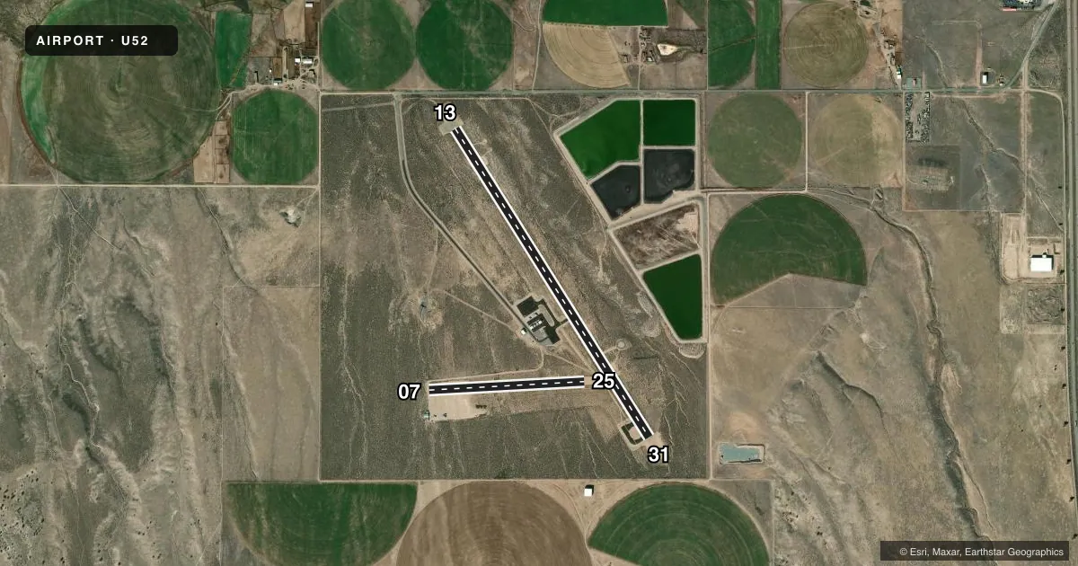
Airport sketch
Runways drawn to scale from FAA survey coordinates, rendered over satellite imagery. Not for navigation.
Approaches & charts
Services on the field
Fuel grades, oxygen, maintenance, ramp storage and lighting — as declared to the FAA by the airport operator.
Fuel & services
- Fuel
- 100LL
- Oxygen (bottled)
- Not available
- Oxygen (bulk)
- Not available
- Airframe repair
- Not available
- Power plant repair
- Not available
Ramp & ground
- Transient storage
- Tie-down
- Landing fee
- No fee published
- Customs
- Not available
- Lighting schedule
- SEE RMK
- Beacon schedule
- SS-SR
- Beacon
- White / Green (civil land)(WG)
- Wind indicator
- Yes
- Segmented circle
- Yes
Fuel & FBOs
Cheapest 100LL and Jet A on the field and nearby. Always confirm with the FBO before taxi.
Airport notes
Surface conditions, obstructions, local procedures, lighting outages and other notes published with each FAA cycle.
General notes
- BIRDS ON & INVOF ARPT.
- FOR CD CTC SALT LAKE ARTCC AT 801-320-2568.
Lighting notes
- ACTVT REIL RWY 13 & 31; PAPI RWY 13 & 31; MIRL RWY 13/31 - CTAF.
Fuel notes
- 100LL24 HR SELF SVC.
Approach & departure obstructions
- 31PAPI UNUSBL BYD 2.7 NM FM THLD DUE TO TRRN OCS PENETRATION AT 3.2 NM.
- 072 FT DELIMINATORS ACRS RWY 180 FT FM AER 25.
VFR map & nearby airports
VFR sectional. Tap any ICAO chip to open that airport.
Key facts · U52
Answer card- ICAO
- U52
- Name
- BEAVER MUNI
- Location
- BEAVER, UTAH
- Elevation
- 5,863.2 ft MSL
- Traffic pattern altitude
- 6,863.2 ft MSL (1,000 AGL)
- Control tower
- Non-towered (use CTAF)
- Total runways
- 2
- Longest runway
- 13/31 · 4,985 ft
- Published ILS approaches
- 0
- Published frequencies
- 1
- Magnetic variation
- 14°
- Current flight rules
- VFR
- Current wind
- 270° at 5 kt
- Favored runway now
- RWY 25
Beaver Muni sits in Beaver, Utah at 5,863.2 ft MSL. It has two runways. The longest is runway 13/31 at 4,985 ft. This is a non-towered field, so use CTAF 122.9 for local traffic calls. No ILS approaches are published here. Pattern altitude is not published, so use the standard 1,000 ft AGL for light piston operations unless the current Chart Supplement says otherwise.
The on-field FBO is Beaver Municipal Airport. It carries 100LL. Self-serve fuel is available 24 hours. That helps for late arrivals or early departures, but you still need to plan for mountain-field performance. The airport elevation is high enough that density altitude can matter on warm days. Runway 13/31 is the paved option. Runway 07/25 is dirt and shorter at 2,133 ft.
A few published remarks matter on the ground. Birds are reported on and near the airport. There are two-foot delimiters across runway 25 about 180 ft from the approach end. Runway 31 also has a PAPI note. The PAPI is unusable beyond 2.7 NM from the threshold because of terrain penetration farther out. If you need clearance delivery, contact Salt Lake ARTCC at 801-320-2568. Check the current Chart Supplement before you go for any updated operational notes.