METAR & TAF KFOM
Current METAR
Observed 11:35Z
KFOM 271135Z AUTO 12007KT 10SM CLR 25/09 A3010 RMK AO2
- Wind
- 120° @ 7 kt
- Visibility
- 10 SM
- Temp / Dew
- 25°C / 9°C
- Altimeter
- 30.10 inHg
- Clouds
- CLR
- Density alt
- 7,158 ft
- Ceiling
- Unlimited
- Rules
- VFR
Airport info & contacts
Manager on record, flight service, ARTCC, attendance schedule and pattern altitude — published by the FAA and refreshed every 28 days.
Location
- From city
- 2 NM W
- VFR sectional
- LAS VEGAS
- ARTCC
- ZLC · SALT LAKE CITY
- NOTAM facility
- CDC (NOTAM-D)
Airport manager
- Name
- CHRISTINE RASMUSSEN
- Phone
- (435) 253-0919
- Address
- 1120 WEST 200 SOUTH, FILLMORE UT 84631
Flight service · Hours
- FSS CDC
- CEDAR CITY1-800-WX-BRIEF
- Attendance
- ALL
Frequencies
Tap any row to copy the frequency to your clipboard.
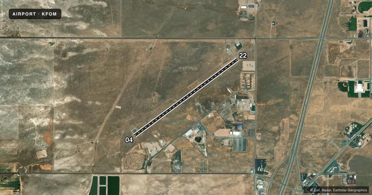
Runways & pattern
Full pagePattern entry · RWY 04
LEFT TRAFFICRunway end performance
| End | TORA | TODA | ASDA | LDA | VGSI | Approach lights | Obstruction |
|---|---|---|---|---|---|---|---|
| 04 | — | — | — | — | PAPI 2-box left(3°) | — | — |
| 22 | — | — | — | — | PAPI 2-box left(3°) | — | 27', road, 630' from thr, 312' R of cntrln, slope 15 |
Declared distances in feet. TORA = takeoff run available, TODA = takeoff distance, ASDA = accelerate-stop, LDA = landing distance.
Airport sketch
Runways drawn to scale from FAA survey coordinates, rendered over satellite imagery. Not for navigation.
Approaches & charts
Services on the field
Fuel grades, oxygen, maintenance, ramp storage and lighting — as declared to the FAA by the airport operator.
Fuel & services
- Fuel
- 100LLA
- Oxygen (bottled)
- Not available
- Oxygen (bulk)
- Not available
- Airframe repair
- Not available
- Power plant repair
- Not available
Ramp & ground
- Transient storage
- Tie-down
- Hangar
- Landing fee
- No fee published
- Customs
- Not available
- Lighting schedule
- SEE RMK
- Beacon schedule
- SS-SR
- Beacon
- White / Green (civil land)(WG)
- Wind indicator
- Lighted
- Segmented circle
- Yes
Fuel & FBOs
Cheapest 100LL and Jet A on the field and nearby. Always confirm with the FBO before taxi.
Airport notes
Surface conditions, obstructions, local procedures, lighting outages and other notes published with each FAA cycle.
General notes
- FOR CD CTC SALT LAKE ARTCC AT 801-320-2568.
- SN REMOVAL SCND PRIORITY, CALL FOR FICONS.
- AMGR LIVES ADJ.
Lighting notes
- ACTVT PAPI RWYS 04 & 22; MIRL RWY 04/22 - CTAF.
Fuel notes
- 100LL24 HR SELF SVC.
Approach & departure obstructions
- 04RWY MKGS FADED.
- 22RWY MKGS FADED.
Other notes
- EXISTED PRIOR TO 1959.
VFR map & nearby airports
VFR sectional. Tap any ICAO chip to open that airport.
Key facts · KFOM
Answer card- ICAO
- KFOM
- Name
- FILLMORE MUNI
- Location
- FILLMORE, UTAH
- Elevation
- 4,984.5 ft MSL
- Traffic pattern altitude
- 5,984.5 ft MSL (1,000 AGL)
- Control tower
- Non-towered (use CTAF)
- Total runways
- 1
- Longest runway
- 04/22 · 5,040 ft
- Published ILS approaches
- 0
- Published frequencies
- 2
- Magnetic variation
- 12°
- Current flight rules
- VFR
- Current wind
- 120° at 7 kt
- Favored runway now
- RWY 04
Fillmore Muni sits in Fillmore, Utah. The field elevation is 4,984.5 ft MSL. It has one runway, 04/22, at 5,040 ft. There is no control tower. CTAF and UNICOM are both 122.8. No ILS approaches are published here.
Pattern altitude is not published. Use the standard 1,000 ft AGL pattern unless the current Chart Supplement or local guidance says otherwise. The on-field FBO is Fillmore Municipal Airport. It carries AVGAS 100LL and JET A. 100LL is available 24 hours by self-service. PAPI is available on runways 04 and 22. Medium intensity runway lights are on 04/22 and are controlled by CTAF.
A few remarks matter for first-time arrivals. Runway markings on both ends are faded. Snow removal is second priority, so call for field conditions before you go. Clearance delivery is handled through Salt Lake ARTCC at 801-320-2568. The airport sits at high elevation, so expect performance to be different from a lowland strip. Check density altitude before departure, especially on warm days. If you need current operational details, use the current FAA Chart Supplement or call the airport operator or the FBO directly by phone.