METAR & TAF KMLF
Current METAR
Observed 12:52Z
KMLF 271252Z AUTO 22011KT 10SM BKN110 23/11 A3012 RMK AO2 SLP122 T02280111 TSNO $
- Wind
- 220° @ 11 kt
- Visibility
- 10 SM
- Temp / Dew
- 23°C / 11°C
- Altimeter
- 30.12 inHg
- Clouds
- BKN
- Density alt
- 6,964 ft
- Ceiling
- 11,000 ft AGL
- Rules
- VFR
Airport info & contacts
Manager on record, flight service, ARTCC, attendance schedule and pattern altitude — published by the FAA and refreshed every 28 days.
Location
- From city
- 2 NM N
- VFR sectional
- LAS VEGAS
- ARTCC
- ZLC · SALT LAKE CITY
- NOTAM facility
- MLF (NOTAM-D)
Airport manager
- Name
- MAKAYLA BEALER
- Phone
- 435-463-9565
- Address
- PO BOX 69, 26 SOUTH 100 WEST, MILFORD UT 84751
Flight service · Hours
- FSS CDC
- CEDAR CITY1-800-WX-BRIEF
- Attendance
- Unattended
Frequencies
Tap any row to copy the frequency to your clipboard.
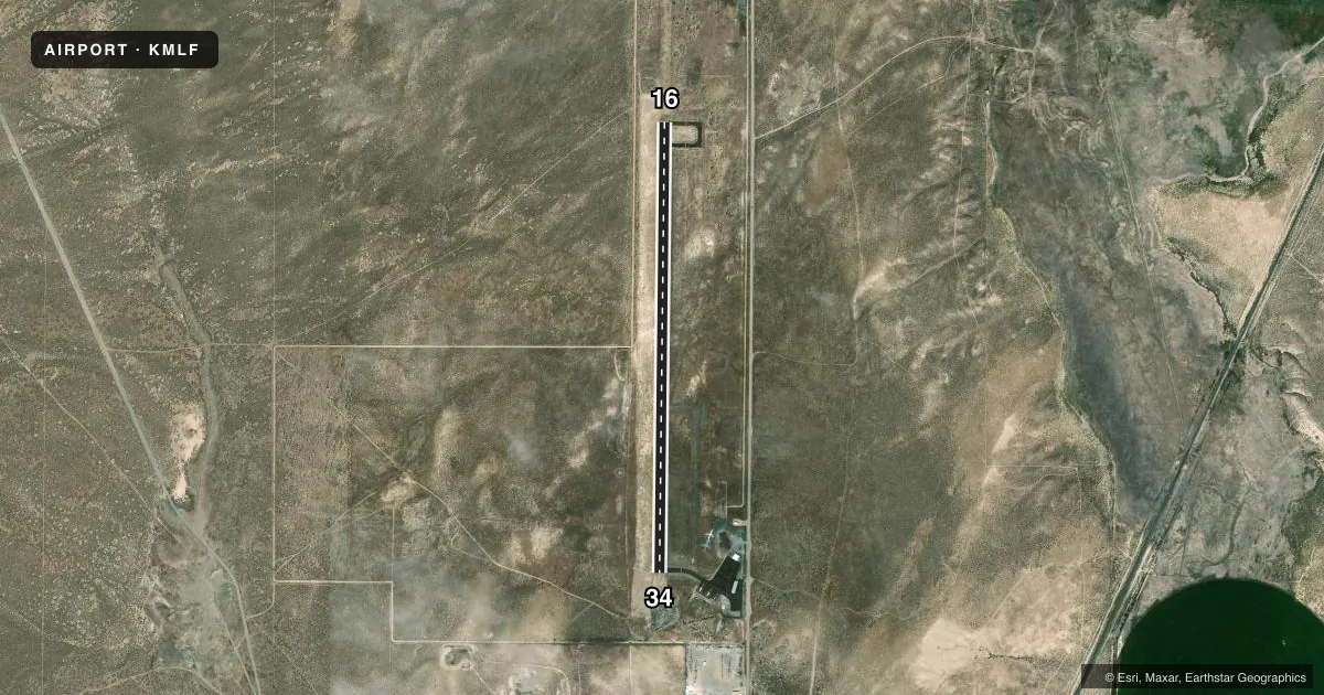
Runways & pattern
Full pagePattern entry · RWY 16
LEFT TRAFFICRunway end performance
| End | TORA | TODA | ASDA | LDA | VGSI | Approach lights | Obstruction |
|---|---|---|---|---|---|---|---|
| 16 | — | — | — | — | PAPI 2-box left(3°) | — | — |
| 34 | — | — | — | — | PAPI 2-box left(3°) | — | — |
Declared distances in feet. TORA = takeoff run available, TODA = takeoff distance, ASDA = accelerate-stop, LDA = landing distance.
Airport sketch
Runways drawn to scale from FAA survey coordinates, rendered over satellite imagery. Not for navigation.
Approaches & charts
Services on the field
Fuel grades, oxygen, maintenance, ramp storage and lighting — as declared to the FAA by the airport operator.
Fuel & services
- Fuel
- 100LLA
- Oxygen (bottled)
- Not available
- Oxygen (bulk)
- Not available
- Airframe repair
- Not available
- Power plant repair
- Not available
Ramp & ground
- Transient storage
- Tie-down
- Landing fee
- No fee published
- Customs
- Not available
- Lighting schedule
- SEE RMK
- Beacon schedule
- SS-SR
- Beacon
- White / Green (civil land)(WG)
- Wind indicator
- Lighted
- Segmented circle
- Yes
Fuel & FBOs
Cheapest 100LL and Jet A on the field and nearby. Always confirm with the FBO before taxi.
Airport notes
Surface conditions, obstructions, local procedures, lighting outages and other notes published with each FAA cycle.
General notes
- PILOTS ADZ TGL OVR CTAF.
- FOR CD IF UNA TO CTC ON FSS FREQ, CTC SALT LAKE ARTCC AT 801-320-2568.
- COLD TEMPERATURE AIRPORT. ALTITUDE CORRECTION REQUIRED AT OR BELOW -27C.
Lighting notes
- ACTVT REIL RWY 16 & 34; MIRL RWY 16/34 - CTAF. PAPI RWY 16 & 34 ON CONSLY.
Other notes
- EXISTED PRIOR TO 1959.
- MANAGERCITY/AMGR.
VFR map & nearby airports
VFR sectional. Tap any ICAO chip to open that airport.
Key facts · KMLF
Answer card- ICAO
- KMLF
- Name
- MILFORD MUNI/BEN AND JUDY BRISCOE FLD
- Location
- MILFORD, UTAH
- Elevation
- 5,042.2 ft MSL
- Traffic pattern altitude
- 6,042.2 ft MSL (1,000 AGL)
- Control tower
- Non-towered (use CTAF)
- Total runways
- 1
- Longest runway
- 16/34 · 5,004 ft
- Published ILS approaches
- 0
- Published frequencies
- 2
- Magnetic variation
- 15°
- Current flight rules
- VFR
- Current wind
- 220° at 11 kt
- Favored runway now
- RWY 16
Milford Muni / Ben and Judy Briscoe Fld sits in Milford, Utah. Field elevation is 5,042.2 ft MSL. The airport has one runway. Runway 16/34 is 5,004 ft of asphalt. There is no control tower. CTAF and UNICOM are both 122.8.
No ILS approaches are published here. The pattern altitude is not published in the facts, so use the standard 1,000 ft AGL for light piston operations unless the current Chart Supplement says otherwise. The field uses magnetic variation of 15°. Runway lighting is pilot-controlled on 122.8. REILs are available on 16 and 34. Medium intensity runway lights are also available. PAPI is listed for both runway ends.
Milford Municipal Airport is on the field. It carries 100LL and Jet A. Call the airport directly at (435) 463-9565 for current fuel and service status. The airport manager is the city airport manager. This is a cold temperature airport. Altitude correction is required at or below minus 27 degrees Celsius. Pilots also advise touch-and-go landings on CTAF, so listen before you join the pattern. For any current clearance delivery or operational detail not covered here, check the current FAA Chart Supplement or call the airport operator directly.