METAR & TAF KCDC
Current METAR
Observed 12:53Z
KCDC 271253Z AUTO 14007KT 10SM CLR 22/09 A3019 RMK AO2 SLP135 T02170094
- Wind
- 140° @ 7 kt
- Visibility
- 10 SM
- Temp / Dew
- 22°C / 9°C
- Altimeter
- 30.19 inHg
- Clouds
- CLR
- Density alt
- 7,477 ft
- Ceiling
- Unlimited
- Rules
- VFR
Airport info & contacts
Manager on record, flight service, ARTCC, attendance schedule and pattern altitude — published by the FAA and refreshed every 28 days.
Location
- From city
- 2 NM NW
- VFR sectional
- LAS VEGAS
- Pattern altitude
- 777 ft AGL · 6,399 ft MSL
- ARTCC
- ZLC · SALT LAKE CITY
- NOTAM facility
- CDC (NOTAM-D)
Airport manager
- Name
- TYLER GALETKA
- Phone
- 435-867-9408
- Address
- 2560 AVIATION WAY, CEDAR CITY UT 84721
Flight service · Hours
- FSS CDC
- CEDAR CITY1-800-WX-BRIEF
- Attendance
- DALGT
Frequencies
Tap any row to copy the frequency to your clipboard.
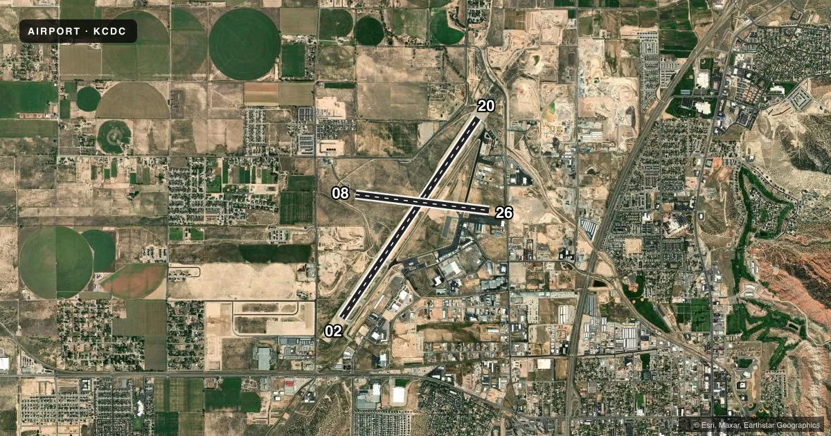
Runways & pattern
Full pagePattern entry · RWY 08
LEFT TRAFFIC| Runway | Heading (°M) | Length | Surface | Traffic |
|---|---|---|---|---|
| 02/20 | 20° / 200° | 8,653 ft | ASPH | 20 R |
| 08/26Favored | 83° / 263° | 4,822 ft | ASPH | 26 R |
Runway end performance
| End | TORA | TODA | ASDA | LDA | VGSI | Approach lights | Obstruction |
|---|---|---|---|---|---|---|---|
| 02 | 8,653' | 8,653' | 8,653' | 8,653' | PAPI 4-box left(3°) | — | — |
| 20 | 8,653' | 8,653' | 8,653' | 8,653' | PAPI 4-box left(3°) | MALSR | — |
| 08 | 4,822' | 4,822' | 4,822' | 4,822' | PAPI 4-box left(3°) | — | 40', pole, 1800' from thr, 0' R of cntrln, slope 40 |
| 26 | 4,822' | 4,822' | 4,822' | 4,822' | — | — | 18', road, 661' from thr, 0' R of cntrln, slope 26 |
Declared distances in feet. TORA = takeoff run available, TODA = takeoff distance, ASDA = accelerate-stop, LDA = landing distance.
Airport sketch
Runways drawn to scale from FAA survey coordinates, rendered over satellite imagery. Not for navigation.
Approaches & charts
ILS · 1
Services on the field
Fuel grades, oxygen, maintenance, ramp storage and lighting — as declared to the FAA by the airport operator.
Fuel & services
- Fuel
- 100LLA
- Oxygen (bottled)
- HIGH/LOW
- Airframe repair
- Major
- Power plant repair
- Major
- Other services
- AFRT,AGRI,AMB,CARGO,CHTR,INSTR,RNTL,SALES,TOW
Ramp & ground
- Transient storage
- Tie-down
- Hangar
- Landing fee
- No fee published
- Customs
- Not available
- Lighting schedule
- SEE RMK
- Beacon schedule
- SS-SR
- Beacon
- White / Green (civil land)(WG)
- Wind indicator
- Lighted
- Segmented circle
- Yes
Fuel & FBOs
Cheapest 100LL and Jet A on the field and nearby. Always confirm with the FBO before taxi.
Airport notes
Surface conditions, obstructions, local procedures, lighting outages and other notes published with each FAA cycle.
General notes
- GA ACFT NOT PERMITTED ON ACR RAMP.
- RECOMMNED PILOTS CIRCLE ARPT FOR ALT BEFORE DEPARTING EASTBOUND DUE TO FAST RISING TERRAIN AND HI DENSITY ALT. TURBC LIKELY INVOF MNTS & PASSES.
- DESIGNATED CALM WIND RWY (BLW 5 KTS) IS RWY 20, RGT TFC.
- UNMON SFC CONDS 1900-0700 DLY EXC FOR SKED ACR.
- EXTENSIVE HELICOPTER ACTIVITY.
- EXTENSIVE FLIGHT TRNG INVOF ARPT.
- AUTOROTATE - NO AUTOROTATION TRNG TO HELIPAD. RWY 02/20 CLSD TO HEL RUN-ON LNDG; RWY 08/26 CLSD TO HEL RUN-ON LNDG; TWY A, N OF RWY 8/26 CLSD TO HEL RUN-ON LNDG; TWY C CLSD TO HEL RUN-ON LNDG.
- RWY 02 LEFT TRAFFIC PATTERN EXC HELICOPTERS. RWY 20 RIGHT TRAFFIC EXC HELICOPTERS.
- FOR CD IF UNA TO CTC ON FSS FREQ, CTC SALT LAKE ARTCC AT 801-320-2568.
- RWY 2/20, A, A1-A4, C FM A TO TRML & TRML APN AVBL TO ACRS.
Lighting notes
- ACTVT MALSR RWY 20; REIL RWY 02; HIRL RWY 02/20; MIRL RWY 08/26 - CTAF. PAPI RWY 02 & 20, 08 OPER CONSLY.
Fuel notes
- 100LL100LL FUEL AVBL 24 HRS SELF-SVC CREDIT CARD SYSTEM.
Runway surface & condition
- 02/20PCR VALUE: 410/F/B/X/T
- 08/26PCR VALUE: 40/F/B/X/T
- 08/26RWY 08/26 NOT AVBL FOR PART 121/PART 380 OPS WITH SKED PAX CARRYING OPS MORE THAN 9 PAX SEATS AND NON-SKED PAX CARRYING OPS MORE THAN 30 PAX SEATS.
Approach & departure obstructions
- 0840 FT POLES ON EXTNDD RWY CNTRLN.
Other notes
- CLSD TO UNSKED ACR OPNS WITH MORE THAN 30 PSGR SEATS EXCP 24 HR PPR CALL CC FIRE DEPT 435-586-2964 AND AMGR 435-867-9408.
- 1FOR AFT HRS SVC CALL 435-586-4504
VFR map & nearby airports
VFR sectional. Tap any ICAO chip to open that airport.
Key facts · KCDC
Answer card- ICAO
- KCDC
- Name
- CEDAR CITY RGNL
- Location
- CEDAR CITY, UTAH
- Elevation
- 5,622.3 ft MSL
- Traffic pattern altitude
- 6,399.3 ft MSL (777 AGL)
- Control tower
- Non-towered (use CTAF)
- Total runways
- 2
- Longest runway
- 02/20 · 8,653 ft
- Published ILS approaches
- 1
- Published frequencies
- 2
- Magnetic variation
- 14°
- Current flight rules
- VFR
- Current wind
- 140° at 7 kt
- Favored runway now
- RWY 08
Cedar City Rgnl sits in Cedar City, Utah. Field elevation is 5,622.3 ft MSL. The airport has two asphalt runways. The longest is runway 02/20 at 8,653 ft. There is no control tower. CTAF and UNICOM are both 123.0.
The field has one ILS approach to runway 20. Pattern altitude is 777 ft AGL, which is 6,399.3 ft MSL. That matters here because the airport is already high elevation. Expect density altitude to be part of the picture, especially on warm days. Published remarks also call out fast rising terrain to the east. Pilots are advised to circle for altitude before departing eastbound. Turbulence is likely near the mountains and passes. There is also extensive helicopter activity. Flight training is common in the area.
GateOne is on the field. It carries 100LL, Jet A and Jet A Prist. 100LL is available 24 hours through self-service credit card. For after-hours service, call the FBO. Runway 08 has 40-foot poles on the extended centerline. Runway 08/26 is not available for some scheduled and non-scheduled passenger operations. Taxiway B is not available for aircraft with aircraft certification requirements. Check the current FAA Chart Supplement and call the airport operator or the FBO directly for any operational limits before you go.