METAR & TAF KSGU
Current METAR
Observed 12:56Z
KSGU 271256Z AUTO 09005KT 9SM CLR 27/12 A2999 RMK AO2 SLP112 T02670117
- Wind
- 090° @ 5 kt
- Visibility
- 9 SM
- Temp / Dew
- 27°C / 12°C
- Altimeter
- 29.99 inHg
- Clouds
- CLR
- Density alt
- 4,929 ft
- Ceiling
- Unlimited
- Rules
- VFR
Airport info & contacts
Manager on record, flight service, ARTCC, attendance schedule and pattern altitude — published by the FAA and refreshed every 28 days.
Location
- From city
- 5 NM SE
- VFR sectional
- LAS VEGAS
- ARTCC
- ZLA · LOS ANGELES
- NOTAM facility
- SGU (NOTAM-D)
Airport manager
- Name
- DUSTIN WARREN
- Phone
- 435-627-4087
- Address
- 4508 S. AIRPORT PKWY #1, ST GEORGE UT 84790
Flight service · Hours
- FSS CDC
- CEDAR CITY1-800-WX-BRIEF
- Attendance
- 0600-2400
Frequencies
Tap any row to copy the frequency to your clipboard.
Runways & pattern
Full pagePattern entry · RWY 01
LEFT TRAFFICRunway end performance
| End | TORA | TODA | ASDA | LDA | VGSI | Approach lights | Obstruction |
|---|---|---|---|---|---|---|---|
| 01 | 9,300' | 9,300' | 9,300' | 9,300' | PAPI 4-box left(3°) | — | — |
| 19 | 9,300' | 9,300' | 9,300' | 9,300' | PAPI 4-box left(3.1°) | MALSR | — |
Declared distances in feet. TORA = takeoff run available, TODA = takeoff distance, ASDA = accelerate-stop, LDA = landing distance.
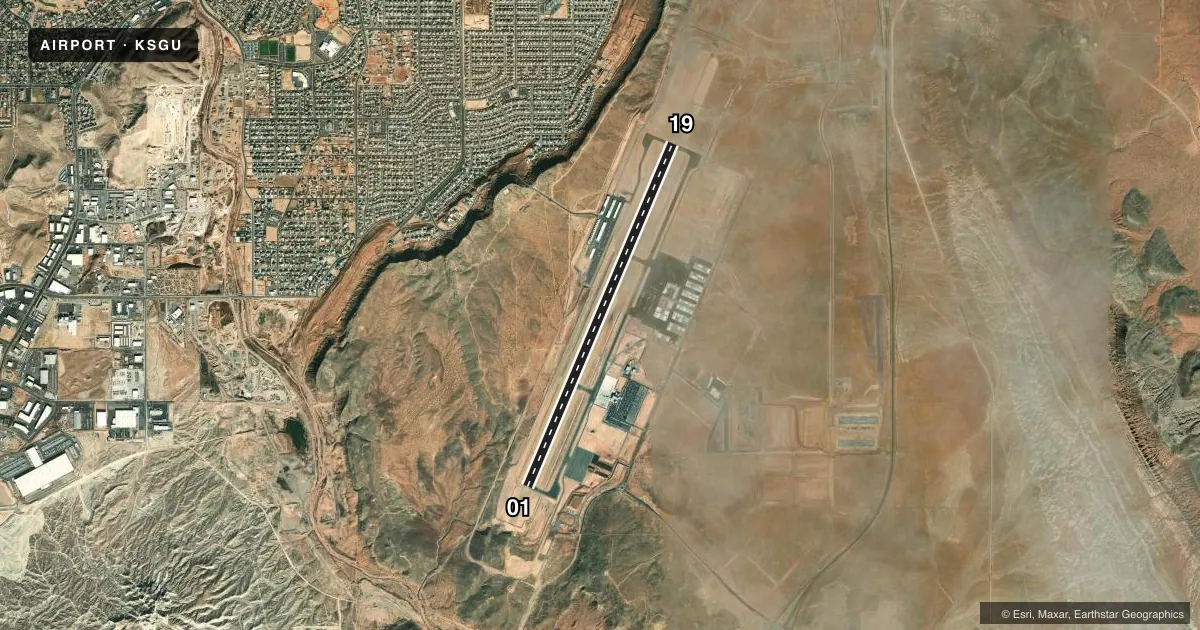
Airport sketch
Runways drawn to scale from FAA survey coordinates, rendered over satellite imagery. Not for navigation.
Approaches & charts
ILS · 1
Services on the field
Fuel grades, oxygen, maintenance, ramp storage and lighting — as declared to the FAA by the airport operator.
Fuel & services
- Fuel
- 100LLA
- Oxygen (bulk)
- Low pressure
- Airframe repair
- Major
- Power plant repair
- Major
- Other services
- AFRT,AMB,AVNCS,INSTR,RNTL,SALES
Ramp & ground
- Transient storage
- Tie-down
- Hangar
- Landing fee
- Yes
- Lighting schedule
- SEE RMK
- Beacon
- White / Green (civil land)(WG)
- Wind indicator
- Lighted
- Segmented circle
- Yes
Fuel & FBOs
Cheapest 100LL and Jet A on the field and nearby. Always confirm with the FBO before taxi.
Airport notes
Surface conditions, obstructions, local procedures, lighting outages and other notes published with each FAA cycle.
General notes
- PPR OVR 150000 LB - AMGR.
- COLD TEMPERATURE AIRPORT. ALTITUDE CORRECTION REQUIRED AT OR BELOW -5C.
- NO ACFT TKOFS/LNDGS ON UNPAVED/DIRT RWY SAFETY AREAS ADJ TO ALL RWYS.
- OFF RWY LNDGS NOT PMTD. CTAF INTRPN MAY OCCUR DUE TO AFLD CURVATURE BTN ALPHA 1 AND ALPHA 5.
- RWY 1/19, A, A1, A2, A4, A5 & TERM AVBL TO ACRS.
Lighting notes
- ACTVT MALSR RWY 19; REIL RWY 01; HIRL RWY 01/19 - CTAF. PAPI RWY 01 & 19 ON CONSLY.
Runway surface & condition
- 01/19PCR VALUE: 300/F/D/X/T
Approach & departure obstructions
- 19CALM WIND RWY.
Other notes
- ACFT +12500 LB.
VFR map & nearby airports
VFR sectional. Tap any ICAO chip to open that airport.
Key facts · KSGU
Answer card- ICAO
- KSGU
- Name
- ST GEORGE RGNL
- Location
- ST GEORGE, UTAH
- Elevation
- 2,883.6 ft MSL
- Traffic pattern altitude
- 3,883.6 ft MSL (1,000 AGL)
- Control tower
- Non-towered (use CTAF)
- Total runways
- 1
- Longest runway
- 01/19 · 9,300 ft
- Published ILS approaches
- 1
- Published frequencies
- 2
- Magnetic variation
- 12°
- Current flight rules
- VFR
- Current wind
- 090° at 5 kt
- Favored runway now
- RWY 01
St George Rgnl sits in St George, Utah. Field elevation is 2,883.6 ft MSL. The airport has one runway, 01/19, which is 9,300 ft long. There is no control tower. CTAF and UNICOM are both 123.075. The published pattern altitude is not given, so use the standard 1,000 ft AGL pattern unless the current Chart Supplement says otherwise.
Runway 19 has an ILS. The field also has MALSR on 19. REIL is on 01. High intensity runway lights are on both ends. Those lights are controlled by CTAF. The published remarks also say runway 19 is the calm wind runway. That matters here because the airport sits in a busy southern Utah corridor with high density altitude risk in warm weather. The field is also a cold temperature airport. Altitude correction is required at or below minus 5 degrees Celsius.
Sandstone Aviation is on the field. It carries 100LL, Jet A and Jet A Prist. Million Air St. George is also on the field. It carries 100LL, Jet A and Jet A Prist. Off runway landings are not permitted. The airport also notes CTAF interference may occur because of the airfield curvature between Alpha 1 and Alpha 5. Check the current Chart Supplement for any fee details, weight limits, or other operating limits before you go.