METAR & TAF 1L9
1L9 does not publish a METAR.
Showing the nearest reporting station: KCDC (CEDAR CITY RGNL) · 16.5 NM away. Conditions at 1L9 may differ.
METAR · KCDC
Observed 05:53Z
KCDC 270553Z AUTO 15008KT 10SM CLR 26/11 A3019 RMK AO2 SLP126 T02560106 10306 20256 50001
- Wind
- 150° @ 8 kt
- Visibility
- 10 SM
- Temp / Dew
- 26°C / 11°C
- Altimeter
- 30.19 inHg
- Clouds
- CLR
- Density alt
- 8,335 ft
- Ceiling
- Unlimited
- Rules
- VFR
Airport info & contacts
Manager on record, flight service, ARTCC, attendance schedule and pattern altitude — published by the FAA and refreshed every 28 days.
Location
- From city
- 1 NM NE
- VFR sectional
- LAS VEGAS
- ARTCC
- ZLC · SALT LAKE CITY
- NOTAM facility
- CDC (NOTAM-D)
Airport manager
- Name
- DAN JESSEN
- Phone
- 435-477-3331
- Address
- P.O. BOX 576, PAROWAN UT 84761
Flight service · Hours
- FSS CDC
- CEDAR CITY1-800-WX-BRIEF
- Attendance
- 0800-1700
Frequencies
Tap any row to copy the frequency to your clipboard.
Runways & pattern
Full pagePattern entry · RWY 22
RIGHT TRAFFICRunway end performance
| End | TORA | TODA | ASDA | LDA | VGSI | Approach lights | Obstruction |
|---|---|---|---|---|---|---|---|
| 04 | — | — | — | — | PAPI 2-box left(3°) | — | — |
| 22 | — | — | — | — | PAPI 2-box left(3°) | — | — |
Declared distances in feet. TORA = takeoff run available, TODA = takeoff distance, ASDA = accelerate-stop, LDA = landing distance.
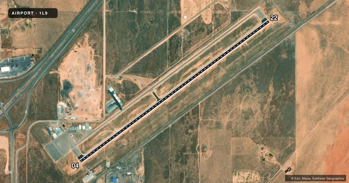
Airport sketch
Runways drawn to scale from FAA survey coordinates, rendered over satellite imagery. Not for navigation.
Approaches & charts
Services on the field
Fuel grades, oxygen, maintenance, ramp storage and lighting — as declared to the FAA by the airport operator.
Fuel & services
- Fuel
- 100LLA
- Oxygen (bottled)
- Not available
- Oxygen (bulk)
- HIGH/LOW
- Airframe repair
- Major
- Power plant repair
- Major
Ramp & ground
- Transient storage
- Tie-down
- Landing fee
- No fee published
- Customs
- Not available
- Lighting schedule
- SEE RMK
- Beacon schedule
- SS-SR
- Beacon
- White / Green (civil land)(WG)
- Wind indicator
- Lighted
- Segmented circle
- Yes
Fuel & FBOs
Cheapest 100LL and Jet A on the field and nearby. Always confirm with the FBO before taxi.
Airport notes
Surface conditions, obstructions, local procedures, lighting outages and other notes published with each FAA cycle.
General notes
- FOR CD CTC SALT LAKE ARTCC AT 801-320-2568.
- ROCKS IN TWY SAFETY AREAS UNSUITABLE FOR ACFT.
Lighting notes
- ACTVT & CHG INTST REIL RWY 04 & 22; MIRL RWY 04/22 - CTAF. PAPI RWY 04 & 22 ON CONSLY.
Approach & departure obstructions
- 04PAPI DOES NOT PRVD OBST CLNC BYD 2.3 NM FM RWY THR.
- 22PAPI DOES NOT PRVD OBST CLNC BYD 3.0 NM FM RWY THR.
Other notes
- EXISTED PRIOR TO 1959.
VFR map & nearby airports
VFR sectional. Tap any ICAO chip to open that airport.
Key facts · 1L9
Answer card- ICAO
- 1L9
- Name
- PAROWAN
- Location
- PAROWAN, UTAH
- Elevation
- 5,926.9 ft MSL
- Traffic pattern altitude
- 6,926.9 ft MSL (1,000 AGL)
- Control tower
- Non-towered (use CTAF)
- Total runways
- 1
- Longest runway
- 04/22 · 5,001 ft
- Published ILS approaches
- 0
- Published frequencies
- 2
- Magnetic variation
- 14°
- Current flight rules
- VFR
- Current wind
- 150° at 8 kt
- Favored runway now
- RWY 22
Parowan Airport sits in Parowan, Utah at 5,926.9 ft MSL. It has one runway, 04/22, which is 5,001 ft long and paved asphalt. The field is non-towered. CTAF and UNICOM are both 122.8. No ILS approaches are published here.
Pattern altitude is not published. For light piston operations, use the standard 1,000 ft AGL unless the current Chart Supplement or local procedures say otherwise. That puts the pattern at about 6,926.9 ft MSL. The airport sits high enough that density altitude deserves attention, especially on warm days. Expect takeoff and climb performance to be a real factor.
Parowan Aero Services is on the field. It carries 100LL and Jet A. Call (435) 477-8911 for current services before you go. Published remarks also note that rocks in the taxiway safety areas are not suitable for aircraft. The runway lighting is pilot-controlled on CTAF. REIL and MIRL on 04/22 are activated and intensity-controlled that way. PAPI on 04 and 22 runs continuously. The PAPI does not provide obstacle clearance beyond 2.3 NM from the runway 04 threshold or beyond 3.0 NM from the runway 22 threshold. For clearance delivery, contact Salt Lake ARTCC at 801-320-2568.