METAR & TAF KBCE
Current METAR
Observed 05:53Z
KBCE 270553Z AUTO 27004KT 10SM BKN110 19/11 A3038 RMK AO2 SLP138 60000 T01940106 10244 20189 50002
- Wind
- 270° @ 4 kt
- Visibility
- 10 SM
- Temp / Dew
- 19°C / 11°C
- Altimeter
- 30.38 inHg
- Clouds
- BKN
- Density alt
- 9,321 ft
- Ceiling
- 11,000 ft AGL
- Rules
- VFR
Airport info & contacts
Manager on record, flight service, ARTCC, attendance schedule and pattern altitude — published by the FAA and refreshed every 28 days.
Location
- From city
- 4 NM N
- VFR sectional
- LAS VEGAS
- ARTCC
- ZLC · SALT LAKE CITY
- NOTAM facility
- BCE (NOTAM-D)
Airport manager
- Name
- TYE RAMSAY
- Phone
- 435-834-5239
- Address
- 450 NORTH AIRPORT ROAD, PO BOX 640037, BRYCE UT 84764
Flight service · Hours
- FSS CDC
- CEDAR CITY1-800-WX-BRIEF
- Attendance
- 0800-1630
Frequencies
Tap any row to copy the frequency to your clipboard.
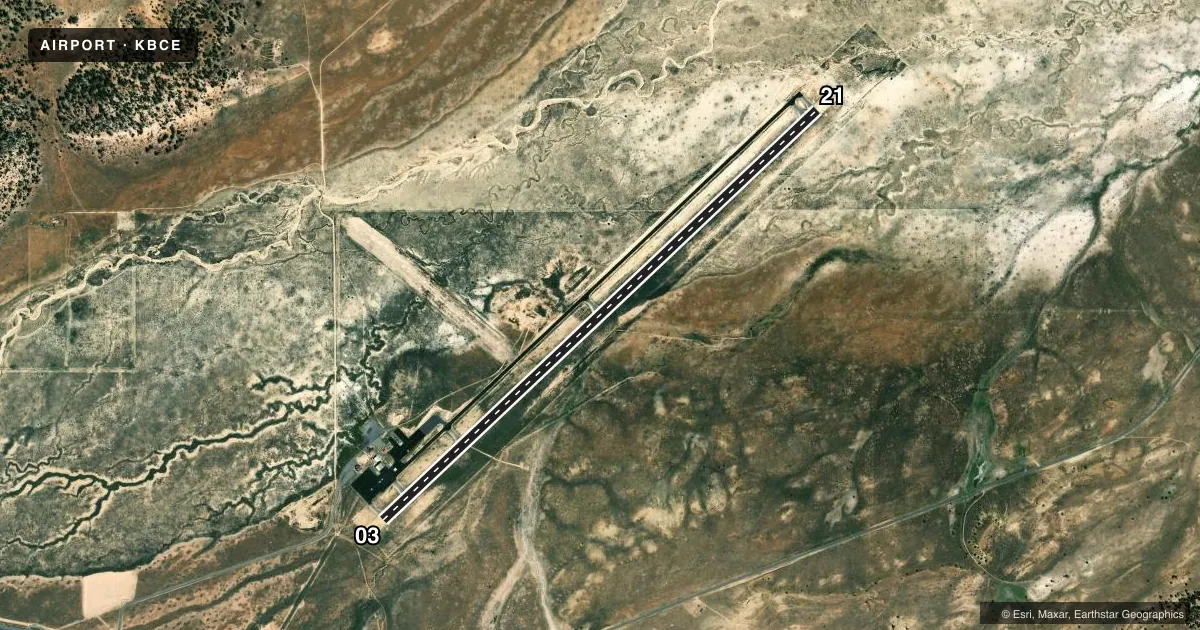
Runways & pattern
Full pagePattern entry · RWY 21
LEFT TRAFFICRunway end performance
| End | TORA | TODA | ASDA | LDA | VGSI | Approach lights | Obstruction |
|---|---|---|---|---|---|---|---|
| 03 | — | — | — | — | PAPI 2-box left(3°) | — | 13', road, 615' from thr, 133' R of cntrln, slope 30 |
| 21 | — | — | — | — | PAPI 2-box left(3°) | — | — |
Declared distances in feet. TORA = takeoff run available, TODA = takeoff distance, ASDA = accelerate-stop, LDA = landing distance.
Airport sketch
Runways drawn to scale from FAA survey coordinates, rendered over satellite imagery. Not for navigation.
Approaches & charts
Services on the field
Fuel grades, oxygen, maintenance, ramp storage and lighting — as declared to the FAA by the airport operator.
Fuel & services
- Fuel
- 100LLA
- Oxygen (bottled)
- Not available
- Oxygen (bulk)
- Not available
- Airframe repair
- Not available
- Power plant repair
- Not available
- Other services
- CHTR
Ramp & ground
- Transient storage
- Tie-down
- Landing fee
- No fee published
- Customs
- Not available
- Lighting schedule
- SEE RMK
- Beacon schedule
- SS-SR
- Beacon
- White / Green (civil land)(WG)
- Wind indicator
- Lighted
- Segmented circle
- Yes
Fuel & FBOs
Cheapest 100LL and Jet A on the field and nearby. Always confirm with the FBO before taxi.
Airport notes
Surface conditions, obstructions, local procedures, lighting outages and other notes published with each FAA cycle.
General notes
- FOR CD IF UNA TO CTC ON FSS FREQ, CTC SALT LAKE ARTCC AT 801-320-2568.
Lighting notes
- ACTVT REIL RWY 03 & 21; PAPI RWY 03 & 21; MIRL RWY 03/21 - CTAF.
Fuel notes
- 100LLAFT HRS FUEL CALL 435-690-9498. $50 CALL-IN FEE.
VFR map & nearby airports
VFR sectional. Tap any ICAO chip to open that airport.
Key facts · KBCE
Answer card- ICAO
- KBCE
- Name
- BRYCE CANYON
- Location
- BRYCE CANYON, UTAH
- Elevation
- 7,589.9 ft MSL
- Traffic pattern altitude
- 8,589.9 ft MSL (1,000 AGL)
- Control tower
- Non-towered (use CTAF)
- Total runways
- 1
- Longest runway
- 03/21 · 7,395 ft
- Published ILS approaches
- 0
- Published frequencies
- 2
- Magnetic variation
- 14°
- Current flight rules
- VFR
- Current wind
- 270° at 4 kt
- Favored runway now
- RWY 21
Bryce Canyon Airport sits in Bryce Canyon, Utah. Field elevation is 7,589.9 ft MSL. That altitude matters. Expect performance to change fast on warm days. The airport has one runway. Runway 03/21 is 7,395 ft long with asphalt pavement. No tower is published, so use CTAF 122.8 for traffic calls. Pattern altitude is not published. Use the standard 1,000 ft AGL pattern for light piston unless the current Chart Supplement says otherwise. That puts you at about 8,590 ft MSL.
No ILS approaches are published here. Plan for non-precision or visual work only, then verify the current procedure set before you go. The on-field FBO is Bryce Canyon Airport. It carries 100LL, Jet A and Jet A Prist. After hours fuel is available by phone. A published call-in fee applies. Runway end identifier lights, PAPI and medium intensity runway lights are installed on 03 and 21. That helps for night arrivals. The elevation and terrain still deserve respect. Clearance delivery may need a call to Salt Lake Center if flight service cannot be reached. For a first trip, brief the density altitude, runway lighting and the lack of tower control before you launch.