METAR & TAF 1L7
1L7 does not publish a METAR.
Showing the nearest reporting station: KBCE (BRYCE CANYON) · 27.4 NM away. Conditions at 1L7 may differ.
METAR · KBCE
Observed 09:53Z
KBCE 270953Z AUTO 27006KT 10SM OVC100 16/11 A3036 RMK AO2 SLP146 T01610111
- Wind
- 270° @ 6 kt
- Visibility
- 10 SM
- Temp / Dew
- 16°C / 11°C
- Altimeter
- 30.36 inHg
- Clouds
- OVC
- Density alt
- 6,688 ft
- Ceiling
- 10,000 ft AGL
- Rules
- VFR
Airport info & contacts
Manager on record, flight service, ARTCC, attendance schedule and pattern altitude — published by the FAA and refreshed every 28 days.
Location
- From city
- 2 NM SE
- VFR sectional
- LAS VEGAS
- ARTCC
- ZLC · SALT LAKE CITY
- NOTAM facility
- CDC (NOTAM-D)
Airport manager
- Name
- LENZA WILSON
- Phone
- 435-690-9146
- Address
- PO BOX 189, ESCALANTE UT 84726
Flight service · Hours
- FSS CDC
- CEDAR CITY1-800-WX-BRIEF
- Attendance
- Unattended
Frequencies
Tap any row to copy the frequency to your clipboard.
Runways & pattern
Full pagePattern entry · RWY 31
LEFT TRAFFICRunway end performance
| End | TORA | TODA | ASDA | LDA | VGSI | Approach lights | Obstruction |
|---|---|---|---|---|---|---|---|
| 13 | — | — | — | — | PAPI 2-box left(3°) | — | — |
| 31 | — | — | — | — | PAPI 2-box left(3°) | — | — |
Declared distances in feet. TORA = takeoff run available, TODA = takeoff distance, ASDA = accelerate-stop, LDA = landing distance.
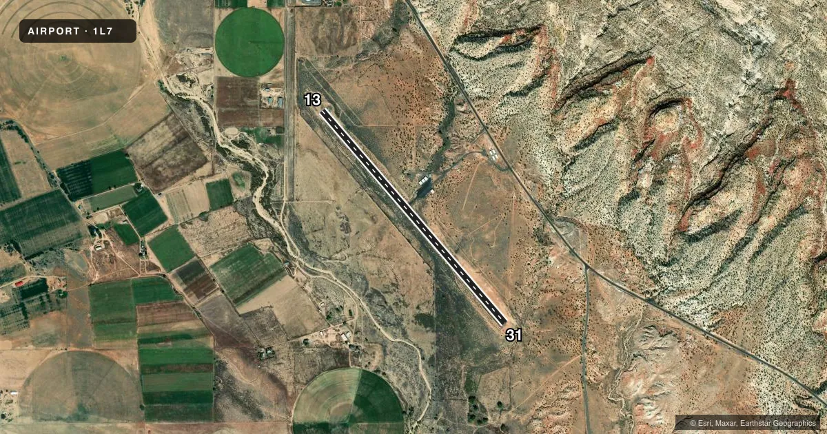
Airport sketch
Runways drawn to scale from FAA survey coordinates, rendered over satellite imagery. Not for navigation.
Approaches & charts
Services on the field
Fuel grades, oxygen, maintenance, ramp storage and lighting — as declared to the FAA by the airport operator.
Fuel & services
- Fuel
- 100LL
- Oxygen (bottled)
- Not available
- Oxygen (bulk)
- Not available
- Airframe repair
- Not available
- Power plant repair
- Not available
Ramp & ground
- Transient storage
- Tie-down
- Landing fee
- No fee published
- Customs
- Not available
- Lighting schedule
- SEE RMK
- Beacon schedule
- SS-SR
- Beacon
- White / Green (civil land)(WG)
- Wind indicator
- Lighted
- Segmented circle
- Yes
Fuel & FBOs
Cheapest 100LL and Jet A on the field and nearby. Always confirm with the FBO before taxi.
Airport notes
Surface conditions, obstructions, local procedures, lighting outages and other notes published with each FAA cycle.
General notes
- FOR CD CTC SALT LAKE ARTCC AT 801-320-2568.
Lighting notes
- ACTVT MIRL RY 13/31 - CTAF.
Other notes
- THIS AIRPORT HAS BEEN SURVEYED BY THE NATIONAL GEODETIC SURVEY.
VFR map & nearby airports
VFR sectional. Tap any ICAO chip to open that airport.
Key facts · 1L7
Answer card- ICAO
- 1L7
- Name
- ESCALANTE MUNI
- Location
- ESCALANTE, UTAH
- Elevation
- 5,736.9 ft MSL
- Traffic pattern altitude
- 6,736.9 ft MSL (1,000 AGL)
- Control tower
- Non-towered (use CTAF)
- Total runways
- 1
- Longest runway
- 13/31 · 5,032 ft
- Published ILS approaches
- 0
- Published frequencies
- 2
- Magnetic variation
- 10°
- Current flight rules
- VFR
- Current wind
- 270° at 6 kt
- Favored runway now
- RWY 31
Escalante Muni sits in Escalante, Utah. The field elevation is 5,736.9 ft MSL. It has one runway. Runway 13/31 is 5,032 ft long with asphalt pavement. The airport is non-towered, so use CTAF 122.8 for self-announce traffic and runway light activation. Medium intensity runway lights on 13/31 are activated through the common traffic advisory frequency. No ILS approaches are published here.
Pattern altitude is not published. Use 1,000 ft AGL for light piston operations unless the current Chart Supplement says otherwise. GateOne, formerly Sphere One Aviation, is on the field. It carries 100LL. Call (435) 586-4504 before arrival if you need current service details. The airport has been surveyed by the National Geodetic Survey.
This is a high-elevation field in southern Utah. Expect performance to matter. Density altitude can run high in warm weather. Plan your takeoff and landing distances with margin. For clearance delivery, contact Salt Lake ARTCC at 801-320-2568. If you need current noise, airspace, or procedure details, check the current FAA Chart Supplement before you go.