METAR & TAF 38U
38U does not publish a METAR.
Showing the nearest reporting station: KRIF (RICHFIELD MUNI) · 32.6 NM away. Conditions at 38U may differ.
METAR · KRIF
Observed 20:34Z
KRIF 262034Z AUTO 14007KT 10SM CLR 34/09 A3014 RMK AO2
- Wind
- 140° @ 7 kt
- Visibility
- 10 SM
- Temp / Dew
- 34°C / 9°C
- Altimeter
- 30.14 inHg
- Clouds
- CLR
- Density alt
- 10,721 ft
- Ceiling
- Unlimited
- Rules
- VFR
Airport info & contacts
Manager on record, flight service, ARTCC, attendance schedule and pattern altitude — published by the FAA and refreshed every 28 days.
Location
- From city
- 3 NM SE
- VFR sectional
- LAS VEGAS
- ARTCC
- ZLC · SALT LAKE CITY
- NOTAM facility
- CDC (NOTAM-D)
Airport manager
- Name
- FELICIA SNOW
- Phone
- (435) 836-1300
- Address
- 18 S MAIN, LOA UT 84747
Flight service · Hours
- FSS CDC
- CEDAR CITY1-800-WX-BRIEF
- Attendance
- Unattended
Frequencies
Tap any row to copy the frequency to your clipboard.
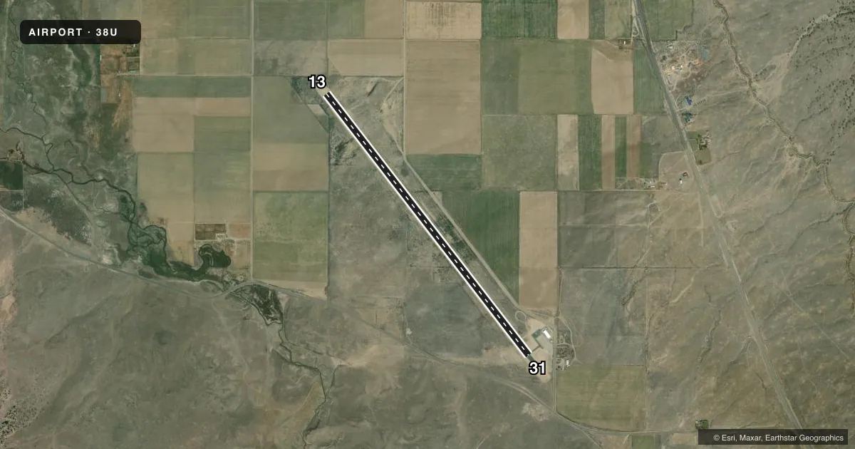
Runways & pattern
Full pagePattern entry · RWY 13
LEFT TRAFFICAirport sketch
Runways drawn to scale from FAA survey coordinates, rendered over satellite imagery. Not for navigation.
Approaches & charts
Services on the field
Fuel grades, oxygen, maintenance, ramp storage and lighting — as declared to the FAA by the airport operator.
Fuel & services
- Fuel
- 100LL
- Oxygen (bottled)
- Not available
- Oxygen (bulk)
- Not available
- Airframe repair
- Not available
- Power plant repair
- Not available
Ramp & ground
- Transient storage
- Tie-down
- Landing fee
- No fee published
- Customs
- Not available
- Lighting schedule
- SEE RMK
- Beacon schedule
- SS-SR
- Beacon
- White / Green (civil land)(WG)
- Wind indicator
- Lighted
- Segmented circle
- Yes
Fuel & FBOs
Cheapest 100LL and Jet A on the field and nearby. Always confirm with the FBO before taxi.
Airport notes
Surface conditions, obstructions, local procedures, lighting outages and other notes published with each FAA cycle.
General notes
- FOR CD CTC SALT LAKE ARTCC AT 801-320-2568.
Lighting notes
- ACTVT MIRL RWY 13/31 - CTAF.
Fuel notes
- 100LLFOR FUEL CALL AMGR 435-836-1300.
VFR map & nearby airports
VFR sectional. Tap any ICAO chip to open that airport.
Key facts · 38U
Answer card- ICAO
- 38U
- Name
- WAYNE WONDERLAND
- Location
- LOA, UTAH
- Elevation
- 7,027.4 ft MSL
- Traffic pattern altitude
- 8,027.4 ft MSL (1,000 AGL)
- Control tower
- Non-towered (use CTAF)
- Total runways
- 1
- Longest runway
- 13/31 · 5,693 ft
- Published ILS approaches
- 0
- Published frequencies
- 1
- Magnetic variation
- 14°
- Current flight rules
- VFR
- Current wind
- 140° at 7 kt
- Favored runway now
- RWY 13
Wayne Wonderland Airport (38U) sits in Loa, Utah. The field elevation is 7,027.4 ft MSL. It has one runway. Runway 13/31 is 5,693 ft long with an asphalt surface. The airport is not towered. CTAF is 122.9.
No ILS approaches are published here. The published pattern altitude is not listed, so use the standard 1,000 ft AGL pattern unless local procedures or current Chart Supplement remarks say otherwise. For this field that works out to about 8,027.4 ft MSL. The runway lights on 13/31 are medium intensity. They are activated by the CTAF.
Wonderland Airport is on the field. It carries 100LL. Call the airport manager at 435-836-1300 for fuel details before you go. For clearance delivery, contact Salt Lake ARTCC at 801-320-2568. At 7,000-plus feet MSL, expect high-density-altitude performance to matter on warm days. Plan your climb and takeoff margins with that in mind. If you are new to the area, get current runway and lighting details from the Chart Supplement before departure.