METAR & TAF 44U
44U does not publish a METAR.
Showing the nearest reporting station: KRIF (RICHFIELD MUNI) · 21.6 NM away. Conditions at 44U may differ.
METAR · KRIF
Observed 06:15Z
KRIF 270615Z AUTO 20005KT 10SM -RA FEW022 OVC047 25/13 A3018 RMK AO2
- Wind
- 200° @ 5 kt
- Visibility
- 10 SM
- Temp / Dew
- 25°C / 13°C
- Altimeter
- 30.18 inHg
- Clouds
- OVC
- Density alt
- 7,275 ft
- Ceiling
- 4,700 ft AGL
- Rules
- VFR
Airport info & contacts
Manager on record, flight service, ARTCC, attendance schedule and pattern altitude — published by the FAA and refreshed every 28 days.
Location
- From city
- 5 NM NE
- VFR sectional
- LAS VEGAS
- ARTCC
- ZLC · SALT LAKE CITY
- NOTAM facility
- CDC (NOTAM-D)
Airport manager
- Name
- RICHARD NAY
- Phone
- (435) 979-9234
- Address
- 90 N 200 W, SALINA UT 84654
Flight service · Hours
- FSS CDC
- CEDAR CITY1-800-WX-BRIEF
- Attendance
- Unattended
Frequencies
Tap any row to copy the frequency to your clipboard.
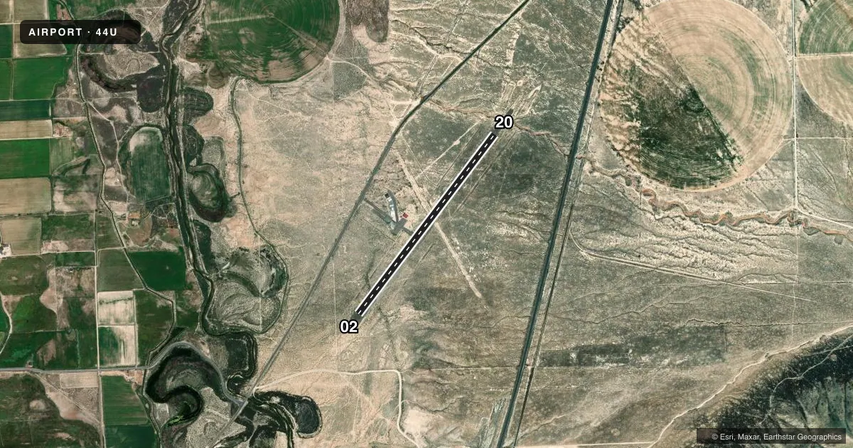
Runways & pattern
Full pagePattern entry · RWY 20
LEFT TRAFFICAirport sketch
Runways drawn to scale from FAA survey coordinates, rendered over satellite imagery. Not for navigation.
Approaches & charts
Services on the field
Fuel grades, oxygen, maintenance, ramp storage and lighting — as declared to the FAA by the airport operator.
Fuel & services
- Fuel
- Not available
- Oxygen (bottled)
- Not available
- Oxygen (bulk)
- Not available
- Airframe repair
- Not available
- Power plant repair
- Not available
Ramp & ground
- Transient storage
- Tie-down
- Landing fee
- No fee published
- Customs
- Not available
- Lighting schedule
- SEE RMK
- Beacon schedule
- SS-SR
- Beacon
- White / Green (civil land)(WG)
- Wind indicator
- No
- Segmented circle
- No
Fuel & FBOs
Cheapest 100LL and Jet A on the field and nearby. Always confirm with the FBO before taxi.
Airport notes
Surface conditions, obstructions, local procedures, lighting outages and other notes published with each FAA cycle.
General notes
- FOR CD CTC SALT LAKE ARTCC AT 801-320-2568.
Lighting notes
- ACTVT MIRL RY 02/20 - CTAF.
Other notes
- ESTABD PRIOR TO 1959.
VFR map & nearby airports
VFR sectional. Tap any ICAO chip to open that airport.
Key facts · 44U
Answer card- ICAO
- 44U
- Name
- SALINA-GUNNISON
- Location
- SALINA, UTAH
- Elevation
- 5,159 ft MSL
- Traffic pattern altitude
- 6,159 ft MSL (1,000 AGL)
- Control tower
- Non-towered (use CTAF)
- Total runways
- 1
- Longest runway
- 02/20 · 3,855 ft
- Published ILS approaches
- 0
- Published frequencies
- 1
- Magnetic variation
- 14°
- Current flight rules
- VFR
- Current wind
- 200° at 5 kt
- Favored runway now
- RWY 20
Salina-Gunnison is in Salina, Utah. The field elevation is 5,159 ft MSL. It has one runway. Runway 02/20 is 3,855 ft long with an asphalt surface. There is no control tower. CTAF is 122.9. No ILS approaches are published here.
Pattern altitude is not published in the facts, so use the standard 1,000 ft AGL pattern unless the current FAA Chart Supplement says otherwise. That puts the light aircraft pattern at 6,159 ft MSL based on the field elevation. The airport sits in central Utah at higher elevation, so performance planning matters on warm days and with a full load.
Published remarks say the runway lights on 02/20 are medium intensity and are activated by using the common traffic advisory frequency. The airport was established prior to 1959. For clearance delivery, contact Salt Lake ARTCC at 801-320-2568. No on-field FBOs are listed, so verify services with the airport operator or call the field on CTAF before you go.