METAR & TAF 69V
69V does not publish a METAR.
Showing the nearest reporting station: KPUC (CARBON COUNTY RGNL/BUCK DAVIS FLD) · 17.0 NM away. Conditions at 69V may differ.
METAR · KPUC
Observed 05:53Z
KPUC 270553Z AUTO 19010KT 10SM OVC100 28/09 A3023 RMK AO2 SLP095 T02830094 10367 20283 51020 $
- Wind
- 190° @ 10 kt
- Visibility
- 10 SM
- Temp / Dew
- 28°C / 9°C
- Altimeter
- 30.23 inHg
- Clouds
- OVC
- Density alt
- 8,511 ft
- Ceiling
- 10,000 ft AGL
- Rules
- VFR
Airport info & contacts
Manager on record, flight service, ARTCC, attendance schedule and pattern altitude — published by the FAA and refreshed every 28 days.
Location
- From city
- 3 NM NE
- VFR sectional
- DENVER
- ARTCC
- ZLC · SALT LAKE CITY
- NOTAM facility
- CDC (NOTAM-D)
Airport manager
- Name
- JEFF GUYMON
- Phone
- 435-381-3589
- Address
- 75 E MAIN ST., PO BOX 907, CASTLE DALE UT 84513
Flight service · Hours
- FSS CDC
- CEDAR CITY1-800-WX-BRIEF
- Attendance
- UNATTENDED
Frequencies
Tap any row to copy the frequency to your clipboard.
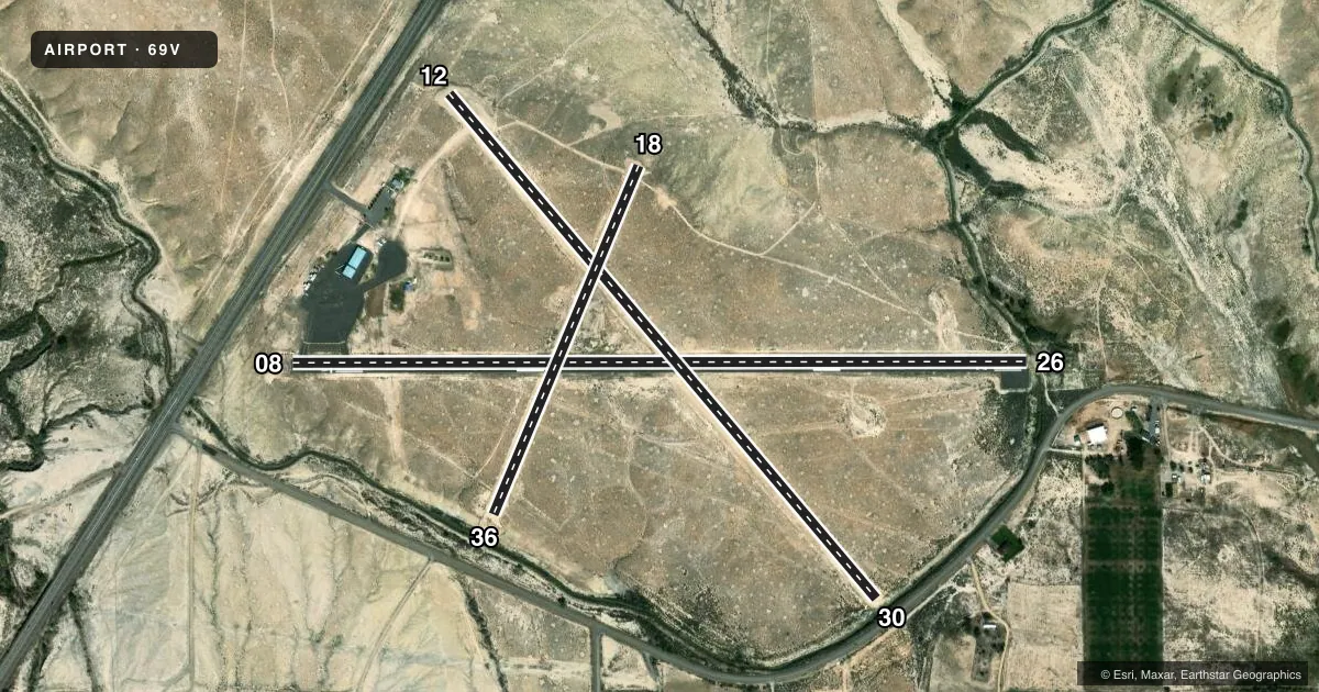
Runways & pattern
Full pagePattern entry · RWY 18
LEFT TRAFFIC| Runway | Heading (°M) | Length | Surface | Traffic |
|---|---|---|---|---|
| 08/26 | 76° / 256° | 4,048 ft | ASPH | Standard L |
| 12/30 | 126° / 306° | 3,640 ft | DIRT | Standard L |
| 18/36Favored | 189° / 9° | 2,079 ft | DIRT | Standard L |
Runway end performance
| End | TORA | TODA | ASDA | LDA | VGSI | Approach lights | Obstruction |
|---|---|---|---|---|---|---|---|
| 08 | — | — | — | — | — | — | 10', road, 270' from thr, 269' R of cntrln, slope 7 |
| 26 | — | — | — | — | — | — | 15', trees, 210' from thr, 154' R of cntrln, slope 0 |
| 12 | — | — | — | — | — | — | 13', fence, 110' from thr, 0' R of cntrln, slope 8 |
| 30 | — | — | — | — | — | — | 22', trees, 50' from thr, 70' R of cntrln, slope 2 |
Declared distances in feet. TORA = takeoff run available, TODA = takeoff distance, ASDA = accelerate-stop, LDA = landing distance.
Airport sketch
Runways drawn to scale from FAA survey coordinates, rendered over satellite imagery. Not for navigation.
Approaches & charts
Services on the field
Fuel grades, oxygen, maintenance, ramp storage and lighting — as declared to the FAA by the airport operator.
Fuel & services
- Fuel
- 100LL
- Oxygen (bottled)
- Not available
- Oxygen (bulk)
- Not available
- Airframe repair
- Not available
- Power plant repair
- Not available
- Other services
- INSTR
Ramp & ground
- Transient storage
- Tie-down
- Landing fee
- No fee published
- Customs
- Not available
- Lighting schedule
- SEE RMK
- Beacon schedule
- SS-SR
- Beacon
- White / Green (civil land)(WG)
- Wind indicator
- Lighted
- Segmented circle
- Yes
Fuel & FBOs
Cheapest 100LL and Jet A on the field and nearby. Always confirm with the FBO before taxi.
Airport notes
Surface conditions, obstructions, local procedures, lighting outages and other notes published with each FAA cycle.
General notes
- RY 08/26 NO LINE OF SIGHT BTN RY ENDS.
- FOR CD CTC SALT LAKE ARTCC AT 801-320-2568.
Lighting notes
- ACTVT MIRL RY 08/26 - CTAF.
Fuel notes
- 100LLFUEL 24 HR SELF SERVE.
Approach & departure obstructions
- 2615 FT TREES, 20 FT DSTC, 70 FT R.
- 08APCH SLOPE 48:1 TO DTHR.
- 1815 FT DROP OFF AT RWY 18 END.
- 3615 FT DROP OFF AT RWY 36 END.
- 12MARKED PLINE 360' FROM END RWY.
Other notes
- EXISTED PRIOR TO 1959.
- LCL WX AVBL CTAF 122.8 , 3 CLICKS.
- 12/30SMALL AMOUNTS OF VEGETATION ON RUNWAY 12/30.
- 18/36SMALL AMOUNTS OF VEGETATION ON RUNWAY 18/36.
VFR map & nearby airports
VFR sectional. Tap any ICAO chip to open that airport.
Key facts · 69V
Answer card- ICAO
- 69V
- Name
- HUNTINGTON MUNI
- Location
- HUNTINGTON, UTAH
- Elevation
- 5,915.3 ft MSL
- Traffic pattern altitude
- 6,915.3 ft MSL (1,000 AGL)
- Control tower
- Non-towered (use CTAF)
- Total runways
- 3
- Longest runway
- 08/26 · 4,048 ft
- Published ILS approaches
- 0
- Published frequencies
- 2
- Magnetic variation
- 14°
- Current flight rules
- VFR
- Current wind
- 190° at 10 kt
- Favored runway now
- RWY 18
Huntington Muni sits in Huntington, Utah at 5,915.3 ft MSL. It has three runways. The longest is 08/26 at 4,048 ft. This is a non-towered field, so use CTAF 122.8 for traffic calls. Use UNICOM for local weather by three clicks. The published pattern altitude is not listed, so use the standard 1,000 ft AGL for light piston operations unless the current Chart Supplement says otherwise. No ILS approaches are published here.
The on-field FBO is Huntington Municipal Airport. It carries 100LL. Fuel is 24-hour self-serve. That matters at this elevation because performance will be more limited than at a low field, especially on warm days. Runway 08/26 has medium intensity lights that are activated by CTAF. The strip also has some operational notes to keep in mind. There are trees near the 26 end. There is a marked power line near the 12 end. Vegetation is on 12/30 and 18/36. There is a drop-off at the 18 and 36 ends. Runway 08/26 also has no line of sight between runway ends. For clearance delivery, contact Salt Lake ARTCC at 801-320-2568. Check the current Chart Supplement before you go for any updates on runway condition or local procedures.