METAR & TAF U14
Current METAR
Observed 12:15Z
KU14 271215Z AUTO 20007KT 10SM CLR 24/11 A3011 RMK AO2
- Wind
- 200° @ 7 kt
- Visibility
- 10 SM
- Temp / Dew
- 24°C / 11°C
- Altimeter
- 30.11 inHg
- Clouds
- CLR
- Density alt
- 7,072 ft
- Ceiling
- Unlimited
- Rules
- VFR
Airport info & contacts
Manager on record, flight service, ARTCC, attendance schedule and pattern altitude — published by the FAA and refreshed every 28 days.
Location
- From city
- 3 NM NW
- VFR sectional
- LAS VEGAS
- ARTCC
- ZLC · SALT LAKE CITY
- NOTAM facility
- CDC (NOTAM-D)
Airport manager
- Name
- SCOTT NOLL
- Phone
- 435-262-9669
- Address
- 915 N. AIRPORT RD, NEPHI UT 84648
Flight service · Hours
- FSS CDC
- CEDAR CITY1-800-WX-BRIEF
- Attendance
- UNATNND
Frequencies
Tap any row to copy the frequency to your clipboard.
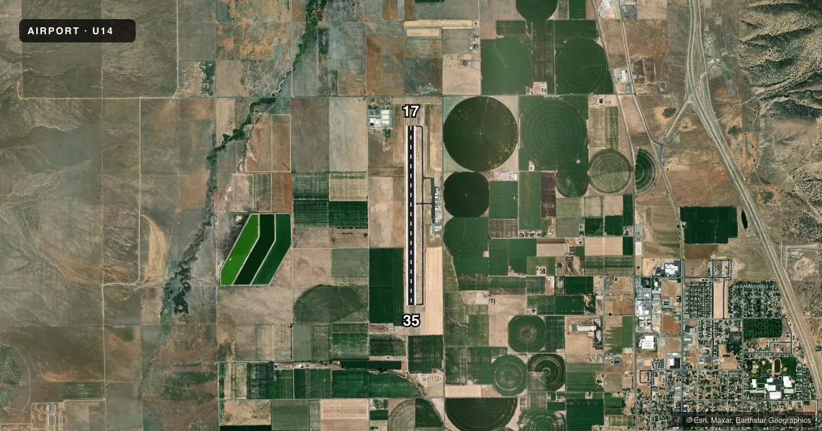
Runways & pattern
Full pagePattern entry · RWY 17
LEFT TRAFFICRunway end performance
| End | TORA | TODA | ASDA | LDA | VGSI | Approach lights | Obstruction |
|---|---|---|---|---|---|---|---|
| 17 | — | — | — | — | PAPI 2-box left(3°) | — | — |
| 35 | — | — | — | — | PAPI 2-box left(3°) | — | — |
Declared distances in feet. TORA = takeoff run available, TODA = takeoff distance, ASDA = accelerate-stop, LDA = landing distance.
Airport sketch
Runways drawn to scale from FAA survey coordinates, rendered over satellite imagery. Not for navigation.
Approaches & charts
Services on the field
Fuel grades, oxygen, maintenance, ramp storage and lighting — as declared to the FAA by the airport operator.
Fuel & services
- Fuel
- 100LLA
- Oxygen (bottled)
- Not available
- Oxygen (bulk)
- Not available
- Airframe repair
- Not available
- Power plant repair
- Not available
- Other services
- GLD,PAJA
Ramp & ground
- Transient storage
- Tie-down
- Landing fee
- No fee published
- Customs
- Not available
- Lighting schedule
- SEE RMK
- Beacon schedule
- SS-SR
- Beacon
- White / Green (civil land)(WG)
- Wind indicator
- Lighted
- Segmented circle
- Yes
Fuel & FBOs
Cheapest 100LL and Jet A on the field and nearby. Always confirm with the FBO before taxi.
Airport notes
Surface conditions, obstructions, local procedures, lighting outages and other notes published with each FAA cycle.
General notes
- GLDR OPS ON AND INVOF ARPT APR-NOV. 1000 - SS.
- FOR CD CTC SALT LAKE ARTCC AT 801-320-2568.
- PRCHT ACTVT SFC - 18,000 FT MAR-NOV SR-SS.
Lighting notes
- ACTVT REIL RWY 17 & 35; PAPI RWY 17 & 35; MIRL RWY 17/35 - CTAF.
Fuel notes
- A24 HR SELF SVC.
VFR map & nearby airports
VFR sectional. Tap any ICAO chip to open that airport.
Key facts · U14
Answer card- ICAO
- U14
- Name
- NEPHI MUNI
- Location
- NEPHI, UTAH
- Elevation
- 5,022.1 ft MSL
- Traffic pattern altitude
- 6,022.1 ft MSL (1,000 AGL)
- Control tower
- Non-towered (use CTAF)
- Total runways
- 1
- Longest runway
- 17/35 · 6,300 ft
- Published ILS approaches
- 0
- Published frequencies
- 2
- Magnetic variation
- 12°
- Current flight rules
- VFR
- Current wind
- 200° at 7 kt
- Favored runway now
- RWY 17
Nephi Muni sits in Nephi, Utah. The field elevation is 5,022.1 ft MSL. It has one runway, 17/35, which is 6,300 ft long and paved. There is no control tower. CTAF and UNICOM are both 123.075. No ILS approaches are published here.
Pattern altitude is not published, so use the standard 1,000 ft AGL for light piston operations unless the current Chart Supplement says otherwise. Runway 17 and 35 have runway end identifier lights. PAPI is available on both ends. Medium intensity runway lights are on runway 17/35 and are controlled by CTAF. That makes night work more straightforward. You still want to verify the lighting setup before departure.
Nephi Jet Center is on the field. It carries 100LL and Jet A. There is also 24-hour self-service fuel available. For clearance delivery, contact Salt Lake ARTCC. One thing to plan for here is mixed activity. Gliders operate from April through November between 1000 and sunset. Parachute activity also occurs on the surface up to 18,000 feet from March through November between sunrise and sunset. Expect a busy sky during those seasons. The airport is in high terrain country at over 5,000 ft MSL, so density altitude can matter a lot on warm days. Check performance before you go.