METAR & TAF KDTA
Current METAR
Observed 12:15Z
KDTA 271215Z AUTO 17014KT 10SM CLR 25/08 A3008 RMK AO1
- Wind
- 170° @ 14 kt
- Visibility
- 10 SM
- Temp / Dew
- 25°C / 8°C
- Altimeter
- 30.08 inHg
- Clouds
- CLR
- Density alt
- 6,904 ft
- Ceiling
- Unlimited
- Rules
- VFR
Airport info & contacts
Manager on record, flight service, ARTCC, attendance schedule and pattern altitude — published by the FAA and refreshed every 28 days.
Location
- From city
- 3 NM NE
- VFR sectional
- LAS VEGAS
- ARTCC
- ZLC · SALT LAKE CITY
- NOTAM facility
- CDC (NOTAM-D)
Airport manager
- Name
- JUSTIN ASHBY
- Phone
- 435-864-2759
- Address
- 76 NORTH 200 WEST, DELTA UT 84624-9440
Flight service · Hours
- FSS CDC
- CEDAR CITY1-800-WX-BRIEF
- Attendance
- Unattended
Frequencies
Tap any row to copy the frequency to your clipboard.
Runways & pattern
Full pagePattern entry · RWY 17
LEFT TRAFFICRunway end performance
| End | TORA | TODA | ASDA | LDA | VGSI | Approach lights | Obstruction |
|---|---|---|---|---|---|---|---|
| 17 | — | — | — | — | PAPI 2-box left(3°) | — | — |
| 35 | — | — | — | — | PAPI 2-box left(3°) | — | — |
Declared distances in feet. TORA = takeoff run available, TODA = takeoff distance, ASDA = accelerate-stop, LDA = landing distance.
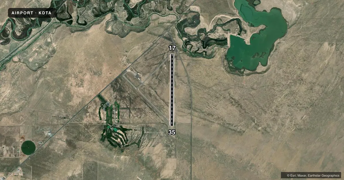
Airport sketch
Runways drawn to scale from FAA survey coordinates, rendered over satellite imagery. Not for navigation.
Approaches & charts
Services on the field
Fuel grades, oxygen, maintenance, ramp storage and lighting — as declared to the FAA by the airport operator.
Fuel & services
- Fuel
- 100LLA
- Oxygen (bottled)
- Not available
- Oxygen (bulk)
- Not available
- Airframe repair
- Not available
- Power plant repair
- Not available
Ramp & ground
- Transient storage
- Tie-down
- Landing fee
- No fee published
- Customs
- Not available
- Lighting schedule
- SEE RMK
- Beacon schedule
- SS-SR
- Beacon
- White / Green (civil land)(WG)
- Wind indicator
- Lighted
- Segmented circle
- Yes
Fuel & FBOs
Cheapest 100LL and Jet A on the field and nearby. Always confirm with the FBO before taxi.
Airport notes
Surface conditions, obstructions, local procedures, lighting outages and other notes published with each FAA cycle.
General notes
- FOR CD IF UNA TO CTC ON FSS FREQ, CTC SALT LAKE ARTCC AT 801-320-2568.
Lighting notes
- ACTVT REIL RWY 17& 35; PAPI RWY 17 & 35; MIRL RWY 17/35 - CTAF.
Fuel notes
- 100LL24 HR SELF SVC.
VFR map & nearby airports
VFR sectional. Tap any ICAO chip to open that airport.
Key facts · KDTA
Answer card- ICAO
- KDTA
- Name
- DELTA MUNI
- Location
- DELTA, UTAH
- Elevation
- 4,759.6 ft MSL
- Traffic pattern altitude
- 5,759.6 ft MSL (1,000 AGL)
- Control tower
- Non-towered (use CTAF)
- Total runways
- 1
- Longest runway
- 17/35 · 6,065 ft
- Published ILS approaches
- 0
- Published frequencies
- 2
- Magnetic variation
- 11°
- Current flight rules
- VFR
- Current wind
- 170° at 14 kt
- Favored runway now
- RWY 17
Delta Muni sits in Delta, Utah. The field elevation is 4,759.6 ft MSL. It has one runway. Runway 17/35 is 6,065 ft long with asphalt pavement. There is no control tower. CTAF and UNICOM are both 122.8. No ILS approaches are published here.
The pattern altitude is not published. For light piston work, use 1,000 ft AGL unless the current Chart Supplement says otherwise. Delta City is on the field. It carries 100LL and Jet A. 100LL is available 24 hours by self-serve. Runway 17 and 35 have runway end identifier lights. They also have PAPI. The runway has medium intensity lights, so night operations are supported.
This is a high-elevation airport, so density altitude can matter on warm days. Expect longer takeoff rolls and reduced climb performance. Use the published CTAF and keep an eye on the field elevation when planning performance. If you need clearance delivery and cannot reach flight service, the published remark says to contact Salt Lake ARTCC. Check the current Chart Supplement for any noise or operating notes before you go.