METAR & TAF KPVU
Current METAR
Observed 05:56Z
KPVU 270556Z AUTO 16007KT 10SM CLR 32/09 A3004 RMK AO2 SLP094 T03220094 10389 20311 403940206 50008
- Wind
- 160° @ 7 kt
- Visibility
- 10 SM
- Temp / Dew
- 32°C / 9°C
- Altimeter
- 30.04 inHg
- Clouds
- CLR
- Density alt
- 7,467 ft
- Ceiling
- Unlimited
- Rules
- VFR
Airport info & contacts
Manager on record, flight service, ARTCC, attendance schedule and pattern altitude — published by the FAA and refreshed every 28 days.
Location
- From city
- 2 NM SW
- VFR sectional
- SALT LAKE CITY
- ARTCC
- ZLC · SALT LAKE CITY
- NOTAM facility
- PVU (NOTAM-D)
Airport manager
- Name
- BRIAN TORGERSEN
- Phone
- 801-852-6720
- Address
- P. O. BOX 1849, PROVO UT 84603
Flight service · Hours
- FSS CDC
- CEDAR CITY1-800-WX-BRIEF
- Attendance
- NOV-MAY · 0600-2100
- JUN-OCT · 0600-2200
Frequencies
Tap any row to copy the frequency to your clipboard.
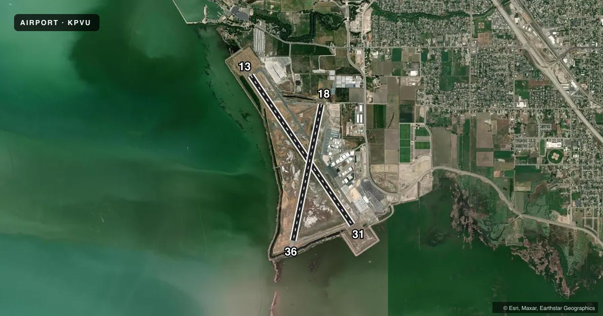
Runways & pattern
Full pagePattern entry · RWY 13
RIGHT TRAFFIC| Runway | Heading (°M) | Length | Surface | Traffic |
|---|---|---|---|---|
| 13/31Favored | 134° / 314° | 8,603 ft | ASPH | 13 R |
| 18/36 | 180° / 0° | 6,628 ft | ASPH | 18 R |
Runway end performance
| End | TORA | TODA | ASDA | LDA | VGSI | Approach lights | Obstruction |
|---|---|---|---|---|---|---|---|
| 13 | 8,599' | 8,599' | 8,599' | 8,599' | PAPI 4-box left(3°) | — | — |
| 31 | 8,599' | 8,599' | 8,599' | 8,599' | PAPI 2-box left(3°) | — | — |
| 18 | 6,614' | 6,614' | 6,614' | 6,614' | PAPI 2-box left(3°) | — | — |
| 36 | 6,614' | 6,614' | 6,614' | 6,614' | PAPI 2-box left(3°) | — | — |
Declared distances in feet. TORA = takeoff run available, TODA = takeoff distance, ASDA = accelerate-stop, LDA = landing distance.
Airport sketch
Runways drawn to scale from FAA survey coordinates, rendered over satellite imagery. Not for navigation.
Approaches & charts
ILS · 1
Services on the field
Fuel grades, oxygen, maintenance, ramp storage and lighting — as declared to the FAA by the airport operator.
Fuel & services
- Fuel
- 100A
- Oxygen (bottled)
- Low pressure
- Oxygen (bulk)
- Low pressure
- Airframe repair
- Major
- Power plant repair
- Major
- Other services
- AMB,CHTR,INSTR,RNTL,SURV
Ramp & ground
- Transient storage
- Tie-down
- Hangar
- Landing fee
- No fee published
- Customs
- Not available
- Lighting schedule
- SEE RMK
- Beacon schedule
- SS-SR
- Beacon
- White / Green (civil land)(WG)
- Segmented circle
- Yes
Fuel & FBOs
Cheapest 100LL and Jet A on the field and nearby. Always confirm with the FBO before taxi.
Airport notes
Surface conditions, obstructions, local procedures, lighting outages and other notes published with each FAA cycle.
General notes
- BE ALERT; HELICOPTERS ARRIVING & DEPARTING FM RYS & TAXIWAYS.
- EXTNSV FLT TRNG INVOF ARPT.
- USE CAUTION FOR EXTENSIVE PARAGLIDING OPS INVOF POINT OF THE MOUNTAIN.
- FOR CD WHEN ATCT IS CLSD CTC SLC APCH AT 801-325-9670.
Lighting notes
- 24 HRS.
Runway surface & condition
- 13/31PCR VALUE: 534/F/D/X/T
Approach & departure obstructions
- 31+15' TREES 70' LEFT OF RWY CNTRLN EXTNDD.
Other notes
- 24 HR PPR FOR UNSKED AIR CARRIER OPNS CALL AMGR 801-852-6715.
- 1FOR ARPT SVCS CTC 128.85.
VFR map & nearby airports
VFR sectional. Tap any ICAO chip to open that airport.
Key facts · KPVU
Answer card- ICAO
- KPVU
- Name
- PROVO MUNI
- Location
- PROVO, UTAH
- Elevation
- 4,496.9 ft MSL
- Traffic pattern altitude
- 5,496.9 ft MSL (1,000 AGL)
- Control tower
- Towered · 0700-2100
- Total runways
- 2
- Longest runway
- 13/31 · 8,603 ft
- Published ILS approaches
- 1
- Published frequencies
- 6
- Magnetic variation
- 12°
- Current flight rules
- VFR
- Current wind
- 160° at 7 kt
- Favored runway now
- RWY 13
Provo Muni sits in Provo, Utah at 4,496.9 ft MSL. It has two asphalt runways. The longest is 13/31 at 8,603 ft. Runway 18/36 is 6,628 ft. The tower is open daily from 0700 to 2100. Lighting is available 24 hours.
This field has one ILS approach on runway 13. Pattern altitude is not published. Use the standard 1,000 ft AGL for light piston traffic unless ATC or the Chart Supplement says otherwise. The airport sits near the Point of the Mountain area. Expect a busy training environment. Published remarks also call out paragliding activity in the vicinity. Helicopters are a factor too. Use extra spacing in the pattern and on taxi.
Duncan Aviation is on the field. It carries JET_A and JET_A_PRIST. Signature Aviation is also on the field. It carries AVGAS_100LL, JET_A and JET_A_PRIST. If you need clearance delivery after tower hours, contact Salt Lake City Approach. For airport services, use the published airport services frequency. If you are planning an unscheduled air carrier operation, the field requires 24-hour prior permission.