METAR & TAF KHCR
Current METAR
Observed 05:55Z
KHCR 270555Z AUTO 12005KT 10SM BKN130 26/11 A3013 RMK AO2 T02640112 10364 20264 50012 $
- Wind
- 120° @ 5 kt
- Visibility
- 10 SM
- Temp / Dew
- 26°C / 11°C
- Altimeter
- 30.13 inHg
- Clouds
- BKN
- Density alt
- 8,049 ft
- Ceiling
- 13,000 ft AGL
- Rules
- VFR
Airport info & contacts
Manager on record, flight service, ARTCC, attendance schedule and pattern altitude — published by the FAA and refreshed every 28 days.
Location
- From city
- 1 NM S
- VFR sectional
- SALT LAKE CITY
- ARTCC
- ZLC · SALT LAKE CITY
- NOTAM facility
- CDC (NOTAM-D)
Airport manager
- Name
- TRAVIS BIGGS
- Phone
- 435-657-7949
- Address
- 630 W AIRPORT RD., BOX 2, HEBER UT 84032
Flight service · Hours
- FSS CDC
- CEDAR CITY1-800-WX-BRIEF
- Attendance
- NOV-APR · 0800-1700
- MAY-OCT · 0800-1830
Frequencies
Tap any row to copy the frequency to your clipboard.
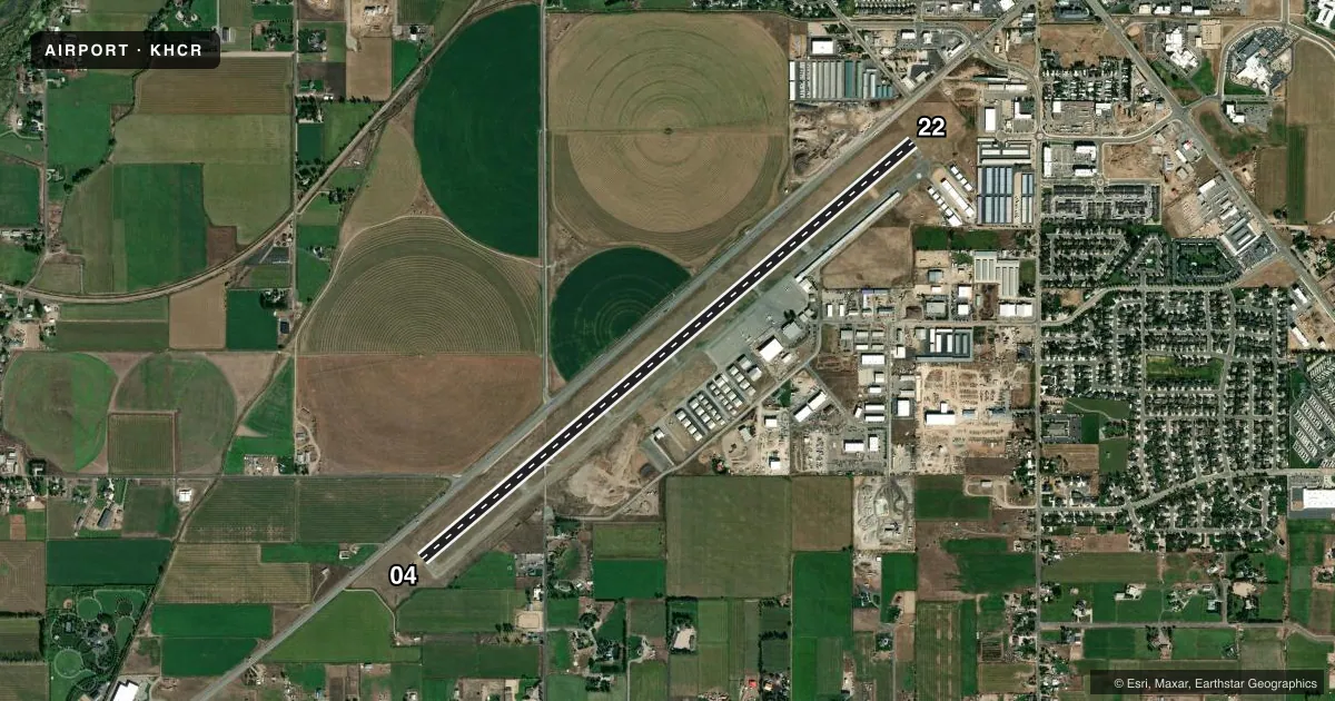
Runways & pattern
Full pagePattern entry · RWY 04
LEFT TRAFFICRunway end performance
| End | TORA | TODA | ASDA | LDA | VGSI | Approach lights | Obstruction |
|---|---|---|---|---|---|---|---|
| 22 | — | — | — | — | PAPI 4-box left(4°) | — | 12', road, 486' from thr, 395' R of cntrln, slope 23 |
Declared distances in feet. TORA = takeoff run available, TODA = takeoff distance, ASDA = accelerate-stop, LDA = landing distance.
Airport sketch
Runways drawn to scale from FAA survey coordinates, rendered over satellite imagery. Not for navigation.
Approaches & charts
Services on the field
Fuel grades, oxygen, maintenance, ramp storage and lighting — as declared to the FAA by the airport operator.
Fuel & services
- Fuel
- 100LLAJ
- Oxygen (bottled)
- Not available
- Oxygen (bulk)
- HIGH/LOW
- Airframe repair
- Major
- Power plant repair
- Major
- Other services
- GLD,INSTR,RNTL,SALES,TOW
Ramp & ground
- Transient storage
- Tie-down
- Hangar
- Landing fee
- Yes
- Customs
- Not available
- Lighting schedule
- SEE RMK
- Beacon schedule
- SS-SR
- Beacon
- White / Green (civil land)(WG)
- Wind indicator
- Lighted
- Segmented circle
- Yes
Fuel & FBOs
Cheapest 100LL and Jet A on the field and nearby. Always confirm with the FBO before taxi.
Airport notes
Surface conditions, obstructions, local procedures, lighting outages and other notes published with each FAA cycle.
General notes
- ACFT DEPARTING SOUTH-SOUTHWESTBOUND BE AWARE OF HIGH TFC VOLUME DESCENDING TO 16,000 FT OVER SPANE INTERSECTION.
- GLIDER ACTIVITY ON AND INVOF ARPT.
- BALLOON ACTIVITY ON AND INVOF ARPT.
- SNOW REMOVAL NOV-APR.
- FOR CD CTC SALT LAKE ARTCC AT 801-320-2568.
- PREFERRED CALM WIND RWY 22.
- COLD TEMPERATURE AIRPORT. ALTITUDE CORRECTION REQUIRED AT OR BELOW -16C.
- BIRDS ON & INVOF ARPT.
- EXPC FBO FEE'S IE: FAC CHRGS, TIE DOWN FEES ETC. FEES ARE SEPERATE IN ADDN TO ARPT LNDG FEES.
- SMALL ACFT PRKG LCTD SOUTH WEST OF FUEL FARM.
- RDO TMTN ON SFC MAY NOT BE RCVD AT OPPOSITE EOR. COMM INTFC FM TRRN INVOF APT, DEP ACFT MUST TMT START OF TAXI & DEPG RWY, PARL TWY HDG TO DEPG RWY, & LINE UP FOR DEP.
Lighting notes
- ACTVT PAPI RWY 22; MIRL RWY 4/22 - CTAF.
Approach & departure obstructions
- 22PAPI UNUSBL BYD 3.5 NM FM THLD AND BYD 6 DEGS LEFT AND RIGHT OF CNTRLN.
Other notes
- EXISTED PRIOR TO 1959.
- LNDG FEES: TSNT ACFT CTC AMGR.
VFR map & nearby airports
VFR sectional. Tap any ICAO chip to open that airport.
Key facts · KHCR
Answer card- ICAO
- KHCR
- Name
- HEBER VALLEY
- Location
- HEBER, UTAH
- Elevation
- 5,636.8 ft MSL
- Traffic pattern altitude
- 6,636.8 ft MSL (1,000 AGL)
- Control tower
- Non-towered (use CTAF)
- Total runways
- 1
- Longest runway
- 04/22 · 6,898 ft
- Published ILS approaches
- 0
- Published frequencies
- 2
- Magnetic variation
- 11°
- Current flight rules
- VFR
- Current wind
- 120° at 5 kt
- Favored runway now
- RWY 04
Heber Valley Airport (KHCR) sits in Heber, Utah at 5,636.8 ft MSL. It has one runway, 04/22, which is 6,898 ft long. The field is not towered. CTAF and UNICOM are both 122.8. No ILS approaches are published here.
Pattern altitude is not published. Use the standard 1,000 ft AGL for light piston operations unless the current Chart Supplement says otherwise. The airport is a cold temperature field. Altitude correction is required at or below minus 16 degrees Celsius. That matters here because the field elevation is already high.
OK3 Air is on the field. It carries AVGAS 100LL, Jet A and Jet A Prist. Published remarks also note birds, balloon activity and glider activity in the area. South-southwest departures should watch for traffic descending to 16,000 ft over the SPANE intersection. The calm wind runway is 22. Precision approach path indicator lighting for runway 22 and medium intensity runway lights for runways 4 and 22 are activated on CTAF. Small aircraft parking is southwest of the fuel farm. For clearance delivery, contact Salt Lake ARTCC at 801-320-2568. Check the current Chart Supplement for any landing fee details before arrival.