METAR & TAF UT9
UT9 does not publish a METAR.
Showing the nearest reporting station: KPVU (PROVO MUNI) · 16.9 NM away. Conditions at UT9 may differ.
METAR · KPVU
Observed 17:56Z
KPVU 261756Z 27004KT 10SM CLR 34/14 A3011 RMK AO2 SLP122 T03440144 10350 20206 58003
- Wind
- 270° @ 4 kt
- Visibility
- 10 SM
- Temp / Dew
- 34°C / 14°C
- Altimeter
- 30.11 inHg
- Clouds
- CLR
- Density alt
- 8,103 ft
- Ceiling
- Unlimited
- Rules
- VFR
Airport info & contacts
Manager on record, flight service, ARTCC, attendance schedule and pattern altitude — published by the FAA and refreshed every 28 days.
Location
- From city
- 1 NM S
- VFR sectional
- SALT LAKE CITY
- ARTCC
- ZLC · SALT LAKE CITY
- NOTAM facility
- CDC (NOTAM-D)
Airport manager
- Name
- MARK & ALINA PRINGLE
- Phone
- 801-766-0160
- Address
- 89 WEST AVIATORS WAY, FAIRFIELD UT 84013
Flight service · Hours
- FSS CDC
- CEDAR CITY1-800-WX-BRIEF
- Attendance
- 0900-1700
Frequencies
Tap any row to copy the frequency to your clipboard.
Runways & pattern
Full pagePattern entry · RWY 17
LEFT TRAFFICRunway end performance
| End | TORA | TODA | ASDA | LDA | VGSI | Approach lights | Obstruction |
|---|---|---|---|---|---|---|---|
| 17 | 5,200' | 5,200' | 5,200' | 5,000' | — | — | — |
| 35 | 5,200' | 5,200' | 5,000' | 5,000' | — | — | 14', hill, 201' from thr, 0' R of cntrln, slope 0 |
Declared distances in feet. TORA = takeoff run available, TODA = takeoff distance, ASDA = accelerate-stop, LDA = landing distance.
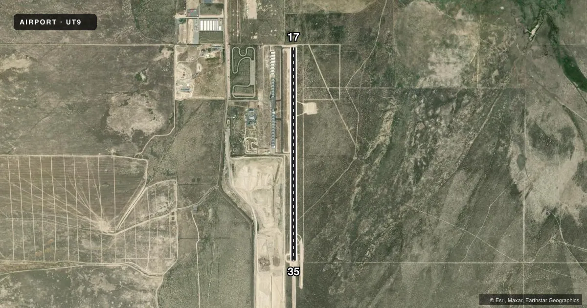
Airport sketch
Runways drawn to scale from FAA survey coordinates, rendered over satellite imagery. Not for navigation.
Approaches & charts
Services on the field
Fuel grades, oxygen, maintenance, ramp storage and lighting — as declared to the FAA by the airport operator.
Fuel & services
- Fuel
- MOGAS
- Oxygen (bottled)
- Low pressure
- Airframe repair
- Major
- Power plant repair
- Major
- Other services
- INSTR,SALES
Ramp & ground
- Transient storage
- Tie-down
- Hangar
- Landing fee
- Yes
- Wind indicator
- Yes
- Segmented circle
- No
Fuel & FBOs
Cheapest 100LL and Jet A on the field and nearby. Always confirm with the FBO before taxi.
Airport notes
Surface conditions, obstructions, local procedures, lighting outages and other notes published with each FAA cycle.
General notes
- TRNG ACT INVOF ARPT; MON CTAF.
- FOR CD CTC SALT LAKE CITY APCH AT 801-325-9670.
- FOR WX 4 CLICKS - CTAF.
- AVOID OVR FLT OF FIREWORK FAC WEST OF RWY.
- RWY 17 PREFERRED CALM WINDS
- BIRD ACT INVOF ARPT.
- RWY 17 STRAIGHT-IN LDGS PROHIBITED.
- AVOID LOW OVERFLIGHT OF RESIDENTIAL AREAS.
- LNDG FEES IN EFFECT FOR ALL ACFT.
- LIMIT TGLS.
- USE CTN RDCD TWY & TXL WID.
Approach & departure obstructions
- 3514 FT HILL, 50 FT DSTC, 0 FT B.
Other notes
- MANAGER801-580-5688 CELL.
VFR map & nearby airports
VFR sectional. Tap any ICAO chip to open that airport.
Key facts · UT9
Answer card- ICAO
- UT9
- Name
- WEST DESERT AIRPARK
- Location
- FAIRFIELD, UTAH
- Elevation
- 4,886 ft MSL
- Traffic pattern altitude
- 5,886 ft MSL (1,000 AGL)
- Control tower
- Non-towered (use CTAF)
- Total runways
- 1
- Longest runway
- 17/35 · 5,200 ft
- Published ILS approaches
- 0
- Published frequencies
- 2
- Magnetic variation
- 11°
- Current flight rules
- VFR
- Current wind
- 270° at 4 kt
- Favored runway now
- RWY 17
West Desert Airpark (UT9) sits near Fairfield, Utah. The field elevation is 4,886 ft MSL. It has one runway. Runway 17/35 is 5,200 ft long and asphalt. There is no control tower. CTAF and UNICOM are both 123.0. No ILS approaches are published here.
Pattern altitude is not published. Use the standard 1,000 ft AGL pattern for light piston aircraft unless the current Chart Supplement says otherwise. That puts the pattern at 5,886 ft MSL. Check the current Chart Supplement for any published noise or curfew restrictions before flying into the field. Published remarks also say touch-and-go landings are limited. Landing fees are in effect for all aircraft.
The airport sits in a high-elevation area. Expect performance to reflect the altitude. The published remarks also call out bird activity, training traffic, reduced taxiway and taxilane width and a firework facility west of the runway. Runway 17 straight-in landings are prohibited. Runway 17 is preferred for calm winds. There are no on-field FBOs listed. Contact the airport operator directly before arrival. Call the field on CTAF or UNICOM for current FBO availability. The manager can also be reached at 801-580-5688.