METAR & TAF KBTF
KBTF does not publish a METAR.
Showing the nearest reporting station: KSLC (SALT LAKE CITY INTL) · 5.3 NM away. Conditions at KBTF may differ.
METAR · KSLC
Observed 06:54Z
KSLC 270654Z 18007KT 10SM BKN140 OVC170 33/11 A2998 RMK AO2 SLP076 T03330111 404000256 $
- Wind
- 180° @ 7 kt
- Visibility
- 10 SM
- Temp / Dew
- 33°C / 11°C
- Altimeter
- 29.98 inHg
- Clouds
- OVC
- Density alt
- 7,340 ft
- Ceiling
- 14,000 ft AGL
- Rules
- VFR
Airport info & contacts
Manager on record, flight service, ARTCC, attendance schedule and pattern altitude — published by the FAA and refreshed every 28 days.
Location
- From city
- 3 NM SW
- VFR sectional
- SALT LAKE CITY
- ARTCC
- ZLC · SALT LAKE CITY
- NOTAM facility
- CDC (NOTAM-D)
Airport manager
- Name
- CHRIS VOLZER
- Phone
- 801-295-3877
- Address
- 1887 S. 1800 W., #2, WOODS CROSS UT 84087
Flight service · Hours
- FSS CDC
- CEDAR CITY1-800-WX-BRIEF
- Attendance
- MON-FRI · 0700-1900
- SAT-SUN · 0800-1700
Frequencies
Tap any row to copy the frequency to your clipboard.
Runways & pattern
Full pagePattern entry · RWY 17
LEFT TRAFFICRunway end performance
| End | TORA | TODA | ASDA | LDA | VGSI | Approach lights | Obstruction |
|---|---|---|---|---|---|---|---|
| 17 | — | — | — | — | PAPI 2-box left(3.5°) | — | 8', fence, 232' from thr, 0' R of cntrln, slope 4 |
| 35 | — | — | — | — | PAPI 2-box left(3.5°) | — | 6', fence, 200' from thr, 90' R of cntrln, slope 0 |
Declared distances in feet. TORA = takeoff run available, TODA = takeoff distance, ASDA = accelerate-stop, LDA = landing distance.
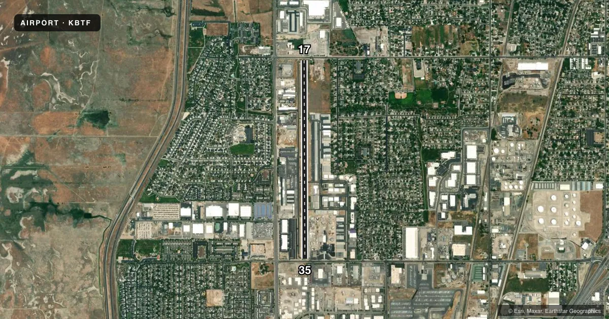
Airport sketch
Runways drawn to scale from FAA survey coordinates, rendered over satellite imagery. Not for navigation.
Approaches & charts
Services on the field
Fuel grades, oxygen, maintenance, ramp storage and lighting — as declared to the FAA by the airport operator.
Fuel & services
- Fuel
- 100LLAMOGAS
- Oxygen (bottled)
- Not available
- Oxygen (bulk)
- Not available
- Airframe repair
- Major
- Power plant repair
- Major
- Other services
- AVNCS,INSTR,RNTL
Ramp & ground
- Transient storage
- Tie-down
- Hangar
- Landing fee
- Yes
- Customs
- Not available
- Lighting schedule
- SEE RMK
- Beacon schedule
- SS-SR
- Beacon
- White / Green (civil land)(WG)
- Wind indicator
- Lighted
- Segmented circle
- No
Fuel & FBOs
Cheapest 100LL and Jet A on the field and nearby. Always confirm with the FBO before taxi.
Airport notes
Surface conditions, obstructions, local procedures, lighting outages and other notes published with each FAA cycle.
General notes
- FOR CD CTC SALT LAKE CITY APCH AT 801-325-9670.
Lighting notes
- ACTVT LIRL RWY 17/35 - CTAF.
Fuel notes
- 100LL100LL & JET A SELF SVC FUEL AVBL 24 HRS WITH CC.
Runway surface & condition
- 17/35ALL DEPS WILL BE TO THE EAST.
Approach & departure obstructions
- 178 FT BLDG, 0 FT DSTC, 122 FT LEFT.
- 356 FT FENCE, 0-200 FT DSTC, 94 FT RIGHT.
- 17APCH SLP 11:1 TO DTHR OVR 8 FT BLDG, 90 FT DSTC, 128 FT LEFT.
- 35CTLG OBSTN EXCEEDS A 45 DEG SLP.
Other notes
- FOR LNDG FEES, CTC AMGR.
- STD HELI TPA 1000 FT AGL. HELI TPA AMDD TO AGREE WITH ALL ACFT AT 1000 FT AGL.
VFR map & nearby airports
VFR sectional. Tap any ICAO chip to open that airport.
Key facts · KBTF
Answer card- ICAO
- KBTF
- Name
- SKYPARK
- Location
- BOUNTIFUL, UTAH
- Elevation
- 4,237.1 ft MSL
- Traffic pattern altitude
- 5,237.1 ft MSL (1,000 AGL)
- Control tower
- Non-towered (use CTAF)
- Total runways
- 1
- Longest runway
- 17/35 · 4,634 ft
- Published ILS approaches
- 0
- Published frequencies
- 3
- Magnetic variation
- 15°
- Current flight rules
- VFR
- Current wind
- 180° at 7 kt
- Favored runway now
- RWY 17
Skypark Airport (KBTF) sits in Bountiful, Utah. The field elevation is 4,237.1 ft MSL. It has one runway, 17/35, which is 4,634 ft long and paved with asphalt. There is no control tower. CTAF and UNICOM are both 122.8. CD/P is 120.7.
No ILS approaches are published here. The pattern altitude is not published in the facts, so use the standard 1,000 ft AGL pattern unless the current Chart Supplement says otherwise. The published helicopter pattern altitude is also 1,000 ft AGL. For clearance delivery, Salt Lake City Approach handles it at 801-325-9670.
Skypark Airport is a busy local field with useful self-serve fuel access. The on-field FBO is Skypark Airport. It carries 100LL, Jet A, Jet A Prist and MOGAS. 100LL and Jet A self-service fuel are available 24 hours with a credit card. The remarks also note that all departures will be to the east. That matters for planning your takeoff and runway use.
Watch the published obstructions near both runway ends. There is a fence near runway 35. There are also buildings near runway 17, including one close to the threshold. A cataloged obstruction also exceeds a 45 degree slope. The airport sits at high elevation, so expect performance planning to matter on warm days. Check the current Chart Supplement for any additional local procedures before you go.