METAR & TAF 2UT
2UT does not publish a METAR.
Showing the nearest reporting station: KOGD (OGDEN-HINCKLEY) · 14.7 NM away. Conditions at 2UT may differ.
METAR · KOGD
Observed 12:53Z
KOGD 271253Z 16006KT 10SM CLR 29/08 A3002 RMK AO2 SLP084 T02940078 $
- Wind
- 160° @ 6 kt
- Visibility
- 10 SM
- Temp / Dew
- 29°C / 8°C
- Altimeter
- 30.02 inHg
- Clouds
- CLR
- Density alt
- 7,327 ft
- Ceiling
- Unlimited
- Rules
- VFR
Airport info & contacts
Manager on record, flight service, ARTCC, attendance schedule and pattern altitude — published by the FAA and refreshed every 28 days.
Location
- From city
- 9 NM W
- VFR sectional
- SALT LAKE CITY
- ARTCC
- ZLC · SALT LAKE CITY
- NOTAM facility
- CDC
Airport manager
- Name
- ROY EVANS II
- Phone
- 385-220-5313
- Address
- 1887 S REDWOOD ROAD, UNIT 16, WOODS CROSS UT 84087
Flight service · Hours
- FSS CDC
- CEDAR CITY1-800-WX-BRIEF
Frequencies
Tap any row to copy the frequency to your clipboard.
Runways & pattern
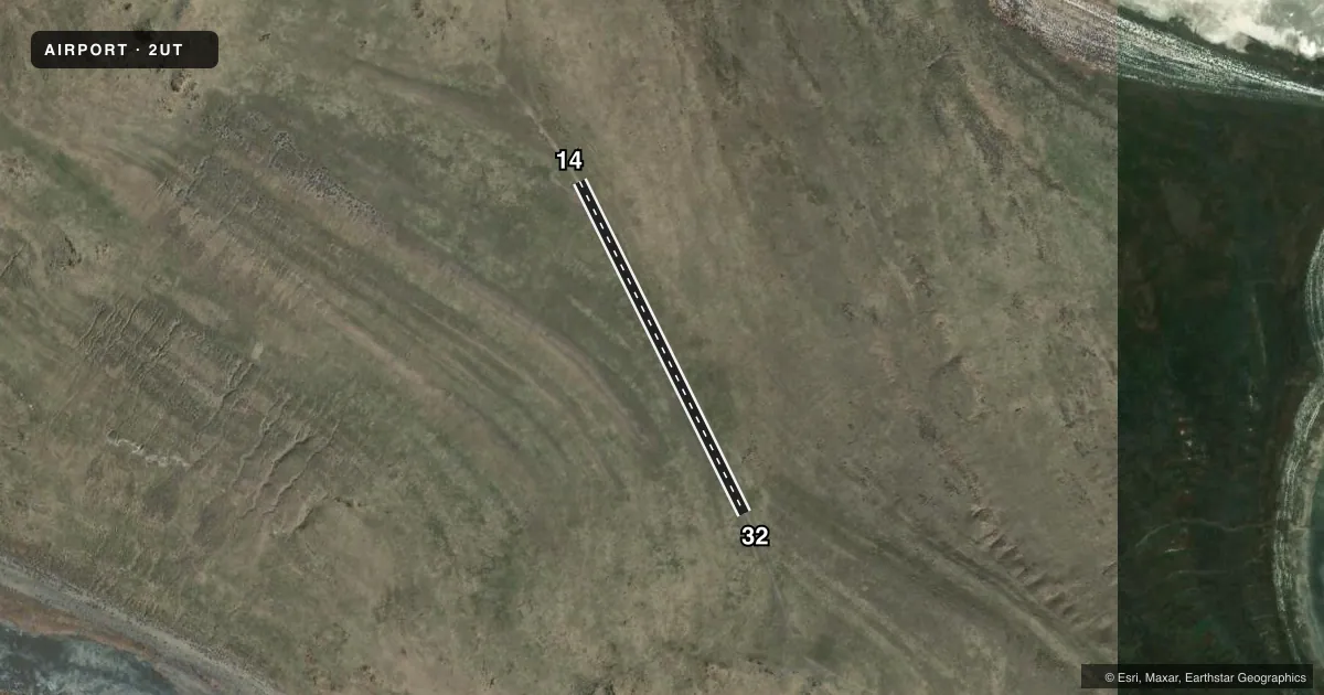
Full pagePattern entry · RWY 14
RIGHT TRAFFICAirport sketch
Runways drawn to scale from FAA survey coordinates, rendered over satellite imagery. Not for navigation.
Approaches & charts
Services on the field
Fuel grades, oxygen, maintenance, ramp storage and lighting — as declared to the FAA by the airport operator.
Fuel & services
- Fuel
- Not available
Ramp & ground
- Transient storage
- Not published
Fuel & FBOs
Cheapest 100LL and Jet A on the field and nearby. Always confirm with the FBO before taxi.
Airport notes
Surface conditions, obstructions, local procedures, lighting outages and other notes published with each FAA cycle.
General notes
- UPPER AND LOWER FREMONT ISLAND ARPTS REQD TO USE CTAF FREQ - 122.9.
Other notes
- MANAGEREMAIL: MMAASS@UTAH.GOV.
- OWNERATTN: MARISA WEINBERG. EMAIL: MWEINBERG@UTAH.GOV.
- 14/32DIRT-GRVL
VFR map & nearby airports
VFR sectional. Tap any ICAO chip to open that airport.
Key facts · 2UT
Answer card- ICAO
- 2UT
- Name
- FREMONT ISLAND UPPER
- Location
- HOOPER, UTAH
- Elevation
- 4,654 ft MSL
- Traffic pattern altitude
- 5,654 ft MSL (1,000 AGL)
- Control tower
- Non-towered (use CTAF)
- Total runways
- 1
- Longest runway
- 14/32 · 1,980 ft
- Published ILS approaches
- 0
- Published frequencies
- 0
- Magnetic variation
- 11°
- Current flight rules
- VFR
- Current wind
- 160° at 6 kt
- Favored runway now
- RWY 14
Fremont Island Upper (2UT) sits in Hooper, Utah on Fremont Island. The field elevation is 4,654 ft MSL. It has one runway. Runway 14/32 is 1,980 ft long and the published surface is dirt and gravel. This is a non-towered field. No ILS approaches are published here.
The pattern altitude is not published. Use the standard 1,000 ft AGL pattern unless the current FAA Chart Supplement or the airport operator gives you different guidance. For this field that works out to about 5,654 ft MSL. The published remarks also say Upper and Lower Fremont Island airports are required to use CTAF 122.9. That matters because there are no listed on-field frequencies in the facts block.
There are no on-field FBOs listed. Plan on coordinating directly with the airport operator before you go. The published remarks list Marisa Weinberg at mweinberg@utah.gov. They also list the manager at mmaass@utah.gov. With a dirt strip at this elevation, a pilot should think about surface condition, takeoff roll and density altitude before committing. Check the current FAA Chart Supplement for any additional operating notes before flying in.