METAR & TAF KSVR
Current METAR
Observed 14:55Z
KSVR 271455Z AUTO 17013KT 10SM CLR 30/12 A3008 RMK AO2
- Wind
- 170° @ 13 kt
- Visibility
- 10 SM
- Temp / Dew
- 30°C / 12°C
- Altimeter
- 30.08 inHg
- Clouds
- CLR
- Density alt
- 7,314 ft
- Ceiling
- Unlimited
- Rules
- VFR
Airport info & contacts
Manager on record, flight service, ARTCC, attendance schedule and pattern altitude — published by the FAA and refreshed every 28 days.
Location
- From city
- 7 NM SW
- VFR sectional
- SALT LAKE CITY
- ARTCC
- ZLC · SALT LAKE CITY
- NOTAM facility
- CDC (NOTAM-D)
Airport manager
- Name
- KEVIN THORNOCK
- Phone
- 801-531-4777
- Address
- PO BOX 145550, SALT LAKE CITY UT 84114
Flight service · Hours
- FSS CDC
- CEDAR CITY1-800-WX-BRIEF
- Attendance
- MON-FRI · 0800-1800
- SAT-SUN · 0700-1700
Frequencies
Tap any row to copy the frequency to your clipboard.
Runways & pattern
Full pagePattern entry · RWY 16
RIGHT TRAFFICRunway end performance
| End | TORA | TODA | ASDA | LDA | VGSI | Approach lights | Obstruction |
|---|---|---|---|---|---|---|---|
| 16 | — | — | — | — | PAPI 4-box left(3°) | — | — |
| 34 | — | — | — | — | PAPI 4-box left(3°) | — | — |
Declared distances in feet. TORA = takeoff run available, TODA = takeoff distance, ASDA = accelerate-stop, LDA = landing distance.
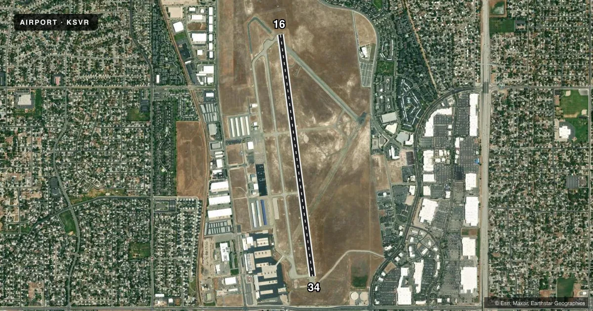
Airport sketch
Runways drawn to scale from FAA survey coordinates, rendered over satellite imagery. Not for navigation.
Approaches & charts
Services on the field
Fuel grades, oxygen, maintenance, ramp storage and lighting — as declared to the FAA by the airport operator.
Fuel & services
- Fuel
- 100LLA
- Oxygen (bottled)
- Low pressure
- Oxygen (bulk)
- High pressure
- Airframe repair
- Major
- Power plant repair
- Major
- Other services
- AVNCS,CHTR,INSTR,RNTL,SURV
Ramp & ground
- Transient storage
- Tie-down
- Hangar
- Landing fee
- No fee published
- Customs
- Not available
- Lighting schedule
- SEE RMK
- Beacon schedule
- SS-SR
- Beacon
- White / Green (civil land)(WG)
- Wind indicator
- Lighted
- Segmented circle
- Yes
Fuel & FBOs
Cheapest 100LL and Jet A on the field and nearby. Always confirm with the FBO before taxi.
Airport notes
Surface conditions, obstructions, local procedures, lighting outages and other notes published with each FAA cycle.
General notes
- BIRDS ON & INVOF ARPT.
- ARNG OPS - 49.625/255.7.
- CTC ARMY OPS - D766-3483.
- FOR CD CTC SALT LAKE CITY APCH AT 801-325-9670.
- FLT TRNG INVOF ARPT.
Lighting notes
- ACTVT REIL RWY 16 & 34; MIRL RWY 16/34 - CTAF.
VFR map & nearby airports
VFR sectional. Tap any ICAO chip to open that airport.
Key facts · KSVR
Answer card- ICAO
- KSVR
- Name
- SOUTH VALLEY RGNL
- Location
- SALT LAKE CITY, UTAH
- Elevation
- 4,606.4 ft MSL
- Traffic pattern altitude
- 5,606.4 ft MSL (1,000 AGL)
- Control tower
- Non-towered (use CTAF)
- Total runways
- 1
- Longest runway
- 16/34 · 5,862 ft
- Published ILS approaches
- 0
- Published frequencies
- 5
- Magnetic variation
- 14°
- Current flight rules
- VFR
- Current wind
- 170° at 13 kt
- Favored runway now
- RWY 16
South Valley Rgnl Airport sits in Salt Lake City, Utah. Field elevation is 4,606.4 ft MSL. The airport has one runway. Runway 16/34 is 5,862 ft long with an asphalt surface. There is no control tower. Clearance delivery is handled through Salt Lake City Approach. The published approach frequencies are 120.9 and 322.3. CTAF is 122.7. UNICOM is 122.7.
No ILS approaches are published here. Pattern altitude is not published, so use the standard 1,000 ft AGL for light piston traffic unless the current Chart Supplement says otherwise. That puts the pattern at about 5,606.4 ft MSL based on the listed field elevation. SkyShare is on the field. It carries 100LL and Jet A. Call ahead at (801) 561-0420 for current service status.
This is a higher-elevation airport in the Salt Lake City area. Expect density altitude to matter on warm days. Birds are reported on and near the airport. Flight training also takes place in the vicinity. Runway end identifier lights are active on 16 and 34. Medium intensity runway lights are on 16 and 34 and are controlled by CTAF. Check the current Chart Supplement for any noise or operational notes before you go.