METAR & TAF KTVY
Current METAR
Observed 14:55Z
KTVY 271455Z AUTO 19016KT 5SM HZ CLR 33/09 A3002 RMK AO2
- Wind
- 190° @ 16 kt
- Visibility
- 5 SM
- Temp / Dew
- 33°C / 9°C
- Altimeter
- 30.02 inHg
- Clouds
- CLR
- Density alt
- 7,394 ft
- Ceiling
- Unlimited
- Rules
- MVFR
Airport info & contacts
Manager on record, flight service, ARTCC, attendance schedule and pattern altitude — published by the FAA and refreshed every 28 days.
Location
- From city
- 5 NM NW
- VFR sectional
- SALT LAKE CITY
- ARTCC
- ZLC · SALT LAKE CITY
- NOTAM facility
- CDC (NOTAM-D)
Airport manager
- Name
- KEVIN THORNOCK
- Phone
- 801-531-4777
- Address
- PO BOX 145550, SALT LAKE CITY UT 84114-5550
Flight service · Hours
- FSS CDC
- CEDAR CITY1-800-WX-BRIEF
- Attendance
- UNATTENDED
Frequencies
Tap any row to copy the frequency to your clipboard.
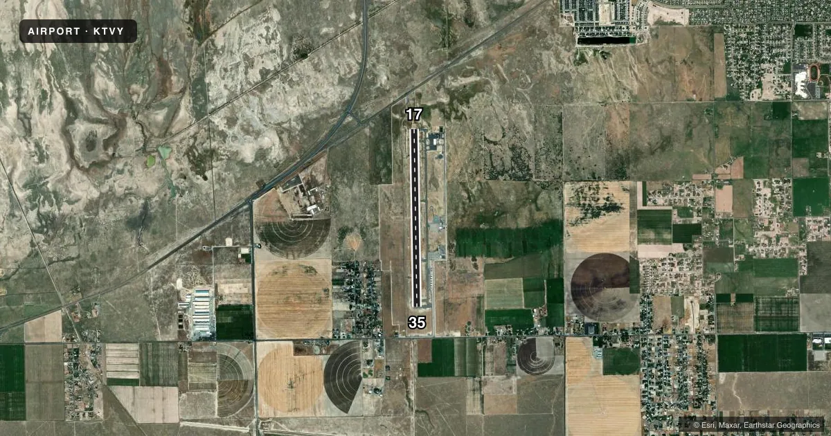
Runways & pattern
Full pagePattern entry · RWY 17
LEFT TRAFFICRunway end performance
| End | TORA | TODA | ASDA | LDA | VGSI | Approach lights | Obstruction |
|---|---|---|---|---|---|---|---|
| 17 | 6,102' | 6,102' | 6,102' | 6,102' | PAPI 4-box right(3°) | MALSR | — |
| 35 | 6,102' | 6,102' | 6,102' | 5,980' | PAPI 4-box left(3°) | — | 22', road, 1059' from thr, slope 39 |
Declared distances in feet. TORA = takeoff run available, TODA = takeoff distance, ASDA = accelerate-stop, LDA = landing distance.
Airport sketch
Runways drawn to scale from FAA survey coordinates, rendered over satellite imagery. Not for navigation.
Approaches & charts
ILS · 1
Services on the field
Fuel grades, oxygen, maintenance, ramp storage and lighting — as declared to the FAA by the airport operator.
Fuel & services
- Fuel
- 100LL
- Oxygen (bottled)
- Not available
- Oxygen (bulk)
- Not available
- Airframe repair
- Not available
- Power plant repair
- Not available
- Other services
- PAJA
Ramp & ground
- Transient storage
- Tie-down
- Landing fee
- No fee published
- Customs
- Not available
- Lighting schedule
- SEE RMK
- Beacon schedule
- SS-SR
- Beacon
- White / Green (civil land)(WG)
- Wind indicator
- Lighted
- Segmented circle
- Yes
Fuel & FBOs
Cheapest 100LL and Jet A on the field and nearby. Always confirm with the FBO before taxi.
Airport notes
Surface conditions, obstructions, local procedures, lighting outages and other notes published with each FAA cycle.
General notes
- EXTSV FLT TRNG INVOF ARPT.
- FOR CD CTC SALT LAKE CITY APCH AT 801-325-9670/9671/9672.
- BIRDS ON & INVOF ARPT.
- BLM AIR TANKER OPS ON & INVOF ARPT FROM MAY TO OCT.
Lighting notes
- ACTVT MALSR RWY 17; REIL RWY 35; PAPI RWY 17 & 35 - CTAF.
Other notes
- PAJASKYDIVING ACT APR TO NOV.
VFR map & nearby airports
VFR sectional. Tap any ICAO chip to open that airport.
Key facts · KTVY
Answer card- ICAO
- KTVY
- Name
- BOLINDER FLD/TOOELE VALLEY
- Location
- TOOELE, UTAH
- Elevation
- 4,321.1 ft MSL
- Traffic pattern altitude
- 5,321.1 ft MSL (1,000 AGL)
- Control tower
- Non-towered (use CTAF)
- Total runways
- 1
- Longest runway
- 17/35 · 6,102 ft
- Published ILS approaches
- 1
- Published frequencies
- 7
- Magnetic variation
- 13°
- Current flight rules
- MVFR
- Current wind
- 190° at 16 kt
- Favored runway now
- RWY 17
Bolinder Fld/Tooele Valley sits in Tooele, Utah at 4,321.1 ft MSL. It has one runway. Runway 17/35 is 6,102 ft long with asphalt pavement. The field is not towered. CTAF and UNICOM are both 123.0. Clearance delivery and approach services come from Salt Lake City Approach. Check the current Chart Supplement for the latest procedures before departure.
The airport has one ILS approach to runway 17. MALSR lighting is active on runway 17. REIL lighting is on runway 35. PAPI is available on both runway ends and is controlled by CTAF. The published pattern altitude is not listed. Use 1,000 ft AGL for light piston operations unless the current Chart Supplement says otherwise. That puts the standard pattern at 5,321.1 ft MSL.
Tooele Valley Airport is the on-field FBO. It carries 100LL. Call the FBO directly at (801) 575-2401 for current service details. This field sees a lot of training traffic. Skydiving runs from April through November. BLM air tanker activity also occurs here from May through October. Birds are present in the area. Expect a busy pattern and keep a sharp scan on arrival and departure.