METAR & TAF 1UT
1UT does not publish a METAR.
Showing the nearest reporting station: KOGD (OGDEN-HINCKLEY) · 16.7 NM away. Conditions at 1UT may differ.
METAR · KOGD
Observed 12:53Z
KOGD 271253Z 16006KT 10SM CLR 29/08 A3002 RMK AO2 SLP084 T02940078 $
- Wind
- 160° @ 6 kt
- Visibility
- 10 SM
- Temp / Dew
- 29°C / 8°C
- Altimeter
- 30.02 inHg
- Clouds
- CLR
- Density alt
- 6,806 ft
- Ceiling
- Unlimited
- Rules
- VFR
Airport info & contacts
Manager on record, flight service, ARTCC, attendance schedule and pattern altitude — published by the FAA and refreshed every 28 days.
Location
- From city
- 10 NM W
- VFR sectional
- SALT LAKE CITY
- ARTCC
- ZLC · SALT LAKE CITY
- NOTAM facility
- CDC
Airport manager
- Name
- ROY EVANS II
- Phone
- 385-220-5313
- Address
- 1887 S REDWOOD ROAD, UNIT 16, WOODS CROSS UT 84087
Flight service · Hours
- FSS CDC
- CEDAR CITY1-800-WX-BRIEF
Frequencies
Tap any row to copy the frequency to your clipboard.
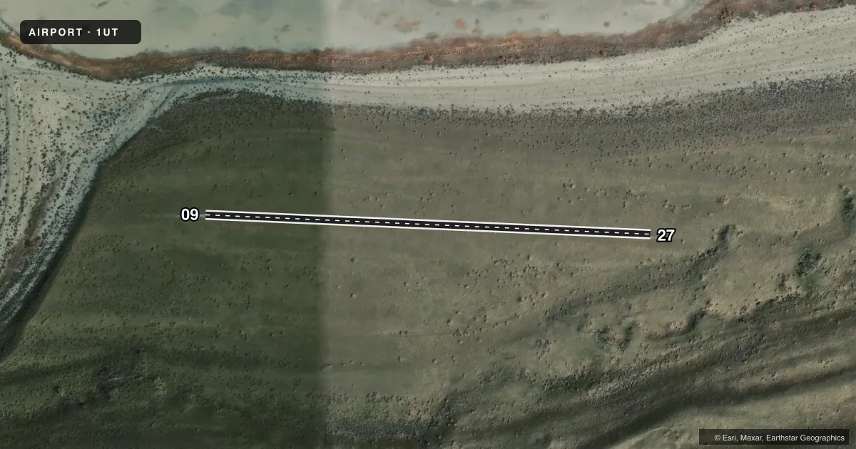
Runways & pattern
Full pagePattern entry · RWY 09
LEFT TRAFFICAirport sketch
Runways drawn to scale from FAA survey coordinates, rendered over satellite imagery. Not for navigation.
Approaches & charts
Services on the field
Fuel grades, oxygen, maintenance, ramp storage and lighting — as declared to the FAA by the airport operator.
Fuel & services
- Fuel
- Not available
Ramp & ground
- Transient storage
- Not published
Fuel & FBOs
Cheapest 100LL and Jet A on the field and nearby. Always confirm with the FBO before taxi.
Airport notes
Surface conditions, obstructions, local procedures, lighting outages and other notes published with each FAA cycle.
General notes
- UPPER AND LOWER FREMONT ISLAND ARPTS REQD TO USE CTAF FREQ -122.9.
Other notes
- MANAGEREMAIL: MMAASS@UTAH.GOV.
- OWNERATTN: MARISA WEINBERG. EMAIL: MWEINBERG@UTAH.GOV.
- 09/27DIRT-GRVL
VFR map & nearby airports
VFR sectional. Tap any ICAO chip to open that airport.
Key facts · 1UT
Answer card- ICAO
- 1UT
- Name
- FREMONT ISLAND LOWER
- Location
- HOOPER, UTAH
- Elevation
- 4,234 ft MSL
- Traffic pattern altitude
- 5,234 ft MSL (1,000 AGL)
- Control tower
- Non-towered (use CTAF)
- Total runways
- 1
- Longest runway
- 09/27 · 1,843 ft
- Published ILS approaches
- 0
- Published frequencies
- 0
- Magnetic variation
- 11°
- Current flight rules
- VFR
- Current wind
- 160° at 6 kt
- Favored runway now
- RWY 09
Fremont Island Lower (1UT) sits at Hooper, Utah. Field elevation is 4,234 ft MSL. The airport has one runway. Runway 09/27 is 1,843 ft long and the published surface is dirt and gravel. No tower is published here. No ILS approaches are published either. The required CTAF frequency for Upper and Lower Fremont Island airports is 122.9.
Pattern altitude is not published. Use the standard 1,000 ft AGL pattern unless the current Chart Supplement or the airport operator gives you something different. At this elevation, performance will be a factor. Plan for the density altitude you expect on the day of flight. The runway is short. That makes takeoff and landing distance planning important. There are no on-field FBOs listed in the facts. Contact the airport operator directly before arrival if you need current field status or support. Published remarks also note the runway surface is dirt and gravel. The airport contact listed in the remarks is Marisa Weinberg at mweinberg@utah.gov. The manager contact is mmaass@utah.gov. Check the current FAA Chart Supplement for any other operational notes before you go.