METAR & TAF 42U
42U does not publish a METAR.
Showing the nearest reporting station: KOGD (OGDEN-HINCKLEY) · 11.4 NM away. Conditions at 42U may differ.
METAR · KOGD
Observed 03:53Z
KOGD 270353Z AUTO 17007KT 10SM CLR 33/08 A2996 RMK AO2 SLP066 T03280078 $
- Wind
- 170° @ 7 kt
- Visibility
- 10 SM
- Temp / Dew
- 33°C / 8°C
- Altimeter
- 29.96 inHg
- Clouds
- CLR
- Density alt
- 8,335 ft
- Ceiling
- Unlimited
- Rules
- VFR
Airport info & contacts
Manager on record, flight service, ARTCC, attendance schedule and pattern altitude — published by the FAA and refreshed every 28 days.
Location
- From city
- 8 NM NW
- VFR sectional
- SALT LAKE CITY
- Pattern altitude
- 980 ft AGL · 6,000 ft MSL
- ARTCC
- ZLC · SALT LAKE CITY
- NOTAM facility
- CDC (NOTAM-D)
Airport manager
- Name
- JOE GARFIELD
- Phone
- 801-821-6619
- Address
- 5876 N COTTONWOOD CANYON RD, 3806 W WILLOWCREEK ROAD, MT. GREEN UT 84050
Flight service · Hours
- FSS CDC
- CEDAR CITY1-800-WX-BRIEF
- Attendance
- Unattended
Frequencies
Tap any row to copy the frequency to your clipboard.
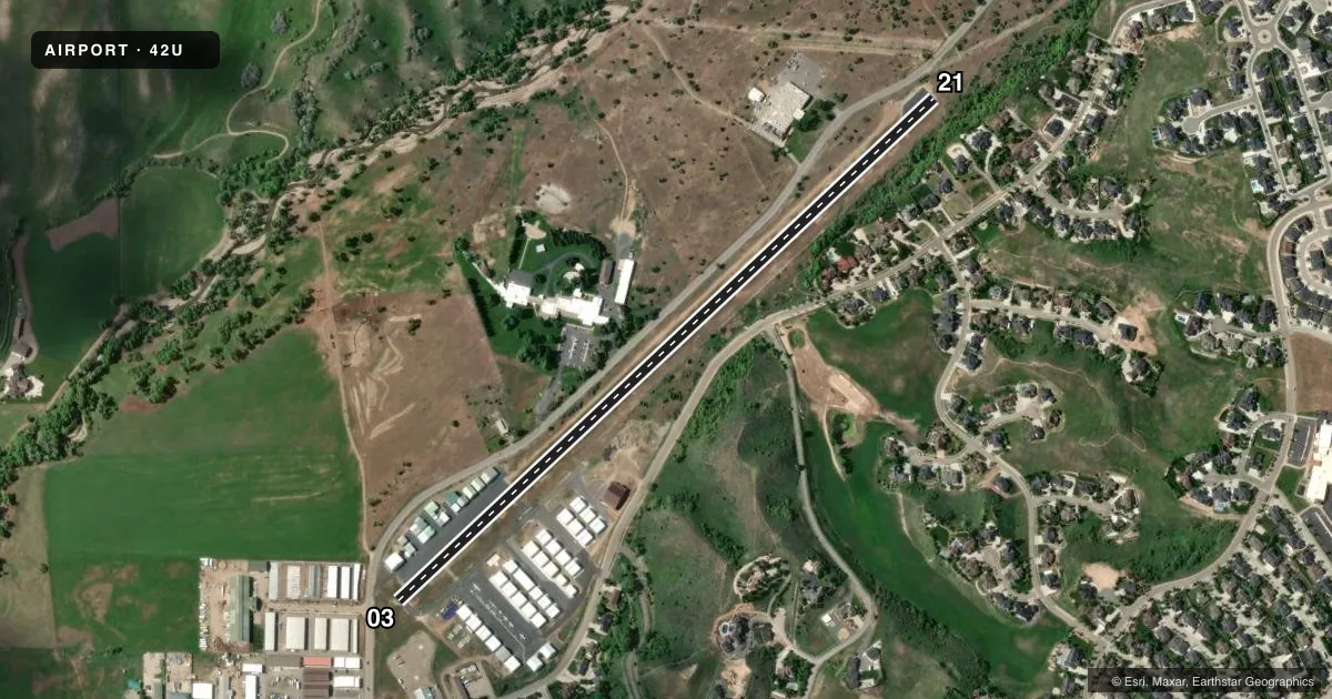
Runways & pattern
Full pagePattern entry · RWY 21
LEFT TRAFFICRunway end performance
| End | TORA | TODA | ASDA | LDA | VGSI | Approach lights | Obstruction |
|---|---|---|---|---|---|---|---|
| 03 | — | — | — | — | — | — | 15', road, 209' from thr, slope 0 |
| 21 | — | — | — | — | — | — | 40', trees, 225' from thr, 75' R of cntrln, slope 0 |
Declared distances in feet. TORA = takeoff run available, TODA = takeoff distance, ASDA = accelerate-stop, LDA = landing distance.
Airport sketch
Runways drawn to scale from FAA survey coordinates, rendered over satellite imagery. Not for navigation.
Approaches & charts
Services on the field
Fuel grades, oxygen, maintenance, ramp storage and lighting — as declared to the FAA by the airport operator.
Fuel & services
- Fuel
- Not available
- Oxygen (bottled)
- Not available
- Oxygen (bulk)
- Not available
- Airframe repair
- Not available
- Power plant repair
- Not available
- Other services
- GLD,TOW
Ramp & ground
- Transient storage
- Tie-down
- Landing fee
- No fee published
- Wind indicator
- Yes
- Segmented circle
- No
Fuel & FBOs
Cheapest 100LL and Jet A on the field and nearby. Always confirm with the FBO before taxi.
Airport notes
Surface conditions, obstructions, local procedures, lighting outages and other notes published with each FAA cycle.
General notes
- TREES, FENCES, AND HANGARS 125 FT FM CNTRLN BOTH SIDES RWY 03/21.
- DEER AND MOOSE INVOF ARPT.
- ITNRNT TFC USE EAST APN TIE DOWNS.
- FOR CD CTC SALT LAKE CITY APCH AT 801-325-9670.
Approach & departure obstructions
- 035 FT FENCE 57-199 FT DSTC 89 FT L.
- 21ELECTRICAL BOX - 163 FT DSTC, 93 FT R.
- 03APCH SLOPE 0:1 TO DSPLCD THLD OVR 12 FT HGR 0 FT DSTC, 123 FT L.
- 21APCH SLOPE 11:1 TO DSPLCD THLD.
Other notes
- EXISTED PRIOR TO 1959.
- PILOTS NEED TO SUPPLY THEIR OWN ROPES/CHAINS FOR TIE DOWNS.
- PILOT PRVDS OWN ROPES.
- OWNERCOUNTY CLERK
- GLDEXTSV GLD & ULTRALIGHT ACT ON AND INVOF ARPT
VFR map & nearby airports
VFR sectional. Tap any ICAO chip to open that airport.
Key facts · 42U
Answer card- ICAO
- 42U
- Name
- MORGAN COUNTY
- Location
- MORGAN, UTAH
- Elevation
- 5,020 ft MSL
- Traffic pattern altitude
- 6,000 ft MSL (980 AGL)
- Control tower
- Non-towered (use CTAF)
- Total runways
- 1
- Longest runway
- 03/21 · 3,904 ft
- Published ILS approaches
- 0
- Published frequencies
- 2
- Magnetic variation
- 15°
- Current flight rules
- VFR
- Current wind
- 170° at 7 kt
- Favored runway now
- RWY 21
Morgan County Airport (42U) is in Morgan, Utah. The field elevation is 5,020 ft MSL. It has one runway, 03/21, which is 3,904 ft long and paved with asphalt. The airport is uncontrolled. CTAF and UNICOM are both 122.8. No ILS approaches are published here.
The pattern altitude is 980 ft AGL, which is 6,000 ft MSL. That matters here because the airport sits high enough that performance planning deserves attention, especially on warm days. Published remarks also call out wildlife in the area. Deer and moose are reported near the airport. There are obstructions near both runway ends. The runway environment also has trees, fences and hangars close to the centerline on both sides.
There are no on-field FBOs listed in the facts. Itinerant traffic uses the east apron tie downs. Pilots need to bring their own ropes and chains. For clearance delivery, contact Salt Lake City Approach at 801-325-9670. If you need current operational details, check the current FAA Chart Supplement or call the airport operator directly before departure.