METAR & TAF KEVW
Current METAR
Observed 11:53Z
KEVW 271153Z AUTO 18004KT 10SM BKN110 23/06 A3028 RMK AO2 SLP120 T02330056 10267 20206 52003 $
- Wind
- 180° @ 4 kt
- Visibility
- 10 SM
- Temp / Dew
- 23°C / 6°C
- Altimeter
- 30.28 inHg
- Clouds
- BKN
- Density alt
- 9,371 ft
- Ceiling
- 11,000 ft AGL
- Rules
- VFR
Airport info & contacts
Manager on record, flight service, ARTCC, attendance schedule and pattern altitude — published by the FAA and refreshed every 28 days.
Location
- From city
- 3 NM W
- VFR sectional
- SALT LAKE CITY
- ARTCC
- ZLC · SALT LAKE CITY
- NOTAM facility
- EVW (NOTAM-D)
Airport manager
- Name
- MIKE LASALLE
- Phone
- 307-789-2256
- Address
- PO BOX 756, EVANSTON WY 82931
Flight service · Hours
- FSS CPR
- CASPER1-800-WX-BRIEF
- Attendance
- 0700-1900
Frequencies
Tap any row to copy the frequency to your clipboard.
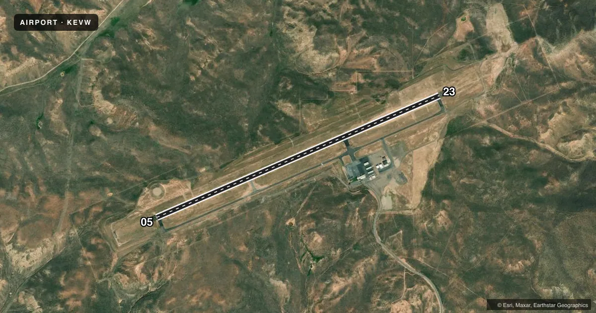
Runways & pattern
Full pagePattern entry · RWY 23
LEFT TRAFFICRunway end performance
| End | TORA | TODA | ASDA | LDA | VGSI | Approach lights | Obstruction |
|---|---|---|---|---|---|---|---|
| 05 | — | — | — | — | PAPI 4-box left(3°) | — | — |
| 23 | — | — | — | — | PAPI 4-box left(3°) | MALSR | — |
Declared distances in feet. TORA = takeoff run available, TODA = takeoff distance, ASDA = accelerate-stop, LDA = landing distance.
Airport sketch
Runways drawn to scale from FAA survey coordinates, rendered over satellite imagery. Not for navigation.
Approaches & charts
ILS · 1
Services on the field
Fuel grades, oxygen, maintenance, ramp storage and lighting — as declared to the FAA by the airport operator.
Fuel & services
- Fuel
- 100LLA
- Oxygen (bottled)
- Not available
- Oxygen (bulk)
- Low pressure
- Airframe repair
- Major
- Power plant repair
- Major
Ramp & ground
- Transient storage
- Tie-down
- Hangar
- Landing fee
- No fee published
- Lighting schedule
- SEE RMK
- Beacon schedule
- SS-SR
- Beacon
- White / Green (civil land)(WG)
- Wind indicator
- Lighted
- Segmented circle
- Yes
Fuel & FBOs
Cheapest 100LL and Jet A on the field and nearby. Always confirm with the FBO before taxi.
Airport notes
Surface conditions, obstructions, local procedures, lighting outages and other notes published with each FAA cycle.
General notes
- GCO AVBL ON FREQ 121.72 THRU SALT LAKE ARTCC CD, CASPER FSS NOT AVBL.
- FOR CD IF UNA VIA GCO CTC SALT LAKE ARTCC AT 801-320-2568.
Lighting notes
- ACTVT MALSR RWY 23; REIL RWY 05; HIRL RWY 05/23 - CTAF. RWY 05/23 PAPIS ON CONSLY.
Runway surface & condition
- 05/23PCR VALUE: 295/F/D/X/T
Other notes
- DETERMINATION PENDING.
- ARPT CHRGS FAC FEE.
- 1FOR SVC AFT HRS CALL 1-307-789-2256.
- OWNERCOUNTY OF UINTA.
VFR map & nearby airports
VFR sectional. Tap any ICAO chip to open that airport.
Key facts · KEVW
Answer card- ICAO
- KEVW
- Name
- EVANSTON-UINTA COUNTY BURNS FLD
- Location
- EVANSTON, WYOMING
- Elevation
- 7,142.7 ft MSL
- Traffic pattern altitude
- 8,142.7 ft MSL (1,000 AGL)
- Control tower
- Non-towered (use CTAF)
- Total runways
- 1
- Longest runway
- 05/23 · 7,300 ft
- Published ILS approaches
- 1
- Published frequencies
- 2
- Magnetic variation
- 13°
- Current flight rules
- VFR
- Current wind
- 180° at 4 kt
- Favored runway now
- RWY 23
Evanston-Uinta County Burns Fld (KEVW) sits in Evanston, Wyoming. The field elevation is 7,142.7 ft MSL, so performance planning matters here. There is one runway. Runway 05/23 is 7,300 ft long with an asphalt surface. The airport is non-towered. CTAF and UNICOM are both 123.0. The published pattern altitude is not listed, so use the standard 1,000 ft AGL pattern unless the current Chart Supplement says otherwise.
An ILS is available for runway 23. Runway 23 also has MALSR lighting. Runway 05 has REILs. High intensity runway lights are installed on both runway ends and are controlled by CTAF. PAPI is on continuously for 05/23. That setup helps at night and in lower visibility. You still need to confirm the current procedure before you go.
Evanston Aviation is the on-field FBO. It carries 100LL, Jet A and Jet A Prist. For after-hours service, the published number is (307) 789-2256. The airport is in a high-elevation mountain setting, so expect thinner air and longer takeoff rolls. Ground communications outlet service is available through Salt Lake Air Route Traffic Control Center. Casper Flight Service Station is not available. Check the current Chart Supplement for the facility fee note and any other local operating details before departure.