METAR & TAF KEMM
Current METAR
Observed 11:35Z
KEMM 271135Z AUTO 34006KT 10SM SCT100 19/05 A3030 RMK AO2
- Wind
- 340° @ 6 kt
- Visibility
- 10 SM
- Temp / Dew
- 19°C / 5°C
- Altimeter
- 30.30 inHg
- Clouds
- SCT
- Density alt
- 9,047 ft
- Ceiling
- Unlimited
- Rules
- VFR
Airport info & contacts
Manager on record, flight service, ARTCC, attendance schedule and pattern altitude — published by the FAA and refreshed every 28 days.
Location
- From city
- 2 NM NW
- VFR sectional
- SALT LAKE CITY
- ARTCC
- ZLC · SALT LAKE CITY
- NOTAM facility
- CPR (NOTAM-D)
Airport manager
- Name
- CHAD NIELSON
- Phone
- 307-727-7856
- Address
- 220 WYO HIWAY. 233, KEMMERER WY 83101
Flight service · Hours
- FSS CPR
- CASPER1-800-WX-BRIEF
- Attendance
- Unattended
Frequencies
Tap any row to copy the frequency to your clipboard.
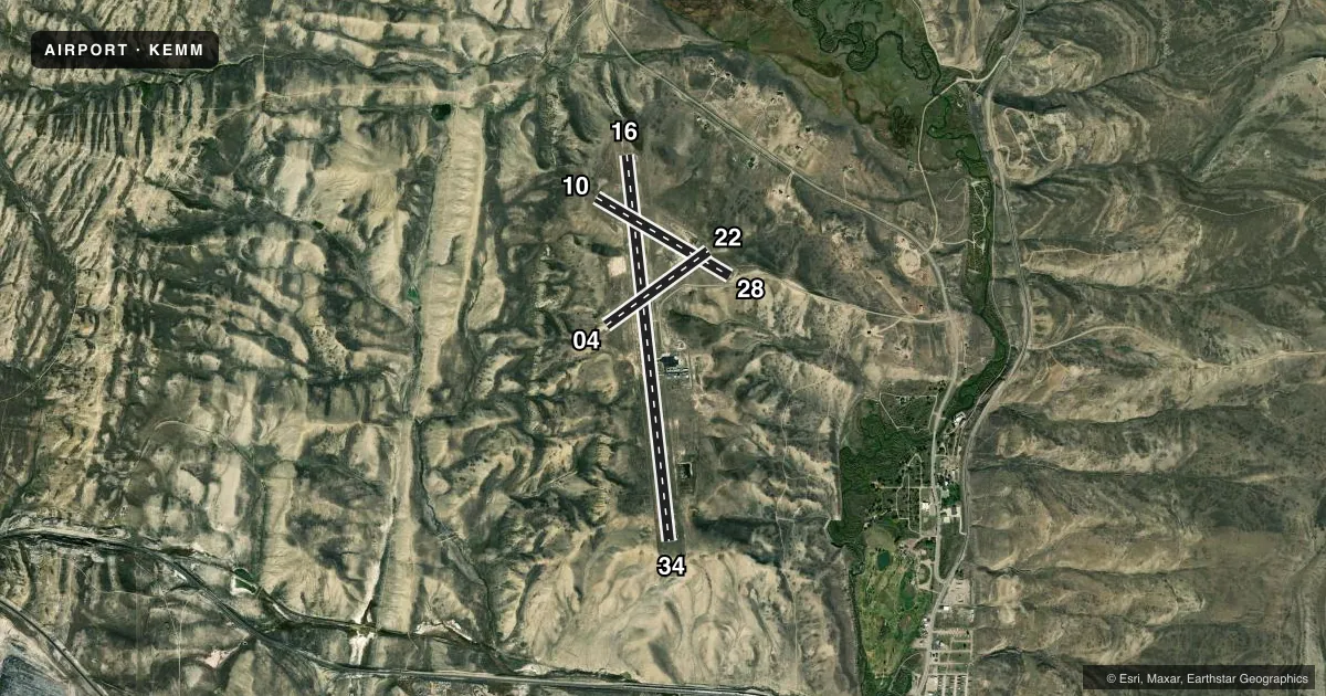
Runways & pattern
Full pagePattern entry · RWY 34
LEFT TRAFFIC| Runway | Heading (°M) | Length | Surface | Traffic |
|---|---|---|---|---|
| 16/34Favored | 163° / 343° | 8,203 ft | ASPH | Standard L |
| 10/28 | 110° / 290° | 3,271 ft | TURF-DIRT | Standard L |
| 04/22 | 43° / 223° | 2,671 ft | CONC | 22 R |
Runway end performance
| End | TORA | TODA | ASDA | LDA | VGSI | Approach lights | Obstruction |
|---|---|---|---|---|---|---|---|
| 16 | — | — | — | — | PAPI 2-box left(3.25°) | — | — |
| 34 | — | — | — | — | PAPI 2-box left(3.25°) | — | — |
| 28 | — | — | — | — | — | — | 7', fence, 105' from thr, 0' R of cntrln, slope 16 |
Declared distances in feet. TORA = takeoff run available, TODA = takeoff distance, ASDA = accelerate-stop, LDA = landing distance.
Airport sketch
Runways drawn to scale from FAA survey coordinates, rendered over satellite imagery. Not for navigation.
Approaches & charts
Services on the field
Fuel grades, oxygen, maintenance, ramp storage and lighting — as declared to the FAA by the airport operator.
Fuel & services
- Fuel
- 100LLA
- Oxygen (bottled)
- Not available
- Oxygen (bulk)
- Not available
- Airframe repair
- Not available
- Power plant repair
- Not available
Ramp & ground
- Transient storage
- Tie-down
- Hangar
- Landing fee
- No fee published
- Customs
- Not available
- Lighting schedule
- SEE RMK
- Beacon schedule
- SS-SR
- Beacon
- White / Green (civil land)(WG)
- Wind indicator
- Lighted
- Segmented circle
- Yes
Fuel & FBOs
Cheapest 100LL and Jet A on the field and nearby. Always confirm with the FBO before taxi.
Airport notes
Surface conditions, obstructions, local procedures, lighting outages and other notes published with each FAA cycle.
General notes
- TERRAIN DROPS OFF STEEPLY 81' PRIOR TO APCH END RY 4.
- TERRAIN DROPS OFF STEEPLY 55' PRIOR TO APCH END RY 10.
- FOR CD CTC SALT LAKE ARTCC AT 801-320-2568.
Lighting notes
- ACTVT REIL RWYS 16 & 34; PAPI RWYS 16 & 34; MIRL RWYS 04/22 & 16/34 - CTAF.
Fuel notes
- 100LLFUEL AVBL H24 VIA SELF SVC CREDIT CARD READER LCTD INSIDE PILOT LOUNGE EAST DOOR.
Other notes
- SEGMENTED CIRCLE DOES NOT DEPICT RIGHT HAND TRAFFIC FOR RY 22.
- PILOT SPLD TIE DOWN ROPES RQRD.
- OWNERALSO LINCOLN COUNTY - 307-877-9056
- MANAGERFOR ASSISTANCE AFT HRS PHONE 307-727-7856
VFR map & nearby airports
VFR sectional. Tap any ICAO chip to open that airport.
Key facts · KEMM
Answer card- ICAO
- KEMM
- Name
- KEMMERER MUNI
- Location
- KEMMERER, WYOMING
- Elevation
- 7,288.7 ft MSL
- Traffic pattern altitude
- 8,288.7 ft MSL (1,000 AGL)
- Control tower
- Non-towered (use CTAF)
- Total runways
- 3
- Longest runway
- 16/34 · 8,203 ft
- Published ILS approaches
- 0
- Published frequencies
- 2
- Magnetic variation
- 11°
- Current flight rules
- VFR
- Current wind
- 340° at 6 kt
- Favored runway now
- RWY 34
Kemmerer Muni sits in Kemmerer, Wyoming at 7,288.7 ft MSL. It is a high-elevation field with three runways. The longest is runway 16/34 at 8,203 ft asphalt. Runway 04/22 is concrete at 2,671 ft. Runway 10/28 is turf-dirt at 3,271 ft. There is no control tower. Use CTAF 122.8 for traffic. No ILS approaches are published here.
The pattern altitude is not published. Use the standard 1,000 ft AGL for light piston aircraft unless the current FAA Chart Supplement says otherwise. That puts the working pattern picture at about 8,289 ft MSL. The airport publishes runway lights on 16/34 and 04/22. Runways 16 and 34 also have runway end identifier lights and precision approach path indicators. Fuel is available 24 hours a day through a self-serve credit card reader in the pilot lounge east door. The on-field FBO is Kemmerer Municipal Airport. It carries 100LL and Jet A.
This is a mountain airport with steep terrain near the approach ends of runways 4 and 10. That matters on arrival and departure. Check density altitude before you go. Also note the published traffic note for runway 22. The segmented circle does not show right-hand traffic for that runway. For clearance delivery, contact Salt Lake ARTCC. If you need after-hours help, call the manager number in the Chart Supplement or the airport operator.