METAR & TAF 48U
48U does not publish a METAR.
Showing the nearest reporting station: KRKS (SOUTHWEST WYOMING RGNL) · 20.8 NM away. Conditions at 48U may differ.
METAR · KRKS
Observed 02:54Z
KRKS 250254Z AUTO 10007KT 10SM FEW120 26/05 A3026 RMK AO2 SLP144 T02610050 51008
- Wind
- 100° @ 7 kt
- Visibility
- 10 SM
- Temp / Dew
- 26°C / 5°C
- Altimeter
- 30.26 inHg
- Clouds
- FEW
- Density alt
- 9,804 ft
- Ceiling
- Unlimited
- Rules
- VFR
Airport info & contacts
Manager on record, flight service, ARTCC, attendance schedule and pattern altitude — published by the FAA and refreshed every 28 days.
Location
- From city
- 4 NM S
- VFR sectional
- SALT LAKE CITY
- ARTCC
- ZLC · SALT LAKE CITY
- NOTAM facility
- CPR (NOTAM-D)
Airport manager
- Name
- MARK WESTENSKOW
- Phone
- 307-872-0525
- Address
- 50 E 2ND N, GREEN RIVER WY 82935
Flight service · Hours
- FSS CPR
- CASPER1-800-WX-BRIEF
- Attendance
- Unattended
Frequencies
Tap any row to copy the frequency to your clipboard.
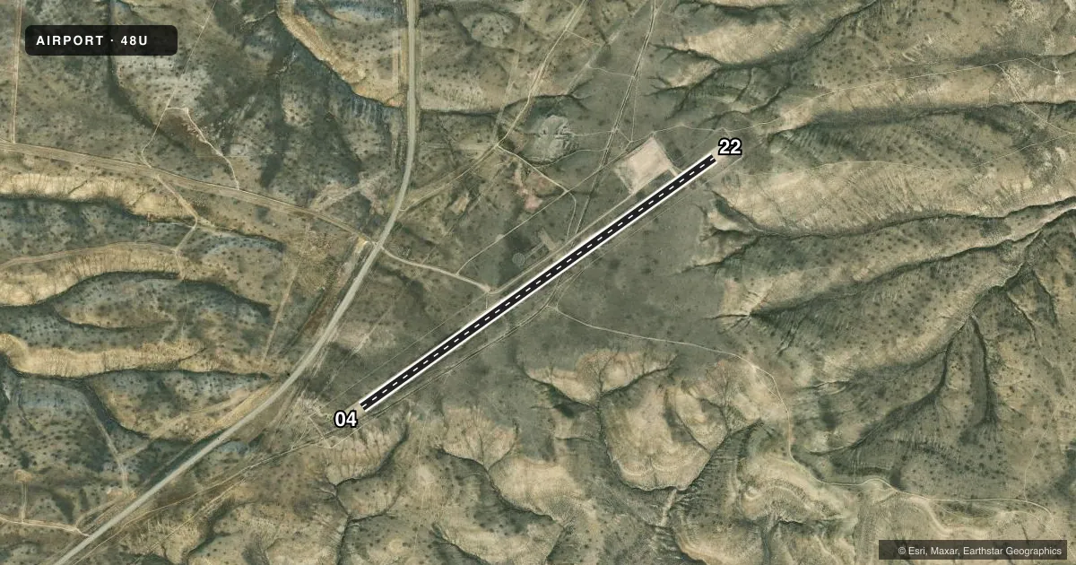
Runways & pattern
Full pagePattern entry · RWY 04
LEFT TRAFFICAirport sketch
Runways drawn to scale from FAA survey coordinates, rendered over satellite imagery. Not for navigation.
Approaches & charts
Services on the field
Fuel grades, oxygen, maintenance, ramp storage and lighting — as declared to the FAA by the airport operator.
Fuel & services
- Fuel
- Not available
- Oxygen (bottled)
- Not available
- Oxygen (bulk)
- Not available
- Airframe repair
- Not available
- Power plant repair
- Not available
Ramp & ground
- Transient storage
- Not published
- Landing fee
- No fee published
- Customs
- Not available
- Wind indicator
- Yes
- Segmented circle
- Yes
Fuel & FBOs
Cheapest 100LL and Jet A on the field and nearby. Always confirm with the FBO before taxi.
Airport notes
Surface conditions, obstructions, local procedures, lighting outages and other notes published with each FAA cycle.
General notes
- RY SOFT WHEN WET.
- NO SNOW REMOVAL AVAILABLE.
- FOR CD CTC SALT LAKE ARTCC AT 801-320-2568.
Approach & departure obstructions
- 04RWY END AND EDGE DELINEATED USING CONE MKRS.
- 22RWY END AND EDGE DELINEATED USING CONE MKRS.
VFR map & nearby airports
VFR sectional. Tap any ICAO chip to open that airport.
Key facts · 48U
Answer card- ICAO
- 48U
- Name
- GTR GREEN RIVER INTERGALACTIC SPACEPORT
- Location
- GREEN RIVER, WYOMING
- Elevation
- 7,182 ft MSL
- Traffic pattern altitude
- 8,182 ft MSL (1,000 AGL)
- Control tower
- Non-towered (use CTAF)
- Total runways
- 1
- Longest runway
- 04/22 · 5,652 ft
- Published ILS approaches
- 0
- Published frequencies
- 1
- Magnetic variation
- 14°
- Current flight rules
- VFR
- Current wind
- 100° at 7 kt
- Favored runway now
- RWY 04
48U sits in Green River, Wyoming. Field elevation is 7,182 ft MSL. The airport has one runway. Runway 04/22 is 5,652 ft long and surfaced with dirt. The field is not towered. CTAF is 122.9. No ILS approaches are published.
Pattern altitude is not published. Use the standard 1,000 ft AGL pattern for light piston operations unless the current Chart Supplement says otherwise. The published remarks also matter here. There is no snow removal available. The runway is soft when wet. Cone markers define the runway ends and edges on both 04 and 22. Clearance delivery is handled through Salt Lake ARTCC at 801-320-2568.
This is a high-elevation strip at 7,182 ft MSL. Expect density altitude to be a real factor, especially on warm days. Plan performance carefully. With one dirt runway and no published ILS, a first-time pilot should brief the surface condition. Brief the wind too. Brief the departure performance before committing. Check the current FAA Chart Supplement for any updated procedures or restrictions before you go.