METAR & TAF KRKS
Current METAR
Observed 12:54Z
KRKS 271254Z AUTO 15003KT 10SM FEW120 24/07 A3024 RMK AO2 SLP126 T02390067
- Wind
- 150° @ 3 kt
- Visibility
- 10 SM
- Temp / Dew
- 24°C / 7°C
- Altimeter
- 30.24 inHg
- Clouds
- FEW
- Density alt
- 9,071 ft
- Ceiling
- Unlimited
- Rules
- VFR
Airport info & contacts
Manager on record, flight service, ARTCC, attendance schedule and pattern altitude — published by the FAA and refreshed every 28 days.
Location
- From city
- 7 NM E
- VFR sectional
- SALT LAKE CITY
- ARTCC
- ZLC · SALT LAKE CITY
- NOTAM facility
- RKS (NOTAM-D)
Airport manager
- Name
- DEVON BRUBAKER
- Phone
- 307-352-6880
- Address
- 382 HWY 370, ROCK SPRINGS WY 82901-1987
Flight service · Hours
- FSS CPR
- CASPER1-800-WX-BRIEF
- Attendance
- 0400-2200
Frequencies
Tap any row to copy the frequency to your clipboard.
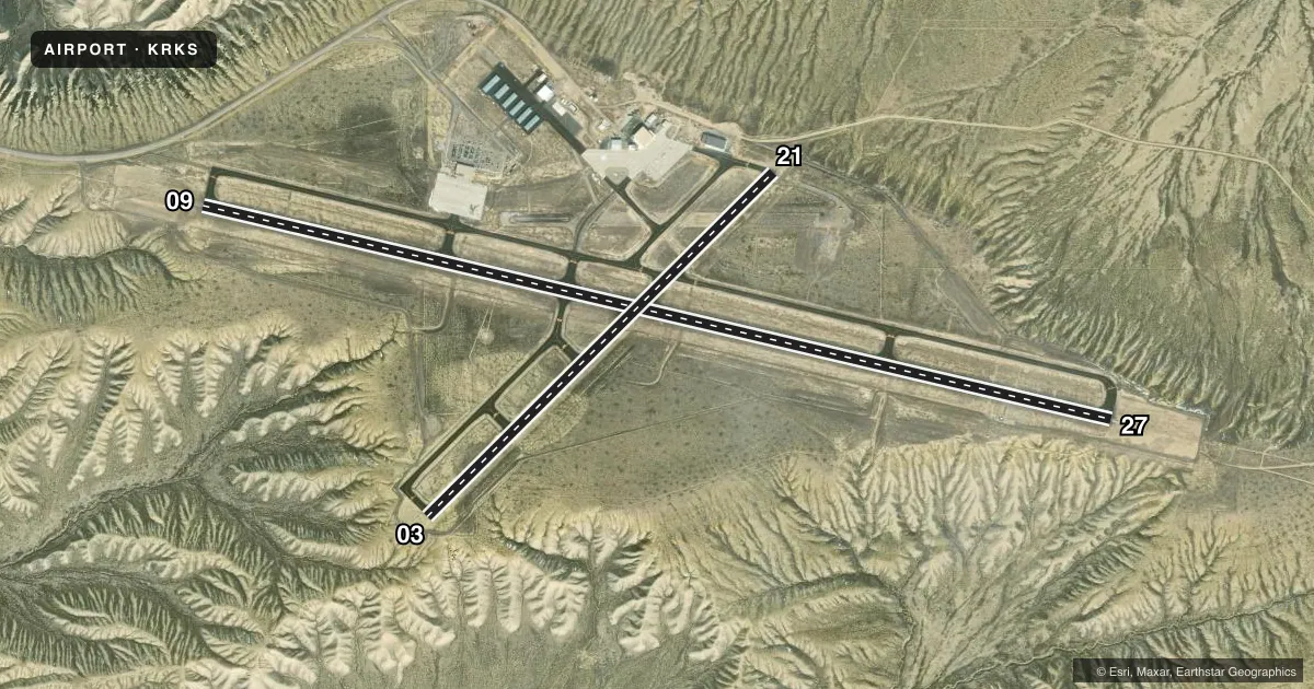
Runways & pattern
Full pagePattern entry · RWY 09
LEFT TRAFFIC| Runway | Heading (°M) | Length | Surface | Traffic |
|---|---|---|---|---|
| 09/27Favored | 90° / 270° | 10,002 ft | ASPH | Standard L |
| 03/21 | 32° / 212° | 5,228 ft | ASPH | Standard L |
Runway end performance
| End | TORA | TODA | ASDA | LDA | VGSI | Approach lights | Obstruction |
|---|---|---|---|---|---|---|---|
| 09 | 10,002' | 10,002' | 10,002' | 10,002' | PAPI 4-box left(3°) | ODALS | — |
| 27 | 10,002' | 10,002' | 10,002' | 10,002' | PAPI 4-box left(3°) | MALSR | — |
| 03 | 5,228' | 5,228' | 5,228' | 5,228' | PAPI 2-box left(3°) | — | — |
| 21 | 5,228' | 5,228' | 5,228' | 5,228' | PAPI 2-box left(3°) | — | — |
Declared distances in feet. TORA = takeoff run available, TODA = takeoff distance, ASDA = accelerate-stop, LDA = landing distance.
Airport sketch
Runways drawn to scale from FAA survey coordinates, rendered over satellite imagery. Not for navigation.
Approaches & charts
ILS · 1
Services on the field
Fuel grades, oxygen, maintenance, ramp storage and lighting — as declared to the FAA by the airport operator.
Fuel & services
- Fuel
- 100LLA1+
- Oxygen (bottled)
- HIGH/LOW
- Airframe repair
- Minor
- Power plant repair
- Minor
- Other services
- AFRT,AMB,CARGO,CHTR,INSTR,RNTL
Ramp & ground
- Transient storage
- Tie-down
- Hangar
- Landing fee
- No fee published
- Customs
- Not available
- Lighting schedule
- SEE RMK
- Beacon schedule
- SS-SR
- Beacon
- White / Green (civil land)(WG)
- Wind indicator
- Lighted
- Segmented circle
- Yes
Fuel & FBOs
Cheapest 100LL and Jet A on the field and nearby. Always confirm with the FBO before taxi.
Airport notes
Surface conditions, obstructions, local procedures, lighting outages and other notes published with each FAA cycle.
General notes
- FOR CD IF UNA TO CTC ON FSS FREQ, CTC SALT LAKE ARTCC AT 801-320-2568.
Lighting notes
- ACTVT MALSR RWY 27; ODALS RWY 09; REIL RWY 03 & 21; HIRL RWY 09/27 & TWY LGTS - CTAF. PAPI RWY 09, 27, 03, 21 OPR CONSLY.
Runway surface & condition
- 03/21PCR VALUE: 112/F/D/X/T
- 09/27PCR VALUE: 1557/F/A/X/T
Other notes
- EXISTED PRIOR TO 1959.
- PPR FOR ACR OPS WITH MORE THAN 30 PAX SEATS 2200-0400 CALL ARPT OPS 307-352-6888. ARFF INDEX C AVBL WITH 30 MIN NOTICE: CALL ARPT OPS 307-352-6888.
- OWNERROCK SPRINGS/SWEETWATER CO ARPT JOINT PWRS BOARDS.
VFR map & nearby airports
VFR sectional. Tap any ICAO chip to open that airport.
Key facts · KRKS
Answer card- ICAO
- KRKS
- Name
- SOUTHWEST WYOMING RGNL
- Location
- ROCK SPRINGS, WYOMING
- Elevation
- 6,764.6 ft MSL
- Traffic pattern altitude
- 7,764.6 ft MSL (1,000 AGL)
- Control tower
- Non-towered (use CTAF)
- Total runways
- 2
- Longest runway
- 09/27 · 10,002 ft
- Published ILS approaches
- 1
- Published frequencies
- 2
- Magnetic variation
- 13°
- Current flight rules
- VFR
- Current wind
- 150° at 3 kt
- Favored runway now
- RWY 09
Southwest Wyoming Rgnl Airport sits in Rock Springs, Wyoming. The field elevation is 6,764.6 ft MSL, so performance planning matters here. The airport has two asphalt runways. The longest is 09/27 at 10,002 ft. Runway 03/21 is 5,228 ft. There is no control tower. CTAF and UNICOM are both 122.8.
An ILS approach is available to runway 27. Lighting is useful here after dark. MALSR is active on 27. ODALS is available on 09. REIL is available on 03 and 21. PAPI is published for all four runway ends and operates continuously. The published pattern altitude is not listed, so use the standard 1,000 ft AGL for light piston traffic unless the current FAA Chart Supplement says otherwise. That puts pattern altitude at about 7,765 ft MSL.
Sweetwater Aviation is on the field. It carries 100LL and Jet A. For clearance delivery, if you cannot reach Flight Service, the published remark says to contact Salt Lake ARTCC. This is a high-elevation airport in southwest Wyoming. Expect density altitude to matter, especially on warm days. Check the current FAA Chart Supplement for any updated remarks before you go.