METAR & TAF TF9
TF9 does not publish a METAR.
Showing the nearest reporting station: KVEL (VERNAL RGNL) · 31.4 NM away. Conditions at TF9 may differ.
METAR · KVEL
Observed 11:53Z
KVEL 271153Z AUTO 34003KT 10SM FEW100 24/10 A3012 RMK AO2 SLP110 T02440100 10289 20233 53001 $
- Wind
- 340° @ 3 kt
- Visibility
- 10 SM
- Temp / Dew
- 24°C / 10°C
- Altimeter
- 30.12 inHg
- Clouds
- FEW
- Density alt
- 7,823 ft
- Ceiling
- Unlimited
- Rules
- VFR
Airport info & contacts
Manager on record, flight service, ARTCC, attendance schedule and pattern altitude — published by the FAA and refreshed every 28 days.
Location
- From city
- 11 NM ESE
- VFR sectional
- SALT LAKE CITY
- ARTCC
- ZLC · SALT LAKE CITY
Airport manager
- Name
- STEVE DURTSCHI - UBCP
- Phone
- 385-220-5313
- Address
- 1887 SOUTH REDWOOD ROAD, UNIT 16, WOODS CROSS UT 84087
Flight service · Hours
- FSS CDC
- CEDAR CITY1-800-WX-BRIEF
Frequencies
Tap any row to copy the frequency to your clipboard.
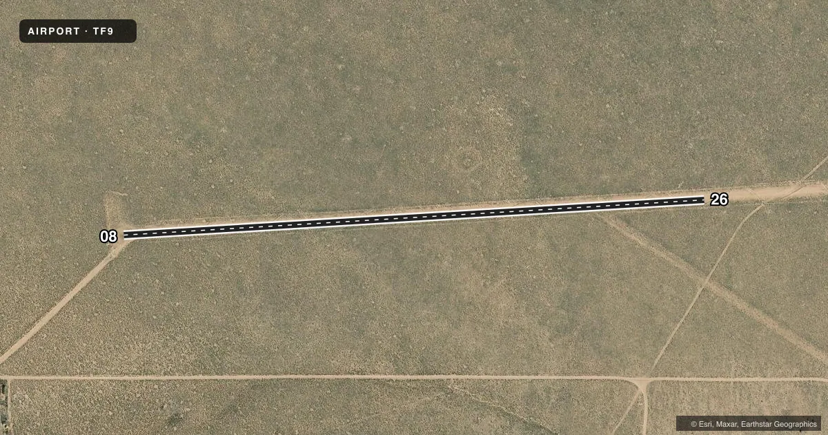
Runways & pattern
Full pagePattern entry · RWY 26
LEFT TRAFFICAirport sketch
Runways drawn to scale from FAA survey coordinates, rendered over satellite imagery. Not for navigation.
Approaches & charts
Services on the field
Fuel grades, oxygen, maintenance, ramp storage and lighting — as declared to the FAA by the airport operator.
Fuel & services
- Fuel
- Not available
Ramp & ground
- Transient storage
- Not published
- Segmented circle
- No
Fuel & FBOs
Cheapest 100LL and Jet A on the field and nearby. Always confirm with the FBO before taxi.
Airport notes
Surface conditions, obstructions, local procedures, lighting outages and other notes published with each FAA cycle.
Other notes
- OWNERATTN: MATT TIPPETS
VFR map & nearby airports
VFR sectional. Tap any ICAO chip to open that airport.
Key facts · TF9
Answer card- ICAO
- TF9
- Name
- TAYLOR FLAT
- Location
- DUTCH JOHN, UTAH
- Elevation
- 5,638 ft MSL
- Traffic pattern altitude
- 6,638 ft MSL (1,000 AGL)
- Control tower
- Non-towered (use CTAF)
- Total runways
- 1
- Longest runway
- 08/26 · 2,500 ft
- Published ILS approaches
- 0
- Published frequencies
- 0
- Magnetic variation
- –
- Current flight rules
- VFR
- Current wind
- 340° at 3 kt
- Favored runway now
- RWY 26
Taylor Flat (TF9) sits near Dutch John, Utah. Field elevation is 5,638 ft MSL. It has one runway. The longest runway is 08/26 at 2,500 ft on dirt. This is a non-towered field, so plan for self-announce traffic and normal see-and-avoid work in the pattern.
No ILS approaches are published here. Pattern altitude is not published, so use the standard 1,000 ft AGL pattern for light piston operations unless the current FAA Chart Supplement says otherwise. With the field sitting at 5,638 ft MSL, density altitude can be a real factor on warm days. Expect longer takeoff rolls and a slower climb than you would see at lower elevation fields. Runway headings are listed as magnetic in the airport data. The published headings are 08 and 26.
No on-field FBOs are listed. That means fuel and service options need to be verified before you go. Check the current FAA Chart Supplement or call the airport operator directly for the latest operational details. The published remarks include a note for Matt Tippets, so verify any local coordination details before arrival. This is a small, high-elevation dirt strip. A first-time pilot should treat it as a performance planning airport and confirm runway condition, winds and surface condition before committing.