METAR & TAF 4V0
Current METAR
Observed 01:15Z
K4V0 270115Z AUTO 19005KT 10SM CLR 36/06 A3006 RMK AO2 T03620060
- Wind
- 190° @ 5 kt
- Visibility
- 10 SM
- Temp / Dew
- 36°C / 6°C
- Altimeter
- 30.06 inHg
- Clouds
- CLR
- Density alt
- 8,891 ft
- Ceiling
- Unlimited
- Rules
- VFR
Airport info & contacts
Manager on record, flight service, ARTCC, attendance schedule and pattern altitude — published by the FAA and refreshed every 28 days.
Location
- From city
- 2 NM E
- VFR sectional
- CHEYENNE
- ARTCC
- ZDV · DENVER
- NOTAM facility
- DEN (NOTAM-D)
Airport manager
- Name
- ZACHARY GUTHRIE
- Phone
- 970-549-7709
- Address
- 2248 E MAIN, RANGELY CO 81648
Flight service · Hours
- FSS DEN
- DENVER1-800-WX-BRIEF
- Attendance
- 0800-1700
Frequencies
Tap any row to copy the frequency to your clipboard.
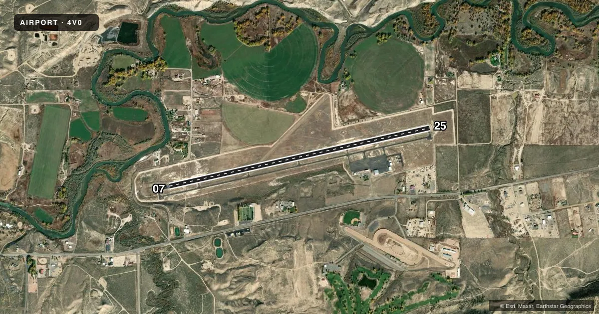
Runways & pattern
Full pagePattern entry · RWY 25
LEFT TRAFFICRunway end performance
| End | TORA | TODA | ASDA | LDA | VGSI | Approach lights | Obstruction |
|---|---|---|---|---|---|---|---|
| 07 | — | — | — | — | PAPI 2-box left(3°) | — | — |
Declared distances in feet. TORA = takeoff run available, TODA = takeoff distance, ASDA = accelerate-stop, LDA = landing distance.
Airport sketch
Runways drawn to scale from FAA survey coordinates, rendered over satellite imagery. Not for navigation.
Approaches & charts
Services on the field
Fuel grades, oxygen, maintenance, ramp storage and lighting — as declared to the FAA by the airport operator.
Fuel & services
- Fuel
- 100LL
- Oxygen (bottled)
- Not available
- Oxygen (bulk)
- Not available
- Airframe repair
- Not available
- Power plant repair
- Not available
- Other services
- INSTR
Ramp & ground
- Transient storage
- Tie-down
- Landing fee
- No fee published
- Customs
- Not available
- Lighting schedule
- SEE RMK
- Beacon schedule
- SS-SR
- Beacon
- White / Green (civil land)(WG)
- Wind indicator
- Lighted
- Segmented circle
- Yes
Fuel & FBOs
Cheapest 100LL and Jet A on the field and nearby. Always confirm with the FBO before taxi.
Airport notes
Surface conditions, obstructions, local procedures, lighting outages and other notes published with each FAA cycle.
General notes
- THREE FLASHING HAZ BCNS OUTLINE OBSTN HILLS E.
- DEER PERIODICALLY ON & INVOF ARPT.
- TWY MARKED WITH BLUE REFLECTORS.
- RWY 07/25 SHOULDERS SOFT WHEN WET.
- RWY 07 HAS 8 FT FENCE LINE 520 FT FM THLD OB, 66 FT TREES 2500 FT FM THLD 600 FT LEFT OF CNTRLN.
- RWY 25 HAS 10 FT FENCE LINE 615 FT FM THLD OB.
- FOR CD IF UNA TO CTC ON FSS FREQ, CTC DENVER ARTCC AT 303-651-4257.
- COLD TEMPERATURE AIRPORT. ALTITUDE CORRECTION REQUIRED AT OR BELOW -17C.
- NMRS PRAIRIE DOG HOLES ON AND INVOF RWY SAFETY AREAS.
Lighting notes
- ACTVT REIL RWY 07 & 25; MIRL RWY 07/25 - CTAF. PAPI RWY 07 OPER 24 HRS.
Fuel notes
- 100LLSELF SVC FUEL AVBL WITH CREDIT CARD.
Other notes
- MINOR EMERGENCY SERVICES UPON REQUEST.
- AUTOMATED UNICOM.
- 1FOR SERVCIE CALL 970-675-2316
VFR map & nearby airports
VFR sectional. Tap any ICAO chip to open that airport.
Key facts · 4V0
Answer card- ICAO
- 4V0
- Name
- RANGELY
- Location
- RANGELY, COLORADO
- Elevation
- 5,278 ft MSL
- Traffic pattern altitude
- 6,278 ft MSL (1,000 AGL)
- Control tower
- Non-towered (use CTAF)
- Total runways
- 1
- Longest runway
- 07/25 · 6,409 ft
- Published ILS approaches
- 0
- Published frequencies
- 2
- Magnetic variation
- 10°
- Current flight rules
- VFR
- Current wind
- 190° at 5 kt
- Favored runway now
- RWY 25
Rangely Airport (4V0) sits in Rangely, Colorado at 5,278 ft MSL. It has one runway, 07/25, which is 6,409 ft long and asphalt. There is no control tower. CTAF and UNICOM are both 122.8. No ILS approaches are published here.
The pattern altitude is not published. Use the standard 1,000 ft AGL pattern unless the current Chart Supplement says otherwise. That puts the light aircraft pattern at 6,278 ft MSL based on the field elevation. Pilots should pay attention to the published remarks. Runway 25 has a fence line 615 ft from the threshold. Runway 07 has an 8 ft fence line 520 ft from the threshold. It also has 66 ft trees about 2,500 ft from the threshold and 600 ft left of centerline. Prairie dog holes, deer and soft shoulders when wet are also noted.
Rangley Airport has one on-field FBO. Rangley Airport carries 100LL. Self-service fuel is available with credit card. The field is a cold temperature airport. Altitude correction is required at or below minus 17 degrees Celsius. Automated UNICOM is available. Taxiways are marked with blue reflectors. For clearance delivery, if you cannot reach Flight Service, contact Denver ARTCC at 303-651-4257.