METAR & TAF KRIL
Current METAR
Observed 10:53Z
KRIL 271053Z AUTO 12004KT 10SM CLR 20/10 A3019 RMK AO2 SLP137 T02000100
- Wind
- 120° @ 4 kt
- Visibility
- 10 SM
- Temp / Dew
- 20°C / 10°C
- Altimeter
- 30.19 inHg
- Clouds
- CLR
- Density alt
- 7,131 ft
- Ceiling
- Unlimited
- Rules
- VFR
Airport info & contacts
Manager on record, flight service, ARTCC, attendance schedule and pattern altitude — published by the FAA and refreshed every 28 days.
Location
- From city
- 3 NM E
- VFR sectional
- DENVER
- ARTCC
- ZDV · DENVER
- NOTAM facility
- RIL (NOTAM-D)
Airport manager
- Name
- SAM CARVER
- Phone
- 970-625-1091
- Address
- 0375 COUNTY RD 352 BLDG 2060, RIFLE CO 81650
Flight service · Hours
- FSS DEN
- DENVER1-800-WX-BRIEF
- Attendance
- ALL
Frequencies
Tap any row to copy the frequency to your clipboard.
Runways & pattern
Full pagePattern entry · RWY 08
LEFT TRAFFICRunway end performance
| End | TORA | TODA | ASDA | LDA | VGSI | Approach lights | Obstruction |
|---|---|---|---|---|---|---|---|
| 08 | — | — | — | — | PAPI 4-box left(3°) | — | 6', tower, 331' from thr, 307' R of cntrln, slope 21 |
| 26 | — | — | — | — | PAPI 4-box left(3.5°) | ODALS | — |
Declared distances in feet. TORA = takeoff run available, TODA = takeoff distance, ASDA = accelerate-stop, LDA = landing distance.
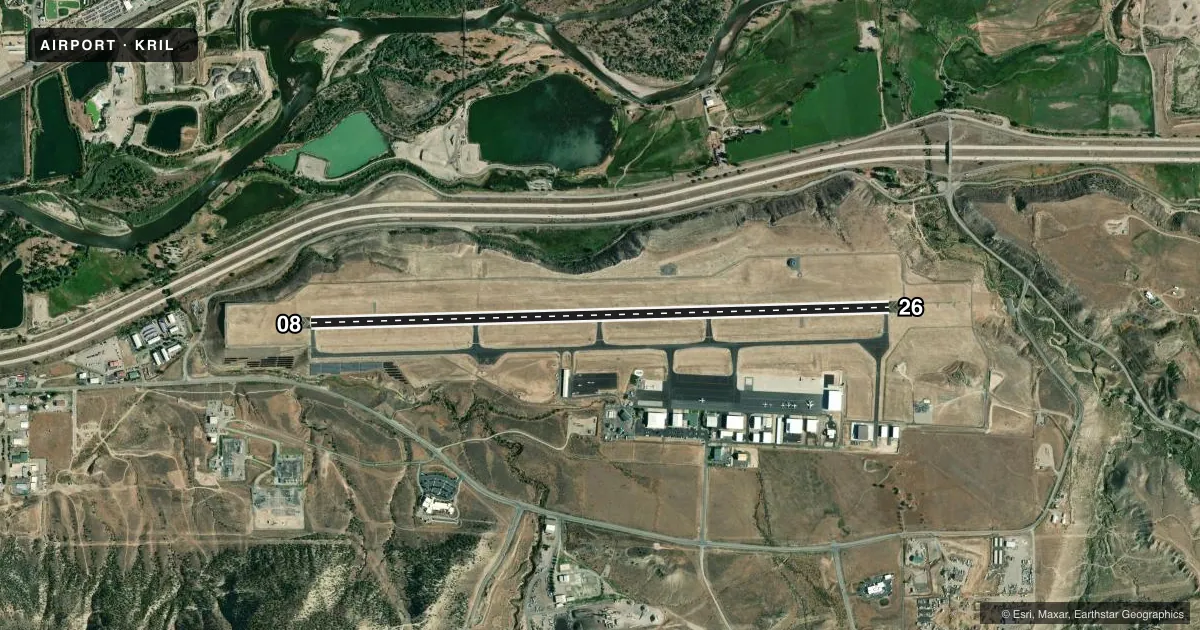
Airport sketch
Runways drawn to scale from FAA survey coordinates, rendered over satellite imagery. Not for navigation.
Approaches & charts
ILS · 1
Services on the field
Fuel grades, oxygen, maintenance, ramp storage and lighting — as declared to the FAA by the airport operator.
Fuel & services
- Fuel
- 100LLA
- Oxygen (bottled)
- Low pressure
- Oxygen (bulk)
- High pressure
- Airframe repair
- Major
- Power plant repair
- Major
- Other services
- AFRT,AMB,CHTR,INSTR,RNTL
Ramp & ground
- Transient storage
- Tie-down
- Hangar
- Landing fee
- No fee published
- Customs
- Not available
- Lighting schedule
- SEE RMK
- Beacon schedule
- SS-SR
- Beacon
- White / Green (civil land)(WG)
- Wind indicator
- Lighted
- Segmented circle
- Yes
Fuel & FBOs
Cheapest 100LL and Jet A on the field and nearby. Always confirm with the FBO before taxi.
Airport notes
Surface conditions, obstructions, local procedures, lighting outages and other notes published with each FAA cycle.
General notes
- AFT WINTER SN STORMS ARPT OPNS BFR ALL TWYS ARE CLEARED.
- OVNGT PRKG FEE.
- COLD TEMPERATURE AIRPORT. ALTITUDE CORRECTION REQUIRED AT OR BELOW -13C.
- FOR CD, IFUN TO CTC ON DENVER ARTCC APP/DEP CTL FREQ, CTC DENVER ARTCC AT 303-651-4257.
- GLD OPS INVOF ARPT.
- PROPER DUAL RDO USE (ATC/CTAF) IS ESNTL FOR SAFE AND EFFICIENT TFC FLOW.
- USE CTAF PRIOR TO ENTERING RWY OR PAT.
- IFR ATC CLNC FM RIL IS NOT AUTH TO ENTER RWY OR TKOF & LNDG.
- SATURATED PAT POLICY: TGLS PROHIBITED WHEN 5 OR MORE ACFT IN TFC PATTERN.
- FLW FAA PROCS FOR NON-TOWERED ARPTS.
- CTN: SN REMOVAL EQUIP OPS FM 1 OCT TO 15 MAY.
Lighting notes
- ACTVT ODALS RWY 26; REIL RWY 08; HIRL RWY 08/26 - CTAF. PAPI RWY 08 & 26 ON CONSLY.
Fuel notes
- 100LLARPT OPS-24 HRS / 970-230-1685.
Other notes
- FOR ACFT GWT 10000 LBS OR MORE.
VFR map & nearby airports
VFR sectional. Tap any ICAO chip to open that airport.
Key facts · KRIL
Answer card- ICAO
- KRIL
- Name
- RIFLE GARFIELD COUNTY
- Location
- RIFLE, COLORADO
- Elevation
- 5,536.8 ft MSL
- Traffic pattern altitude
- 6,536.8 ft MSL (1,000 AGL)
- Control tower
- Non-towered (use CTAF)
- Total runways
- 1
- Longest runway
- 08/26 · 7,000 ft
- Published ILS approaches
- 1
- Published frequencies
- 2
- Magnetic variation
- 10°
- Current flight rules
- VFR
- Current wind
- 120° at 4 kt
- Favored runway now
- RWY 08
Rifle Garfield County Airport sits in Rifle, Colorado. The field elevation is 5,536.8 ft MSL. It has one runway. Runway 08/26 is 7,000 ft long. There is no control tower, so pilots should plan for non-towered procedures and use CTAF 122.8 before entering the runway or traffic pattern. The published pattern altitude is not listed. Use the standard 1,000 ft AGL for light piston aircraft unless the current Chart Supplement says otherwise.
An ILS is published for runway 26. Runway lighting is set up for night work. The airport has omnidirectional approach lighting for runway 26. Runway end identifier lights serve runway 08. High intensity runway lights are available for both runway ends. PAPI is on continuously for runways 08 and 26. Atlantic Aviation is on the field. It carries 100LL and Jet A. Airport operations are listed as 24 hours.
This is a high-elevation field in western Colorado. Expect performance to change with density altitude, especially on warm days. The published remarks also call out glider activity in the area. Another note is that after winter snow storms, airport operations may begin before all taxiways are fully cleared. A saturated pattern policy is in place. Touch-and-go landings are prohibited when five or more aircraft are in the pattern. IFR clearance from Rifle is not takeoff or landing authorization. Use the CTAF and follow non-towered airport procedures.