METAR & TAF KGJT
Current METAR
Observed 02:53Z
KGJT 270253Z 14018G28KT 10SM CLR 27/13 A3014 RMK AO2 PK WND 13039/0211 PRESRR SLP126 60000 T02670133 53032
- Wind
- 140° @ 18G28 kt
- Visibility
- 10 SM
- Temp / Dew
- 27°C / 13°C
- Altimeter
- 30.14 inHg
- Clouds
- CLR
- Density alt
- 7,195 ft
- Ceiling
- Unlimited
- Rules
- VFR
Airport info & contacts
Manager on record, flight service, ARTCC, attendance schedule and pattern altitude — published by the FAA and refreshed every 28 days.
Location
- From city
- 3 NM NE
- VFR sectional
- DENVER
- ARTCC
- ZDV · DENVER
- NOTAM facility
- GJT (NOTAM-D)
Airport manager
- Name
- ANGELA PADALECKI
- Address
- 2828 WALKER FIELD DRIVE SUITE 301, GRAND JUNCTION CO 81506
Flight service · Hours
- FSS DEN
- DENVER1-800-WX-BRIEF
- Attendance
- 0500-0000L
Frequencies
Tap any row to copy the frequency to your clipboard.
Runways & pattern
Full pagePattern entry · RWY 11
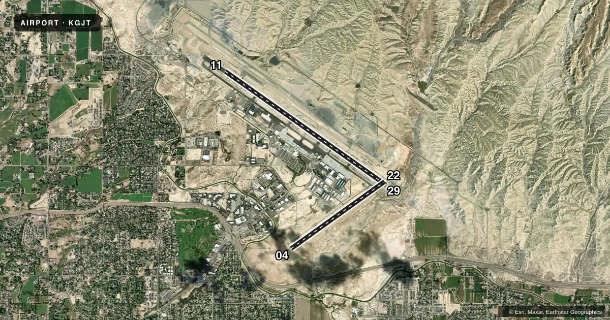
LEFT TRAFFIC| Runway | Heading (°M) | Length | Surface | Traffic |
|---|---|---|---|---|
| 11/29Favored | 116° / 296° | 9,339 ft | ASPH | Standard L |
| 04/22 | 45° / 225° | 5,501 ft | ASPH | Standard L |
Runway end performance
| End | TORA | TODA | ASDA | LDA | VGSI | Approach lights | Obstruction |
|---|---|---|---|---|---|---|---|
| 11 | 9,339' | 9,339' | 9,339' | 9,339' | PAPI 4-box left(3°) | MALSF | — |
| 29 | 9,339' | 9,339' | 9,339' | 9,339' | VASI 4-box left(3°) | — | — |
| 04 | 5,501' | 5,501' | 5,501' | 5,501' | PAPI 4-box left(3°) | — | — |
| 22 | 5,501' | 5,501' | 5,501' | 5,501' | — | — | — |
Declared distances in feet. TORA = takeoff run available, TODA = takeoff distance, ASDA = accelerate-stop, LDA = landing distance.
Airport sketch
Runways drawn to scale from FAA survey coordinates, rendered over satellite imagery. Not for navigation.
Approaches & charts
ILS · 2
Services on the field
Fuel grades, oxygen, maintenance, ramp storage and lighting — as declared to the FAA by the airport operator.
Fuel & services
- Fuel
- 100LLA
- Oxygen (bottled)
- High pressure
- Oxygen (bulk)
- High pressure
- Airframe repair
- Major
- Power plant repair
- Major
- Other services
- AFRT,AMB,AVNCS,CARGO,CHTR,INSTR,RNTL,SALES
Ramp & ground
- Transient storage
- Tie-down
- Hangar
- Landing fee
- No fee published
- Customs
- Not available
- Lighting schedule
- SEE RMK
- Beacon schedule
- SS-SR
- Beacon
- White / Green (civil land)(WG)
- Wind indicator
- Lighted
- Segmented circle
- Yes
Fuel & FBOs
Cheapest 100LL and Jet A on the field and nearby. Always confirm with the FBO before taxi.
Airport notes
Surface conditions, obstructions, local procedures, lighting outages and other notes published with each FAA cycle.
General notes
- TWY C1A & TWY C, 150 FT EITHER SIDE OF THE INTXN NOT VSBL FM ATCT.
- HEL PRKG AVBL AT FBO; PPR RCMDD.
- FLOCKS OF BIRDS ON & INVOF ARPT.
- NOISE ABATEMENT PROCEDURES IN EFCT, CTC ARPT MGMT FOR DETAILS AT (970) 244-9100.
- JASU: 1(MD-3A), 1(NC-10A/A1/BC), 2(AM32A-60B).
- FLUID: SP, LHOX LOX, LHNIT, DE-ICE(MIL A-8243).
- ARPT OPS NUMBER IS 970-260-7164. PLEASE CALL FOR ANY NOTAMS OR CONCERNS.
- CONDITIONS NOT MONITORED 0000-0530 LOCAL TIME EXCEPT BY PPR.
- CD FONE: WHEN TWR CLSD, CTC GRAND JUNCTION APCH 303-342-1916. IFUN, CTC DENVER ARTCC 303-342-4257.
Lighting notes
- WHEN ATCT CLSD ACTVT MALSF RWY 11; HIRL RWY 11/29; TWY LGTS - CTAF. REIL RWY 29; PAPI RWY 11; VASI RWY 29 ON CONSLY. REIL RWY 04 & 22; PAPI RWY 04; MIRL RWY 04/22 ON CONSLY DURG ATCT OPER HRS AND OFF WHEN ATCT CLSD.
Runway surface & condition
- 04/22PCR VALUE: 99/F/D/X/T
- 11/29PCR VALUE: 560/F/D/X/T
- 04/22RWY 04/22 CLSD FM 2200-0600.
Other notes
- LIQUID OXY SVC AVBL.
- ARFF PRVDD ONLY DURING SCHEDULED PART 121 ACR OPNS EXCEPT BY PPR; CALL AMGR 970-244-9100.
- 1FOR FUEL AFT HRS CALL 970-243-7500.
VFR map & nearby airports
VFR sectional. Tap any ICAO chip to open that airport.
Key facts · KGJT
Answer card- ICAO
- KGJT
- Name
- GRAND JUNCTION RGNL
- Location
- GRAND JUNCTION, COLORADO
- Elevation
- 4,861.4 ft MSL
- Traffic pattern altitude
- 5,861.4 ft MSL (1,000 AGL)
- Control tower
- Towered · 0600-2200
- Total runways
- 2
- Longest runway
- 11/29 · 9,339 ft
- Published ILS approaches
- 2
- Published frequencies
- 8
- Magnetic variation
- 9°
- Current flight rules
- VFR
- Current wind
- 140° at 18 kt
- Favored runway now
- RWY 11
Grand Junction Rgnl sits in Grand Junction, Colorado. The field elevation is 4,861.4 ft MSL. It has two asphalt runways. The longest is runway 11/29 at 9,339 ft. Runway 04/22 is 5,501 ft. The tower is open daily from 0600 to 2200.
Two ILS approaches are published. They serve runway ends 11 and 29. Pattern altitude is not published in the facts, so use the standard 1,000 ft AGL for light piston traffic unless ATC or the current Chart Supplement says otherwise. West Star Aviation is on the field. It carries 100LL and Jet A Prist. The airport also notes liquid oxygen service, liquid nitrogen and de-ice fluid availability.
This is a busy high-desert airport with noise abatement procedures in effect. Check with airport management for the current details before you go. Birds are reported on and near the airport, so keep a sharp scan on departure and arrival. Runway 04/22 is closed from 2200 to 0600. When the tower is closed, lighting is still available on the published systems. Taxiway C1A and taxiway C are not visible from the tower near their intersection, so stay alert when taxiing there. If you need after-hours fuel, call ahead. If you need clearance delivery after the tower closes, contact Grand Junction Approach first.