METAR & TAF D17
D17 does not publish a METAR.
Showing the nearest reporting station: KAJZ (BLAKE FLD) · 4.4 NM away. Conditions at D17 may differ.
METAR · KAJZ
Observed 10:15Z
KAJZ 271015Z AUTO 00000KT 10SM CLR 19/16 A3019 RMK AO2 T01870160
- Wind
- 000° @ 0 kt
- Visibility
- 10 SM
- Temp / Dew
- 19°C / 16°C
- Altimeter
- 30.19 inHg
- Clouds
- CLR
- Density alt
- 6,345 ft
- Ceiling
- Unlimited
- Rules
- VFR
Airport info & contacts
Manager on record, flight service, ARTCC, attendance schedule and pattern altitude — published by the FAA and refreshed every 28 days.
Location
- From city
- 4 NM W
- VFR sectional
- DENVER
- ARTCC
- ZDV · DENVER
- NOTAM facility
- DEN (NOTAM-D)
Airport manager
- Name
- TOM THOENSEN
- Phone
- 303-829-1696
- Address
- 1193 HWY 50, SUITE 101, 1156 MUSTANG LANE, DELTA CO 81416
Flight service · Hours
- FSS DEN
- DENVER1-800-WX-BRIEF
- Attendance
- 0800-1700
Frequencies
Tap any row to copy the frequency to your clipboard.
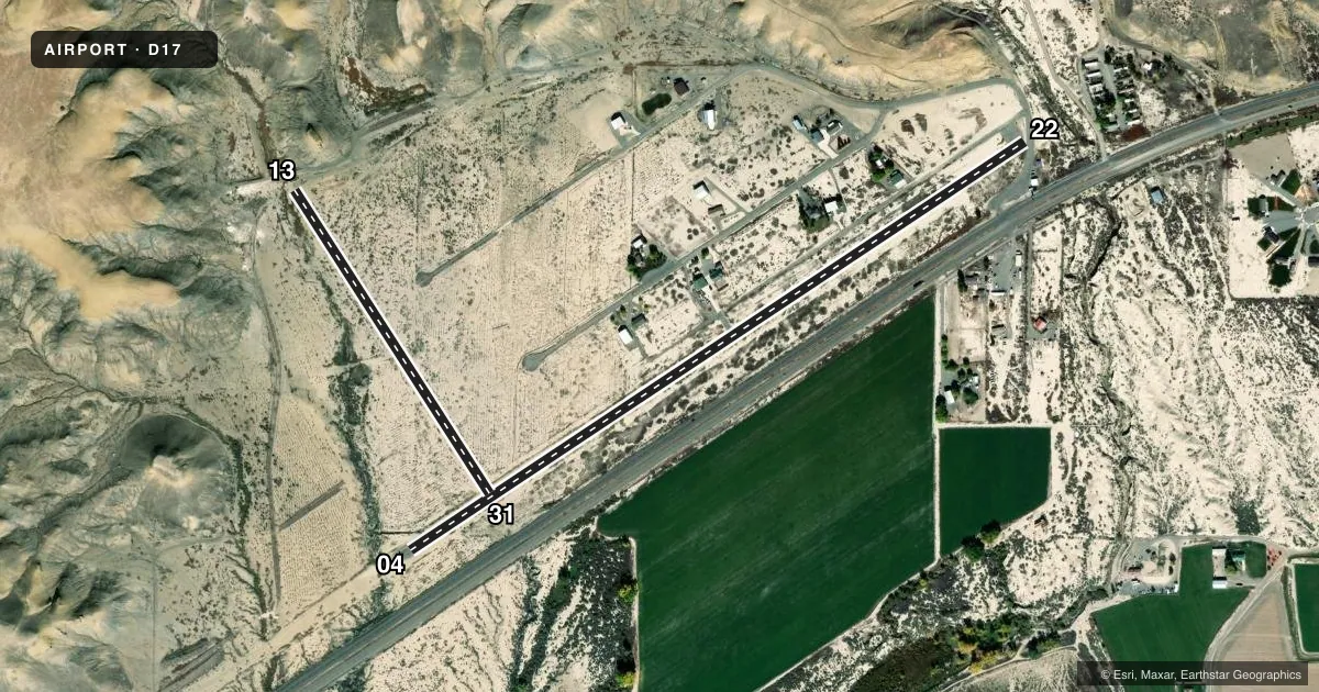
Runways & pattern
Full pagePattern entry · RWY 04
LEFT TRAFFIC| Runway | Heading (°M) | Length | Surface | Traffic |
|---|---|---|---|---|
| 04/22 | 44° / 224° | 4,100 ft | ASPH | Standard L |
| 13/31 | 135° / 315° | 2,000 ft | GRVL-DIRT | Standard L |
Runway end performance
| End | TORA | TODA | ASDA | LDA | VGSI | Approach lights | Obstruction |
|---|---|---|---|---|---|---|---|
| 22 | — | — | — | — | — | — | 70', trees, 505' from thr, 135' R of cntrln, slope 4 |
| 13 | — | — | — | — | — | — | 12', hill, 110' from thr, 0' R of cntrln, slope 9 |
| 31 | — | — | — | — | — | — | 15', road, 225' from thr, 0' R of cntrln, slope 15 |
Declared distances in feet. TORA = takeoff run available, TODA = takeoff distance, ASDA = accelerate-stop, LDA = landing distance.
Airport sketch
Runways drawn to scale from FAA survey coordinates, rendered over satellite imagery. Not for navigation.
Approaches & charts
Services on the field
Fuel grades, oxygen, maintenance, ramp storage and lighting — as declared to the FAA by the airport operator.
Fuel & services
- Fuel
- Not available
- Other services
- GLD,INSTR
Ramp & ground
- Transient storage
- Tie-down
- Wind indicator
- Yes
- Segmented circle
- No
Fuel & FBOs
Cheapest 100LL and Jet A on the field and nearby. Always confirm with the FBO before taxi.
Airport notes
Surface conditions, obstructions, local procedures, lighting outages and other notes published with each FAA cycle.
General notes
- +100 TO 300 FT MOUNTAINS LCTD NORTH; WEST & EAST OF ARPT AT VARYING DISTANCES.
- RY 22 HAS 180 FT MOUNTAIN 1500 FT FROM RY END, APPCH SLOPE 7:1.
- RY 4 HAS +120 FT TERRAIN 2700 FT FM THLD 380 FT L OF CNTRLN.
- RY 13/31 SOFT WHEN WET.
- RY 31 HAS +10 FT TREES 150 FT FM THLD OB; +40 FT TREE 600 FT FM THLD 50 FT R OF CNTRLN.
- FOR CD CTC DENVER ARTCC AT 303-651-4257.
- WILDLIFE ON AND INVOF ARPT.
Runway surface & condition
- 04/22CLSD TO ACFT 8,500 LBS OR MORE.
- 13/31RY END COORDINATES: RY 13: 38 45 37.77 N 108 09 15.96 W RY 31: 38 45 22.28 N 108 09 03.23 W
Approach & departure obstructions
- 04HAS +10 FT TREES 25 FT LEFT OF RY AT THLD.
- 2210 FT ROAD 100 FT FM THLD ON BOTH SIDES; 15 FT SHED 150 FT FM THLD 60 FT LEFT OF CNTRLN.
- 13RY 13 END CORRDINATES: 38 45 37.8 N 108 09 16.0 S
- 31RY 31 END COORDINATES: 38 45 22.3 N 108 09 03.2 S
VFR map & nearby airports
VFR sectional. Tap any ICAO chip to open that airport.
Key facts · D17
Answer card- ICAO
- D17
- Name
- WESTWINDS
- Location
- DELTA, COLORADO
- Elevation
- 5,000 ft MSL
- Traffic pattern altitude
- 6,000 ft MSL (1,000 AGL)
- Control tower
- Non-towered (use CTAF)
- Total runways
- 2
- Longest runway
- 04/22 · 4,100 ft
- Published ILS approaches
- 0
- Published frequencies
- 2
- Magnetic variation
- 12°
- Current flight rules
- VFR
- Current wind
- 000° at 0 kt
- Favored runway now
- –
Westwinds (D17) sits in Delta, Colorado at 5,000 ft MSL. It has two runways. The longest is 4,100 ft on 04/22. The airport is non-towered. CTAF and UNICOM are both 122.8. No ILS approaches are published.
Pattern altitude is not published. For a light piston, use the standard 1,000 ft AGL pattern unless the current Chart Supplement says otherwise. That puts the pattern at 6,000 ft MSL here. The field sits in mountain country. Terrain rises around the airport. Mountains ranging from 100 to 300 ft are reported north, west and east of the field at varying distances.
Runway 04/22 is asphalt. Runway 13/31 is 2,000 ft of gravel and dirt. Runway 04/22 is closed to aircraft 8,500 lb or more. Runway 13 and Runway 31 are soft when wet. Wildlife is reported on and near the airport. Runway 31 also has tree obstructions near the threshold. Runway 04 has trees left of the threshold. Runway 22 has a road near the threshold on both sides plus a shed left of centerline farther out.
No on-field FBOs are listed. Check with the airport operator or the FBO directly by phone for current services. For clearance delivery, contact Denver ARTCC at 303-651-4257.