METAR & TAF 7V2
7V2 does not publish a METAR.
Showing the nearest reporting station: KAJZ (BLAKE FLD) · 19.7 NM away. Conditions at 7V2 may differ.
METAR · KAJZ
Observed 10:15Z
KAJZ 271015Z AUTO 00000KT 10SM CLR 19/16 A3019 RMK AO2 T01870160
- Wind
- 000° @ 0 kt
- Visibility
- 10 SM
- Temp / Dew
- 19°C / 16°C
- Altimeter
- 30.19 inHg
- Clouds
- CLR
- Density alt
- 7,322 ft
- Ceiling
- Unlimited
- Rules
- VFR
Airport info & contacts
Manager on record, flight service, ARTCC, attendance schedule and pattern altitude — published by the FAA and refreshed every 28 days.
Location
- From city
- 3 NM SW
- VFR sectional
- DENVER
- Pattern altitude
- 800 ft AGL · 6,588 ft MSL
- ARTCC
- ZDV · DENVER
- NOTAM facility
- DEN (NOTAM-D)
Airport manager
- Name
- MIKE CLAWSON
- Phone
- 970-527-3345
- Address
- 38506 BACK RIVER RD, PAONIA CO 81428
Flight service · Hours
- FSS DEN
- DENVER1-800-WX-BRIEF
- Attendance
- MON-FRI · 0800-1800
- SAT-SUN · IREG
Frequencies
Tap any row to copy the frequency to your clipboard.
Runways & pattern
Full pagePattern entry · RWY 06
LEFT TRAFFICRunway end performance
| End | TORA | TODA | ASDA | LDA | VGSI | Approach lights | Obstruction |
|---|---|---|---|---|---|---|---|
| 06 | — | — | — | — | PAPI 2-box left | — | — |
| 24 | — | — | — | — | PAPI 2-box left | — | — |
Declared distances in feet. TORA = takeoff run available, TODA = takeoff distance, ASDA = accelerate-stop, LDA = landing distance.
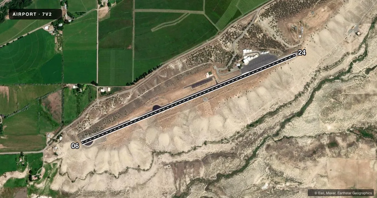
Airport sketch
Runways drawn to scale from FAA survey coordinates, rendered over satellite imagery. Not for navigation.
Approaches & charts
Services on the field
Fuel grades, oxygen, maintenance, ramp storage and lighting — as declared to the FAA by the airport operator.
Fuel & services
- Fuel
- 100LL
- Airframe repair
- Major
- Power plant repair
- Major
- Other services
- INSTR
Ramp & ground
- Transient storage
- Tie-down
- Hangar
- Landing fee
- No fee published
- Customs
- Not available
- Lighting schedule
- SEE RMK
- Wind indicator
- Lighted
- Segmented circle
- No
Fuel & FBOs
Cheapest 100LL and Jet A on the field and nearby. Always confirm with the FBO before taxi.
Airport notes
Surface conditions, obstructions, local procedures, lighting outages and other notes published with each FAA cycle.
General notes
- FOR CD CTC DENVER ARTCC AT 303-651-4257.
- LCL WX - CTAF; 4 CLICKS.
Lighting notes
- ACTVT PAPI RWY 06 & 24; MIRL RWY 06/24 - CTAF.
Fuel notes
- 100LLSELF SERVE H24.
Other notes
- MANAGER970-260-2138
VFR map & nearby airports
VFR sectional. Tap any ICAO chip to open that airport.
Key facts · 7V2
Answer card- ICAO
- 7V2
- Name
- NORTH FORK VALLEY
- Location
- PAONIA, COLORADO
- Elevation
- 5,788 ft MSL
- Traffic pattern altitude
- 6,588 ft MSL (800 AGL)
- Control tower
- Non-towered (use CTAF)
- Total runways
- 1
- Longest runway
- 06/24 · 4,500 ft
- Published ILS approaches
- 0
- Published frequencies
- 2
- Magnetic variation
- 13°
- Current flight rules
- VFR
- Current wind
- 000° at 0 kt
- Favored runway now
- –
North Fork Valley Airport sits in Paonia, Colorado. Field elevation is 5,788 ft MSL. The airport has one runway, 06/24, which is 4,500 ft long and asphalt. There is no control tower. CTAF and UNICOM are both 122.7. Pattern altitude is 800 ft AGL. That is 6,588 ft MSL.
No ILS approaches are published here. Local weather information is available on the CTAF frequency with four clicks. PAPI lighting is available for runways 06 and 24. Medium intensity runway lights are also activated on 06 and 24 on the CTAF frequency. Self-serve 100LL is available 24 hours a day. North Fork Aviation is on the field. It carries AVGAS 100LL.
This is a high-elevation airport, so performance planning matters. Expect thinner air and longer takeoff rolls than you would see at lower fields. For clearance delivery, contact Denver ARTCC at 303-651-4257. The airport manager can be reached at 970-260-2138. If you are new to the field, verify current weather, lighting use and any operational notes before you go.