METAR & TAF KMTJ
Current METAR
Observed 09:53Z
KMTJ 270953Z AUTO 14010KT 10SM CLR 19/15 A3022 RMK AO2 SLP132 T01940150
- Wind
- 140° @ 10 kt
- Visibility
- 10 SM
- Temp / Dew
- 19°C / 15°C
- Altimeter
- 30.22 inHg
- Clouds
- CLR
- Density alt
- 7,249 ft
- Ceiling
- Unlimited
- Rules
- VFR
Airport info & contacts
Manager on record, flight service, ARTCC, attendance schedule and pattern altitude — published by the FAA and refreshed every 28 days.
Location
- From city
- 1 NM NW
- VFR sectional
- DENVER
- ARTCC
- ZDV · DENVER
- NOTAM facility
- MTJ (NOTAM-D)
Airport manager
- Name
- LLOYD ARNOLD
- Phone
- 970-249-3433
- Address
- 2100 AIRPORT ROAD, MONTROSE CO 81401
Flight service · Hours
- FSS DEN
- DENVER1-800-WX-BRIEF
- Attendance
- APR1-DEC15 · 0530-2100
- DEC16-MAR31 · 0500-2100
Frequencies
Tap any row to copy the frequency to your clipboard.
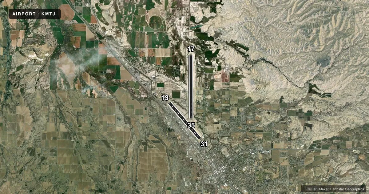
Runways & pattern
Full pagePattern entry · RWY 13
LEFT TRAFFIC| Runway | Heading (°M) | Length | Surface | Traffic |
|---|---|---|---|---|
| 17/35 | 168° / 348° | 10,000 ft | ASPH | Standard L |
| 13/31Favored | 127° / 307° | 7,510 ft | ASPH | Standard L |
Runway end performance
| End | TORA | TODA | ASDA | LDA | VGSI | Approach lights | Obstruction |
|---|---|---|---|---|---|---|---|
| 17 | 10,000' | 10,000' | 10,000' | 10,000' | PAPI 4-box left(3°) | MALSR | — |
| 35 | 10,000' | 10,000' | 10,000' | 10,000' | PAPI 4-box left(3°) | — | — |
| 13 | 7,510' | 7,510' | 7,510' | 7,510' | VASI 4-box left(3°) | — | 41', tree, 2050' from thr, 575' R of cntrln, slope 45 |
| 31 | 7,510' | 7,510' | 7,510' | 7,510' | VASI 4-box left(3°) | — | — |
Declared distances in feet. TORA = takeoff run available, TODA = takeoff distance, ASDA = accelerate-stop, LDA = landing distance.
Airport sketch
Runways drawn to scale from FAA survey coordinates, rendered over satellite imagery. Not for navigation.
Approaches & charts
ILS · 1
Services on the field
Fuel grades, oxygen, maintenance, ramp storage and lighting — as declared to the FAA by the airport operator.
Fuel & services
- Fuel
- 100LLA+
- Oxygen (bottled)
- High pressure
- Oxygen (bulk)
- High pressure
- Airframe repair
- Major
- Power plant repair
- Major
- Other services
- AMB,INSTR,RNTL
Ramp & ground
- Transient storage
- Tie-down
- Hangar
- Landing fee
- No fee published
- Customs
- Not available
- Lighting schedule
- SEE RMK
- Beacon schedule
- SS-SR
- Beacon
- White / Green (civil land)(WG)
- Wind indicator
- Lighted
- Segmented circle
- Yes
Fuel & FBOs
Cheapest 100LL and Jet A on the field and nearby. Always confirm with the FBO before taxi.
Airport notes
Surface conditions, obstructions, local procedures, lighting outages and other notes published with each FAA cycle.
General notes
- BIRDS & WILDLIFE ON & INVOF ARPT.
- ACR ACES TRML RAMP VIA TWY C; OUBD TFC TWY D.
- RAMP CNCTR ADJ TO T HNGR ROW CLSD INDEF; TWY E & E6 CLSD EXC WINGSPAN LESS THAN 78 FT.
- TWY B LTD TO SNGL WHEEL MAX 80000 LB; DBL WHEEL MAX 105000 LB; DBL TAND WHEEL MAX 170000 LB.
- FOR CD, IFUN TO CTC ON DENVER ARTCC APP/DEP CTL FREQ, CTC DENVER ARTCC AT 303-651-4257.
Lighting notes
- ACTVT MALSR RWY 17; REIL RWY 31 & 35; HIRL RWY 13/31 & 17/35 - CTAF.
Runway surface & condition
- 13/31PCR VALUE: 290/F/D/X/T
- 17/35PCR VALUE: 770/F/D/X/T
- 13/31RCMDD FOR APCH SPD LESS THAN 121 KT.
- 17/35RCMDD FOR APCH SPD MORE THAN 121 KT.
Approach & departure obstructions
- 13PREFERRED LNDG RWY.
- 17PREFERRED LNDG RWY.
- 31PREFERRED TKOF RWY.
- 35PREFERRED TKOF RWY.
- 13THREE MKD & LGTD POLES 1.5 MI NW RWY END.
Other notes
- UNSKED ACR OPS MORE THAN 30 PAX SEATS 24 HR PPR - AMGR.
- MANAGER970-249-3203 EXT 5811.
VFR map & nearby airports
VFR sectional. Tap any ICAO chip to open that airport.
Key facts · KMTJ
Answer card- ICAO
- KMTJ
- Name
- MONTROSE RGNL
- Location
- MONTROSE, COLORADO
- Elevation
- 5,758.5 ft MSL
- Traffic pattern altitude
- 6,758.5 ft MSL (1,000 AGL)
- Control tower
- Non-towered (use CTAF)
- Total runways
- 2
- Longest runway
- 17/35 · 10,000 ft
- Published ILS approaches
- 1
- Published frequencies
- 2
- Magnetic variation
- 12°
- Current flight rules
- VFR
- Current wind
- 140° at 10 kt
- Favored runway now
- RWY 13
Montrose Rgnl is in Montrose, Colorado. The field elevation is 5,758.5 ft MSL. It has two asphalt runways. The longest is runway 17/35 at 10,000 ft. There is no control tower, so expect CTAF and UNICOM self-announce traffic on 122.8.
An ILS is available to runway 17. Pattern altitude is not published, so use the standard 1,000 ft AGL for light piston operations unless the current Chart Supplement says otherwise. Atlantic Aviation is on the field. It carries 100LL and Jet A. Call ahead if you need current ramp or service details.
This is a high-elevation airport, so performance planning matters. Density altitude can climb fast in warm weather. Wildlife is also present on and near the airport, so keep a sharp scan on taxi, takeoff and landing. The published remarks also note that aircraft access to the terminal ramp is via taxiway C. Outbound traffic uses taxiway D. Runway 17 is the preferred landing runway. Runway 35 is the preferred takeoff runway. Large aircraft with more than 30 passenger seats need 24-hour prior permission from the airport manager.