METAR & TAF KAIB
Current METAR
Observed 07:55Z
KAIB 270755Z AUTO 05003KT 10SM CLR 19/18 A3021 RMK AO2 T01860176
- Wind
- 050° @ 3 kt
- Visibility
- 10 SM
- Temp / Dew
- 19°C / 18°C
- Altimeter
- 30.21 inHg
- Clouds
- CLR
- Density alt
- 7,492 ft
- Ceiling
- Unlimited
- Rules
- VFR
Airport info & contacts
Manager on record, flight service, ARTCC, attendance schedule and pattern altitude — published by the FAA and refreshed every 28 days.
Location
- From city
- 2 NM SW
- VFR sectional
- DENVER
- ARTCC
- ZDV · DENVER
- NOTAM facility
- DEN (NOTAM-D)
Airport manager
- Name
- LLOYD ARNOLD
- Phone
- 970-864-7111
- Address
- BOX 58, NUCLA CO 81424
Flight service · Hours
- FSS DEN
- DENVER1-800-WX-BRIEF
- Attendance
- Unattended
Frequencies
Tap any row to copy the frequency to your clipboard.
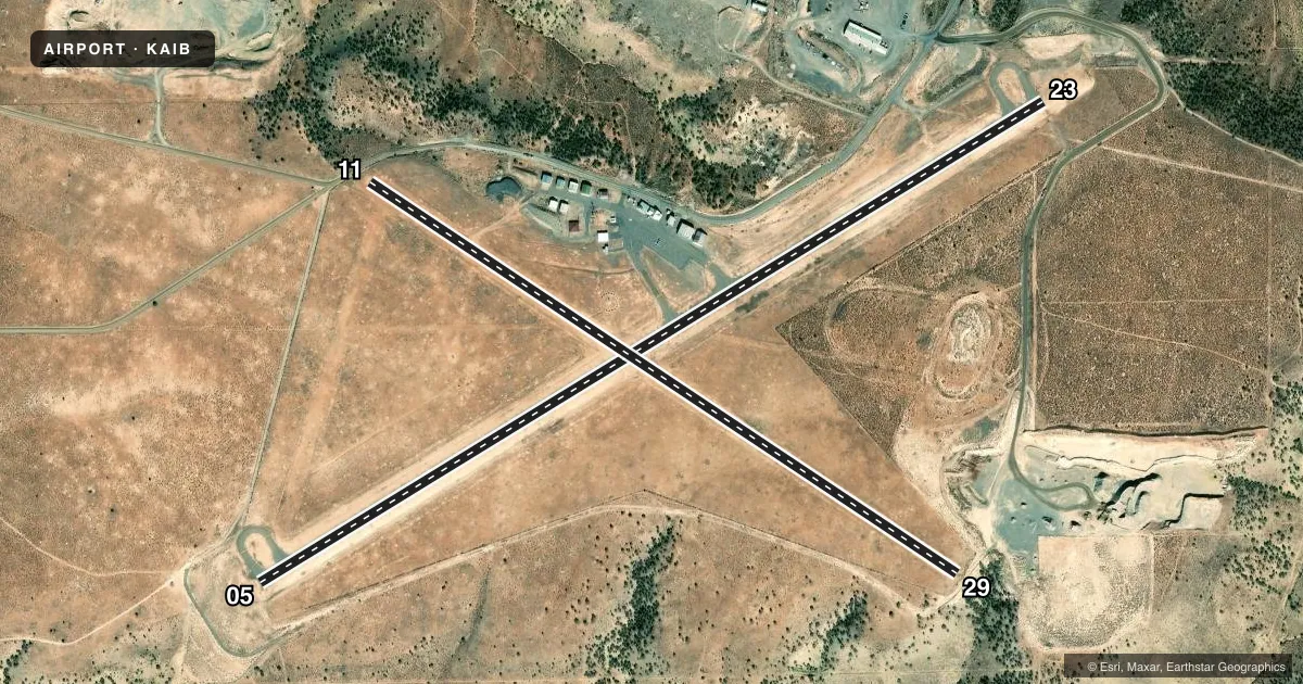
Runways & pattern
Full pagePattern entry · RWY 05
LEFT TRAFFIC| Runway | Heading (°M) | Length | Surface | Traffic |
|---|---|---|---|---|
| 05/23Favored | 48° / 228° | 5,212 ft | ASPH | Standard L |
| 11/29 | 113° / 293° | 4,000 ft | TURF-DIRT | Standard L |
Runway end performance
| End | TORA | TODA | ASDA | LDA | VGSI | Approach lights | Obstruction |
|---|---|---|---|---|---|---|---|
| 05 | — | — | — | — | PAPI 2-box left(3°) | — | — |
| 23 | — | — | — | — | PAPI 2-box left(3°) | — | 18', road, 570' from thr, 0' R of cntrln, slope 20 |
| 11 | — | — | — | — | — | — | 6', road, 100' from thr, 0' R of cntrln, slope 16 |
| 29 | — | — | — | — | — | — | 3', fence, 56' from thr, 0' R of cntrln, slope 18 |
Declared distances in feet. TORA = takeoff run available, TODA = takeoff distance, ASDA = accelerate-stop, LDA = landing distance.
Airport sketch
Runways drawn to scale from FAA survey coordinates, rendered over satellite imagery. Not for navigation.
Approaches & charts
Services on the field
Fuel grades, oxygen, maintenance, ramp storage and lighting — as declared to the FAA by the airport operator.
Fuel & services
- Fuel
- 100LLA
- Oxygen (bottled)
- Not available
- Oxygen (bulk)
- Not available
Ramp & ground
- Transient storage
- Tie-down
- Landing fee
- No fee published
- Customs
- Not available
- Lighting schedule
- SEE RMK
- Beacon schedule
- SS-SR
- Beacon
- White / Green (civil land)(WG)
- Wind indicator
- Lighted
- Segmented circle
- Yes
Fuel & FBOs
Cheapest 100LL and Jet A on the field and nearby. Always confirm with the FBO before taxi.
Airport notes
Surface conditions, obstructions, local procedures, lighting outages and other notes published with each FAA cycle.
General notes
- 40 FT PLINES IN HANGAR AREA.
- MIGTATORY BIRDS, WILDLIFE & DEER ON OR INVOF ARPT.
- FOR CD CTC DENVER ARTCC AT 303-651-4257.
Lighting notes
- REIL RWY 05 & 23; MIRL RWY 5/23 - DUSK-DAWN, INCR INTST - CTAF. PAPI RWY 05 & 23 ON CONSLY.
Fuel notes
- 100LLFUEL SELF-SERVICE AVBL 24 HRS.
Approach & departure obstructions
- 05PAPI UNUSBL BYD 5.0 NM.
Other notes
- 11/29MULT LRG RODENT HOLES.
VFR map & nearby airports
VFR sectional. Tap any ICAO chip to open that airport.
Key facts · KAIB
Answer card- ICAO
- KAIB
- Name
- HOPKINS FLD
- Location
- NUCLA, COLORADO
- Elevation
- 5,945.1 ft MSL
- Traffic pattern altitude
- 6,945.1 ft MSL (1,000 AGL)
- Control tower
- Non-towered (use CTAF)
- Total runways
- 2
- Longest runway
- 05/23 · 5,212 ft
- Published ILS approaches
- 0
- Published frequencies
- 2
- Magnetic variation
- 11°
- Current flight rules
- VFR
- Current wind
- 050° at 3 kt
- Favored runway now
- RWY 05
Hopkins Field sits in Nucla, Colorado at 5,945.1 ft MSL. It has two runways. The longest is runway 05/23 at 5,212 ft asphalt. Runway 11/29 is 4,000 ft turf-dirt. There is no control tower. CTAF and UNICOM are both 122.8.
No ILS approaches are published here. The published pattern altitude is not listed. Use standard 1,000 ft AGL for light piston traffic unless the current Chart Supplement says otherwise. Hopkins Field has one on-field FBO, Hopkins Field. It carries 100LL and Jet A. Self-serve 100LL is available 24 hours.
The field has a few items that matter on a first visit. There are 40-foot power lines in the hangar area. Wildlife is a known issue. Migratory birds, deer and other animals have been reported on or near the airport. Runway 11/29 also has multiple large rodent holes. Runway 05 has a PAPI, but it is unusable beyond 5 NM. Runways 05 and 23 have runway end identifier lights. They also have medium intensity runway lights from dusk to dawn.
This is a high-elevation airport. Expect density altitude to matter, especially on warm days. Check the current Chart Supplement for any published noise or curfew restrictions before flying into the field. For clearance delivery, contact Denver ARTCC at 303-651-4257.