METAR & TAF U64
Current METAR
Observed 06:15Z
KU64 270615Z AUTO 26006KT 10SM BKN140 17/14 A3035 RMK AO2 T01690144 $
- Wind
- 260° @ 6 kt
- Visibility
- 10 SM
- Temp / Dew
- 17°C / 14°C
- Altimeter
- 30.35 inHg
- Clouds
- BKN
- Density alt
- 8,349 ft
- Ceiling
- 14,000 ft AGL
- Rules
- VFR
Airport info & contacts
Manager on record, flight service, ARTCC, attendance schedule and pattern altitude — published by the FAA and refreshed every 28 days.
Location
- From city
- 3 NM N
- VFR sectional
- DENVER
- ARTCC
- ZDV · DENVER
- NOTAM facility
- CDC (NOTAM-D)
Airport manager
- Name
- KAEDEN KULOW
- Phone
- 435-587-2271
- Address
- PO BOX 457, MONTICELLO UT 84535
Flight service · Hours
- FSS CDC
- CEDAR CITY1-800-WX-BRIEF
- Attendance
- Unattended
Frequencies
Tap any row to copy the frequency to your clipboard.
Runways & pattern
Full pagePattern entry · RWY 16
LEFT TRAFFICRunway end performance
| End | TORA | TODA | ASDA | LDA | VGSI | Approach lights | Obstruction |
|---|---|---|---|---|---|---|---|
| 16 | — | — | — | — | PAPI 2-box left(3°) | — | — |
| 34 | — | — | — | — | PAPI 2-box left(3°) | — | — |
Declared distances in feet. TORA = takeoff run available, TODA = takeoff distance, ASDA = accelerate-stop, LDA = landing distance.
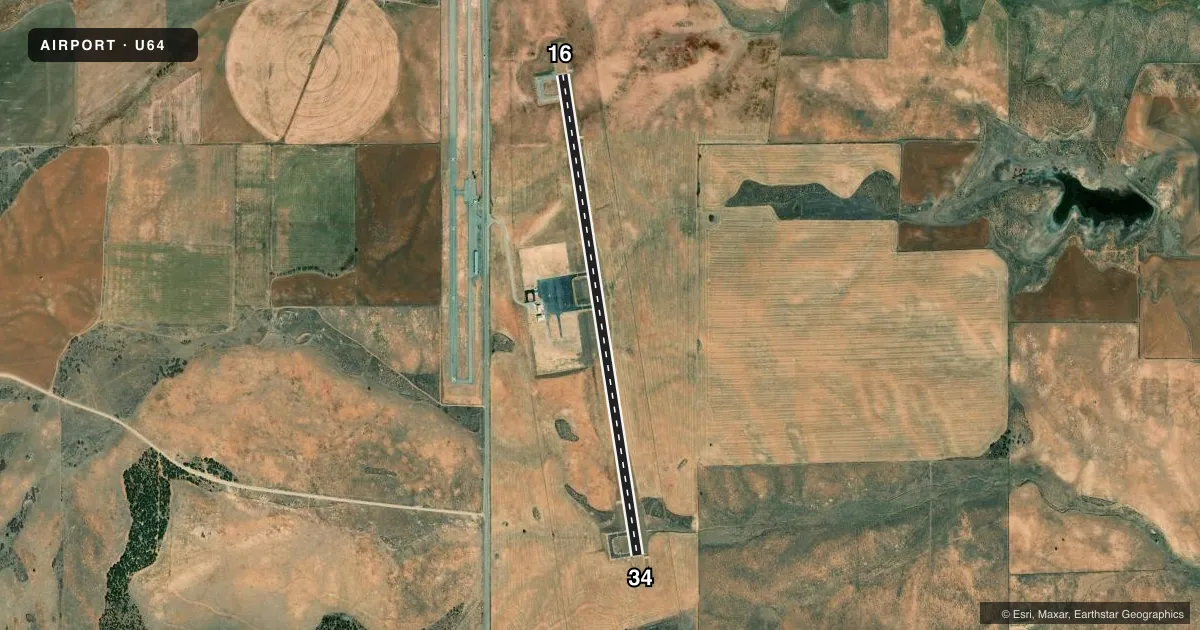
Airport sketch
Runways drawn to scale from FAA survey coordinates, rendered over satellite imagery. Not for navigation.
Approaches & charts
Services on the field
Fuel grades, oxygen, maintenance, ramp storage and lighting — as declared to the FAA by the airport operator.
Fuel & services
- Fuel
- 100LLA
- Oxygen (bottled)
- Not available
- Oxygen (bulk)
- Not available
- Airframe repair
- Not available
- Power plant repair
- Not available
Ramp & ground
- Transient storage
- Tie-down
- Landing fee
- No fee published
- Lighting schedule
- SEE RMK
- Beacon schedule
- SS-SR
- Beacon
- White / Green (civil land)(WG)
- Wind indicator
- Lighted
- Segmented circle
- Yes
Fuel & FBOs
Cheapest 100LL and Jet A on the field and nearby. Always confirm with the FBO before taxi.
Airport notes
Surface conditions, obstructions, local procedures, lighting outages and other notes published with each FAA cycle.
General notes
- FOR CD CTC DENVER ARTCC AT 303-651-4257.
- ACFT NOT VSB FM OPPOSITE END OF RWY.
Lighting notes
- ACTVT REIL RWY 16 & 34; PAPI RWY 16 & 34; MIRL RWY 16/34 - CTAF.
Fuel notes
- A24 HR SELF SVC.
Approach & departure obstructions
- 164 FT MOUND, 40 FT FM RWY, 120 FT LEFT.
- 343 FT MOUND, 40 FT FM RWY END, 120 FT RIGHT.
- 16PAINT FADING
- 34PAINT FADING
Other notes
- MANAGERCITY/ARPT MGR.
- MANAGEREXT 13.
- 16/34EXTSV CRACKING WITH LOOSE STONES.
VFR map & nearby airports
VFR sectional. Tap any ICAO chip to open that airport.
Key facts · U64
Answer card- ICAO
- U64
- Name
- MONTICELLO
- Location
- MONTICELLO, UTAH
- Elevation
- 6,969.9 ft MSL
- Traffic pattern altitude
- 7,969.9 ft MSL (1,000 AGL)
- Control tower
- Non-towered (use CTAF)
- Total runways
- 1
- Longest runway
- 16/34 · 5,998 ft
- Published ILS approaches
- 0
- Published frequencies
- 2
- Magnetic variation
- 9°
- Current flight rules
- VFR
- Current wind
- 260° at 6 kt
- Favored runway now
- RWY 16
Monticello Airport sits in Monticello, Utah. Field elevation is 6,969.9 ft MSL. The airport has one runway, 16/34, which is 5,998 ft long. It is not towered. CTAF and UNICOM are both 122.8. No ILS approaches are published, so plan with the current chart and your own avionics setup.
The pattern altitude is not published. Use 1,000 ft AGL for light piston traffic unless the current Chart Supplement says otherwise. That puts the pattern at about 7,970 ft MSL. This is a high-elevation field, so expect performance to feel different than at lower airports. Density altitude can climb fast in warm weather.
Published remarks matter here. 24-hour self-serve avgas is available. Runway 16/34 has medium intensity lights, REILs and PAPI. The pavement also has extensive cracking with loose stones. There is a 4-foot mound near runway 16 on the left side. There is also a 3-foot mound near runway 34 on the right side. Paint is fading on both ends. Aircraft are not visible from the opposite end of the runway, so keep your scan sharp in the pattern and on rollout. For clearance delivery, contact Denver Air Route Traffic Control Center at 303-651-4257.