METAR & TAF 66V
66V does not publish a METAR.
Showing the nearest reporting station: KBDG (BLANDING MUNI) · 21.0 NM away. Conditions at 66V may differ.
METAR · KBDG
Observed 16:35Z
KBDG 261635Z AUTO 00000KT 10SM OVC140 27/12 A3028 RMK AO2 T02710118
- Wind
- 000° @ 0 kt
- Visibility
- 10 SM
- Temp / Dew
- 27°C / 12°C
- Altimeter
- 30.28 inHg
- Clouds
- OVC
- Density alt
- 6,544 ft
- Ceiling
- 14,000 ft AGL
- Rules
- VFR
Airport info & contacts
Manager on record, flight service, ARTCC, attendance schedule and pattern altitude — published by the FAA and refreshed every 28 days.
Location
- From city
- 4 NM SW
- VFR sectional
- DENVER
- ARTCC
- ZDV · DENVER
- NOTAM facility
- CDC (NOTAM-D)
Airport manager
- Name
- JIM HOOK
- Phone
- 435-672-2281
- Address
- PO BOX 324, BLUFF UT 84512
Flight service · Hours
- FSS CDC
- CEDAR CITY1-800-WX-BRIEF
- Attendance
- Unattended
Frequencies
Tap any row to copy the frequency to your clipboard.
Runways & pattern
Full pagePattern entry · RWY 03
LEFT TRAFFICRunway end performance
| End | TORA | TODA | ASDA | LDA | VGSI | Approach lights | Obstruction |
|---|---|---|---|---|---|---|---|
| 03 | — | — | — | — | — | — | 10', road, 201' from thr, 45' R of cntrln, slope 0 |
Declared distances in feet. TORA = takeoff run available, TODA = takeoff distance, ASDA = accelerate-stop, LDA = landing distance.
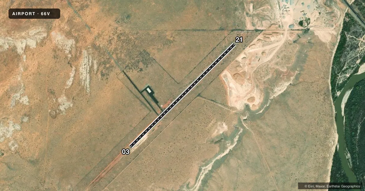
Airport sketch
Runways drawn to scale from FAA survey coordinates, rendered over satellite imagery. Not for navigation.
Approaches & charts
Services on the field
Fuel grades, oxygen, maintenance, ramp storage and lighting — as declared to the FAA by the airport operator.
Fuel & services
- Fuel
- Not available
- Oxygen (bottled)
- Not available
- Oxygen (bulk)
- Not available
- Airframe repair
- Not available
- Power plant repair
- Not available
Ramp & ground
- Transient storage
- Tie-down
- Landing fee
- No fee published
- Customs
- Not available
- Wind indicator
- Yes
- Segmented circle
- No
Fuel & FBOs
Cheapest 100LL and Jet A on the field and nearby. Always confirm with the FBO before taxi.
Airport notes
Surface conditions, obstructions, local procedures, lighting outages and other notes published with each FAA cycle.
General notes
- GRVL PIT 1/4 MILE OFF AER 21.
- FOR CD CTC DENVER ARTCC AT 303-651-4257.
Approach & departure obstructions
- 0320 FT DIRT RD PARALLEL TO RWY, 45 FT LEFT OF RWY CNTRLN.
- 03CTLG OBSTN EXCEEDS A 45 DEG SLOPE.
Other notes
- ESTABD PRIOR TO 1959.
- OWNERLEASED FROM THE BLM.
VFR map & nearby airports
VFR sectional. Tap any ICAO chip to open that airport.
Key facts · 66V
Answer card- ICAO
- 66V
- Name
- BLUFF
- Location
- BLUFF, UTAH
- Elevation
- 4,476 ft MSL
- Traffic pattern altitude
- 5,476 ft MSL (1,000 AGL)
- Control tower
- Non-towered (use CTAF)
- Total runways
- 1
- Longest runway
- 03/21 · 3,000 ft
- Published ILS approaches
- 0
- Published frequencies
- 1
- Magnetic variation
- 13°
- Current flight rules
- VFR
- Current wind
- 000° at 0 kt
- Favored runway now
- –
Bluff Airport (66V) sits in Bluff, Utah at 4,476 ft MSL. It has one runway, 03/21, which is 3,000 ft asphalt. The field is non-towered. CTAF is 122.9. No ILS approaches are published here.
Pattern altitude is not published. Use standard 1,000 ft AGL unless the current Chart Supplement or local procedure says otherwise. That puts the light-piston pattern at about 5,476 ft MSL. The airport is leased from the Bureau of Land Management. It was established before 1959.
There are a few things a first-time pilot should have in mind. A gravel pit sits about one quarter mile off the approach end of runway 21. There is also a cataloged obstruction at the runway 03 end that exceeds a 45 degree slope. A 20 foot dirt road runs parallel to the runway near the 03 end, about 45 feet left of centerline. Clearance delivery is handled through Denver ARTCC at 303-651-4257. No on-field FBOs are listed, so plan to verify services with the airport operator or the FBO directly by phone before you go. The elevation is high enough that density altitude can matter, especially in warm weather.