METAR & TAF KCEZ
Current METAR
Observed 03:53Z
KCEZ 270353Z AUTO 11003KT 10SM CLR 24/12 A3023 RMK AO2 SLP144 T02440117
- Wind
- 110° @ 3 kt
- Visibility
- 10 SM
- Temp / Dew
- 24°C / 12°C
- Altimeter
- 30.23 inHg
- Clouds
- CLR
- Density alt
- 8,033 ft
- Ceiling
- Unlimited
- Rules
- VFR
Airport info & contacts
Manager on record, flight service, ARTCC, attendance schedule and pattern altitude — published by the FAA and refreshed every 28 days.
Location
- From city
- 3 NM SW
- VFR sectional
- DENVER
- ARTCC
- ZDV · DENVER
- NOTAM facility
- CEZ (NOTAM-D)
Airport manager
- Name
- KYLE SLOAN
- Phone
- 970-570-2980
- Address
- 123 ROGER SMITH AVE., CORTEZ CO 81321
Flight service · Hours
- FSS DEN
- DENVER1-800-WX-BRIEF
- Attendance
- DAWN-DUSK
Frequencies
Tap any row to copy the frequency to your clipboard.
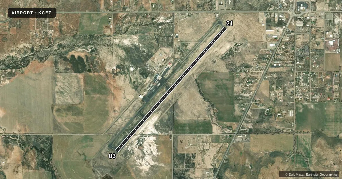
Runways & pattern
Full pagePattern entry · RWY 03
LEFT TRAFFICRunway end performance
| End | TORA | TODA | ASDA | LDA | VGSI | Approach lights | Obstruction |
|---|---|---|---|---|---|---|---|
| 03 | 7,205' | 7,205' | 7,205' | 7,205' | PAPI 4-box left(3°) | — | 59', trees, 2000' from thr, 350' R of cntrln, slope 30 |
| 21 | 7,205' | 7,205' | 7,205' | 7,205' | VASI 4-box left(3°) | — | 16', road, 680' from thr, 300' R of cntrln, slope 30 |
Declared distances in feet. TORA = takeoff run available, TODA = takeoff distance, ASDA = accelerate-stop, LDA = landing distance.
Airport sketch
Runways drawn to scale from FAA survey coordinates, rendered over satellite imagery. Not for navigation.
Approaches & charts
Services on the field
Fuel grades, oxygen, maintenance, ramp storage and lighting — as declared to the FAA by the airport operator.
Fuel & services
- Fuel
- 100LLA
- Oxygen (bulk)
- High pressure
- Airframe repair
- Major
- Power plant repair
- Major
- Other services
- CHTR,INSTR,RNTL,SALES
Ramp & ground
- Transient storage
- Tie-down
- Hangar
- Landing fee
- Yes
- Customs
- Not available
- Lighting schedule
- SEE RMK
- Beacon schedule
- SS-SR
- Beacon
- White / Green (civil land)(WG)
- Wind indicator
- Lighted
- Segmented circle
- Yes
Fuel & FBOs
Cheapest 100LL and Jet A on the field and nearby. Always confirm with the FBO before taxi.
Airport notes
Surface conditions, obstructions, local procedures, lighting outages and other notes published with each FAA cycle.
General notes
- ACFT GTR THAN 20000 LBS DUAL WHEEL RSTRD TO TWY CONNECTOR A2; BACK TAXI ON RWY TO & FM TWY CONNECTOR A2 TO APRON.
- FOR CD CTC DENVER ARTCC ON FREQ. IF UNA, CTC FSS ON FREQ VIA RCO. IF UNA, CTC DENVER ARTCC AT 303-651-4257.
Lighting notes
- ACTVT REIL RWY 03 & 21; MIRL RWY 03/21 - CTAF. PAPI RWY 03 & VASI RWY 21 ON CONSLY.
Approach & departure obstructions
- 03133 FT POLE ON CNTRLN.
Other notes
- PPR FOR UNSKED ACR OPS WITH MORE THAN 30 PAX SEATS - AMGR.
VFR map & nearby airports
VFR sectional. Tap any ICAO chip to open that airport.
Key facts · KCEZ
Answer card- ICAO
- KCEZ
- Name
- CORTEZ MUNI
- Location
- CORTEZ, COLORADO
- Elevation
- 5,917.6 ft MSL
- Traffic pattern altitude
- 6,917.6 ft MSL (1,000 AGL)
- Control tower
- Non-towered (use CTAF)
- Total runways
- 1
- Longest runway
- 03/21 · 7,205 ft
- Published ILS approaches
- 0
- Published frequencies
- 2
- Magnetic variation
- 12°
- Current flight rules
- VFR
- Current wind
- 110° at 3 kt
- Favored runway now
- RWY 03
Cortez Muni sits in Cortez, Colorado. The field elevation is 5,917.6 ft MSL. It has one runway, 03/21, which is 7,205 ft long. There is no control tower. CTAF and UNICOM are both 122.8.
No ILS approaches are published here. The pattern altitude is not published in the facts, so use the standard 1,000 ft AGL for light piston traffic unless the current Chart Supplement says otherwise. That puts you at about 6,918 ft MSL based on the listed field elevation. The runway lighting is pilot controlled on CTAF. Runway end identifier lights are on both ends. A PAPI is on runway 03. A VASI is on runway 21.
Cortez Flying Service is on the field. It carries 100LL and Jet A Prist. Call them at (970) 565-3721 for current service details. The published remarks also note a 133-foot pole on the centerline of runway 03. That is worth keeping in mind on departure and arrival. Aircraft over 20,000 pounds with dual wheels are limited to taxiway connector A2. They also need to back taxi on runway to and from A2 and the apron. For larger or unscheduled passenger operations, check with the airport manager before you go. This is a high-elevation airport, so expect density altitude to matter on warm days.