METAR & TAF KFMN
Current METAR
Observed 11:53Z
KFMN 271153Z AUTO 05003KT 10SM CLR 21/14 A3018 RMK AO2 SLP142 T02060139 10250 20206 55001 TSNO $
- Wind
- 050° @ 3 kt
- Visibility
- 10 SM
- Temp / Dew
- 21°C / 14°C
- Altimeter
- 30.18 inHg
- Clouds
- CLR
- Density alt
- 7,226 ft
- Ceiling
- Unlimited
- Rules
- VFR
Airport info & contacts
Manager on record, flight service, ARTCC, attendance schedule and pattern altitude — published by the FAA and refreshed every 28 days.
Location
- From city
- 1 NM NW
- VFR sectional
- DENVER
- ARTCC
- ZDV · DENVER
- NOTAM facility
- FMN (NOTAM-D)
Airport manager
- Name
- JEREMY PATTON
- Phone
- 505-599-1462
- Address
- 800 MUNICIPAL DR, FARMINGTON NM 87401-2663
Flight service · Hours
- FSS ABQ
- ALBUQUERQUE1-800-WX-BRIEF
- Attendance
- 0600-2200
Frequencies
Tap any row to copy the frequency to your clipboard.
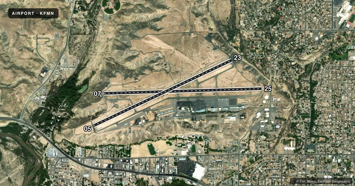
Runways & pattern
Full pagePattern entry · RWY 05
LEFT TRAFFIC| Runway | Heading (°M) | Length | Surface | Traffic |
|---|---|---|---|---|
| 07/25 | 76° / 256° | 6,704 ft | ASPH | Standard L |
| 05/23Favored | 53° / 233° | 6,501 ft | ASPH | Standard L |
Runway end performance
| End | TORA | TODA | ASDA | LDA | VGSI | Approach lights | Obstruction |
|---|---|---|---|---|---|---|---|
| 07 | 6,704' | 6,704' | 6,487' | 6,248' | VASI 4-box left(3°) | — | — |
| 25 | 6,704' | 6,704' | 6,465' | 6,248' | VASI 4-box left(3°) | — | — |
| 05 | 6,501' | 6,501' | 5,590' | 5,590' | PAPI 4-box left(3°) | — | — |
| 23 | 6,501' | 6,501' | 6,101' | 5,590' | PAPI 4-box right(3°) | — | — |
Declared distances in feet. TORA = takeoff run available, TODA = takeoff distance, ASDA = accelerate-stop, LDA = landing distance.
Airport sketch
Runways drawn to scale from FAA survey coordinates, rendered over satellite imagery. Not for navigation.
Approaches & charts
ILS · 1
Services on the field
Fuel grades, oxygen, maintenance, ramp storage and lighting — as declared to the FAA by the airport operator.
Fuel & services
- Fuel
- 100LLAA1+
- Oxygen (bottled)
- Low pressure
- Oxygen (bulk)
- Low pressure
- Airframe repair
- Major
- Power plant repair
- Major
- Other services
- AFRT,AMB,CARGO,CHTR,INSTR,RNTL,SALES
Ramp & ground
- Transient storage
- Tie-down
- Hangar
- Landing fee
- No fee published
- Customs
- Not available
- Lighting schedule
- SEE RMK
- Beacon schedule
- SS-SR
- Beacon
- White / Green (civil land)(WG)
- Wind indicator
- Lighted
- Segmented circle
- Yes
Fuel & FBOs
Cheapest 100LL and Jet A on the field and nearby. Always confirm with the FBO before taxi.
Airport notes
Surface conditions, obstructions, local procedures, lighting outages and other notes published with each FAA cycle.
General notes
- FOR CD CTC FARMINGTON ATCT GROUND CONTROL 121.7, WHEN ATCT CLSD CTC DENVER ARTCC AT 303-651-4257.
- ARPT SFC CONDS UNMON OUTSIDE OF ATNDD HRS.
Lighting notes
- WHEN ATCT CLSD ACTVT REIL RWY 23 & 25; PAPI RWY 05 & 23; VASI RWY 07 & 25; MIRL RWY 05/23 & 07/25 - CTAF. REIL RWY 25 & MIRL RWY 07/25 PRESET LOW INTST; INCR INTST - CTAF.
Runway surface & condition
- 05/23PCR VALUE: 100/F/D/X/T
- 07/25PCR VALUE: 250/F/D/X/T
VFR map & nearby airports
VFR sectional. Tap any ICAO chip to open that airport.
Key facts · KFMN
Answer card- ICAO
- KFMN
- Name
- FOUR CORNERS RGNL
- Location
- FARMINGTON, NEW MEXICO
- Elevation
- 5,506.6 ft MSL
- Traffic pattern altitude
- 6,506.6 ft MSL (1,000 AGL)
- Control tower
- Towered · 0600-2200
- Total runways
- 2
- Longest runway
- 07/25 · 6,704 ft
- Published ILS approaches
- 1
- Published frequencies
- 8
- Magnetic variation
- 12°
- Current flight rules
- VFR
- Current wind
- 050° at 3 kt
- Favored runway now
- RWY 05
Four Corners Rgnl sits in Farmington, New Mexico. Field elevation is 5,506.6 ft MSL. The airport has two asphalt runways. The longest is runway 07/25 at 6,704 ft. Runway 05/23 is 6,501 ft. The field is towered from 0600 to 2200. When the tower is closed, runway lighting is activated on CTAF. The published ILS is for runway 25.
Pattern altitude is not published. Use 1,000 ft AGL for light piston traffic unless the current Chart Supplement or tower gives you a different instruction. That puts you in the standard pattern for this field. The airport sits at high elevation. Expect performance to matter on warm days. Check density altitude before departure. Surface conditions are unmonitored outside attended hours.
Atlantic Aviation is on the field. It carries 100LL and Jet A. For clearance delivery, tower ground uses 121.7 when the tower is open. When the tower is closed, contact Denver ARTCC at 303-651-4257. If you are arriving after hours, verify lighting and any local procedures before you launch. The runway PCN values are published for both runways. That matters for heavier aircraft planning.