METAR & TAF N19
N19 does not publish a METAR.
Showing the nearest reporting station: KFMN (FOUR CORNERS RGNL) · 11.3 NM away. Conditions at N19 may differ.
METAR · KFMN
Observed 05:53Z
KFMN 270553Z AUTO 09005KT 10SM CLR 26/14 A3019 RMK AO2 SLP146 60000 T02560139 10367 20250 51008 TSNO $
- Wind
- 090° @ 5 kt
- Visibility
- 10 SM
- Temp / Dew
- 26°C / 14°C
- Altimeter
- 30.19 inHg
- Clouds
- CLR
- Density alt
- 8,279 ft
- Ceiling
- Unlimited
- Rules
- VFR
Airport info & contacts
Manager on record, flight service, ARTCC, attendance schedule and pattern altitude — published by the FAA and refreshed every 28 days.
Location
- From city
- 2 NM NW
- VFR sectional
- DENVER
- ARTCC
- ZDV · DENVER
- NOTAM facility
- ABQ (NOTAM-D)
Airport manager
- Name
- DIANNE LOPEZ
- Phone
- 505-334-7606
- Address
- 201 W. CHACO, AZTEC NM 87410
Flight service · Hours
- FSS ABQ
- ALBUQUERQUE1-800-WX-BRIEF
- Attendance
- Unattended
Frequencies
Tap any row to copy the frequency to your clipboard.
Runways & pattern
Full pagePattern entry · RWY 08
LEFT TRAFFICRunway end performance
| End | TORA | TODA | ASDA | LDA | VGSI | Approach lights | Obstruction |
|---|---|---|---|---|---|---|---|
| 08 | 4,314' | 4,314' | 4,037' | 3,811' | PNIL(3.5°) | — | — |
| 26 | 4,314' | 4,314' | 4,088' | 3,811' | PSIL(3°) | — | — |
Declared distances in feet. TORA = takeoff run available, TODA = takeoff distance, ASDA = accelerate-stop, LDA = landing distance.
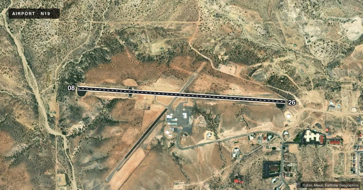
Airport sketch
Runways drawn to scale from FAA survey coordinates, rendered over satellite imagery. Not for navigation.
Approaches & charts
Services on the field
Fuel grades, oxygen, maintenance, ramp storage and lighting — as declared to the FAA by the airport operator.
Fuel & services
- Fuel
- 100LL
Ramp & ground
- Transient storage
- Tie-down
- Hangar
- Landing fee
- No fee published
- Customs
- Not available
- Lighting schedule
- SEE RMK
- Beacon schedule
- SS-SR
- Beacon
- White / Green (civil land)(WG)
- Wind indicator
- Lighted
- Segmented circle
- Yes
Fuel & FBOs
Cheapest 100LL and Jet A on the field and nearby. Always confirm with the FBO before taxi.
Airport notes
Surface conditions, obstructions, local procedures, lighting outages and other notes published with each FAA cycle.
General notes
- LCTD ATOP MESA.
- GATE ACES 1987#.
- FOR CD CTC DENVER ARTCC AT 303-651-4257.
- RUNUPS ON TURN AROUNDS NA.
Lighting notes
- ACTVT PLASI RWY 26; MIRL RWY 08/26 - CTAF. MIRL ON FM SS TO 2230 HRS AND FM 0400 TO SR.
Fuel notes
- 100LL24 HR 100 LL AVBL WITH MAJOR CREDIT CARD.
Runway surface & condition
- 08/264 FT FENCE 105 FT FM CNTRLN INTMT ALG RWY BOTH SIDES. 60-180 FT TRRN DROP OFF BYD RWY ENDS.
Approach & departure obstructions
- 084 FT BUSH 30 FT FM THLD ON CNTRLN.
- 263 FT FENCE POST 20 FT FM THLD, 70 FT LEFT OF CNTRLN.
- 26PREFERRED NGT OPS.
- 08APCH SLOPE 50:1 TO DTHR.
- 26APCH SLOPE 50:1 TO DTHR.
Other notes
- CALL AHEAD FOR AVBLTY.
- 1EMERG - 505-334-6622 POLICE.
VFR map & nearby airports
VFR sectional. Tap any ICAO chip to open that airport.
Key facts · N19
Answer card- ICAO
- N19
- Name
- AZTEC MUNI
- Location
- AZTEC, NEW MEXICO
- Elevation
- 5,882 ft MSL
- Traffic pattern altitude
- 6,882 ft MSL (1,000 AGL)
- Control tower
- Non-towered (use CTAF)
- Total runways
- 1
- Longest runway
- 08/26 · 4,314 ft
- Published ILS approaches
- 0
- Published frequencies
- 1
- Magnetic variation
- 12°
- Current flight rules
- VFR
- Current wind
- 090° at 5 kt
- Favored runway now
- RWY 08
Aztec Muni is in Aztec, New Mexico. The field sits at 5,882 ft MSL on top of a mesa. It has one runway, 08/26, which is 4,314 ft long and paved asphalt. There is no control tower. CTAF is 122.9.
No ILS approaches are published here. The traffic pattern altitude is not published, so use the standard 1,000 ft AGL for light piston operations unless the current FAA Chart Supplement says otherwise. The airport remarks matter here. Terrain drops off 60 to 180 ft beyond the runway ends. There is also a fence near the runway environment. A bush sits near the runway 08 threshold. A fence post sits near the runway 26 threshold. Runway 26 is preferred for night operations. The PAPI is on runway 26. Medium intensity runway lights are on 08/26 and are CTAF controlled. They operate from sunset to 2230 local time and from 0400 local time to sunrise.
Aztec Municipal Airport is on the field and carries 100LL. Call ahead for availability before you go. This is a high-elevation mesa airport, so performance planning matters. Expect density altitude to be a factor, especially on warm days. Clearance delivery is handled through Denver ARTCC at the number in the Chart Supplement. Runups on turnarounds are not authorized. Gate access has a 1,987 lb weight limit.