METAR & TAF KPSO
Current METAR
Observed 13:15Z
KPSO 271315Z AUTO 30002KT 10SM CLR 13/11 A3039 RMK AO2
- Wind
- 300° @ 2 kt
- Visibility
- 10 SM
- Temp / Dew
- 13°C / 11°C
- Altimeter
- 30.39 inHg
- Clouds
- CLR
- Density alt
- 8,680 ft
- Ceiling
- Unlimited
- Rules
- VFR
Airport info & contacts
Manager on record, flight service, ARTCC, attendance schedule and pattern altitude — published by the FAA and refreshed every 28 days.
Location
- From city
- 3 NM NW
- VFR sectional
- DENVER
- ARTCC
- ZDV · DENVER
- NOTAM facility
- DEN (NOTAM-D)
Airport manager
- Name
- CHRIS TORRES
- Phone
- 970-731-3060
- Address
- PO BOX 4666, PAGOSA SPRINGS CO 81147
Flight service · Hours
- FSS DEN
- DENVER1-800-WX-BRIEF
- Attendance
- 0800-1700
Frequencies
Tap any row to copy the frequency to your clipboard.
Runways & pattern
Full pagePattern entry · RWY 01
LEFT TRAFFICRunway end performance
| End | TORA | TODA | ASDA | LDA | VGSI | Approach lights | Obstruction |
|---|---|---|---|---|---|---|---|
| 01 | — | — | — | — | PAPI 4-box left(3°) | — | 53', trees, 1685' from thr, 140' R of cntrln, slope 28 |
| 19 | — | — | — | — | PAPI 4-box right(3.5°) | — | — |
Declared distances in feet. TORA = takeoff run available, TODA = takeoff distance, ASDA = accelerate-stop, LDA = landing distance.
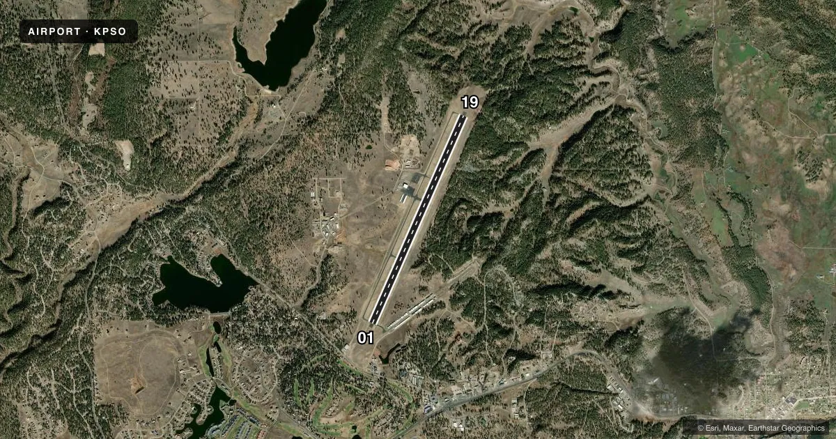
Airport sketch
Runways drawn to scale from FAA survey coordinates, rendered over satellite imagery. Not for navigation.
Approaches & charts
Services on the field
Fuel grades, oxygen, maintenance, ramp storage and lighting — as declared to the FAA by the airport operator.
Fuel & services
- Fuel
- 100LLA
- Oxygen (bottled)
- Not available
- Oxygen (bulk)
- High pressure
- Airframe repair
- Minor
- Power plant repair
- Minor
- Other services
- INSTR
Ramp & ground
- Transient storage
- Tie-down
- Hangar
- Landing fee
- No fee published
- Customs
- Not available
- Lighting schedule
- SEE RMK
- Beacon schedule
- SS-SR
- Beacon
- White / Green (civil land)(WG)
- Wind indicator
- Lighted
- Segmented circle
- Yes
Fuel & FBOs
Cheapest 100LL and Jet A on the field and nearby. Always confirm with the FBO before taxi.
Airport notes
Surface conditions, obstructions, local procedures, lighting outages and other notes published with each FAA cycle.
General notes
- WILDLIFE ON & INVOF ARPT.
- TWY B CLSD TO ACFT 12500 LBS & OVER.
- BALLOON OPS INVOF AIRPORT.
- FOR CD CTC DENVER ARTCC AT 303-651-4257.
Lighting notes
- ACTVT REIL RWY 01 & 19; PAPI RWY 01 & 19; MIRL RWY 01/19. - CTAF.
Other notes
- TPA 1000 FT AGL FOR PROP ACFT AND 1500 FT AGL FOR JET ACFT.
VFR map & nearby airports
VFR sectional. Tap any ICAO chip to open that airport.
Key facts · KPSO
Answer card- ICAO
- KPSO
- Name
- STEVENS FLD
- Location
- PAGOSA SPRINGS, COLORADO
- Elevation
- 7,663.3 ft MSL
- Traffic pattern altitude
- 8,663.3 ft MSL (1,000 AGL)
- Control tower
- Non-towered (use CTAF)
- Total runways
- 1
- Longest runway
- 01/19 · 8,100 ft
- Published ILS approaches
- 0
- Published frequencies
- 2
- Magnetic variation
- 10°
- Current flight rules
- VFR
- Current wind
- 300° at 2 kt
- Favored runway now
- RWY 01
Stevens Field sits in Pagosa Springs, Colorado. The field elevation is 7,663.3 ft MSL. It has one runway. Runway 01/19 is 8,100 ft of asphalt, which gives you solid length for the altitude. Performance planning still matters here.
This is an uncontrolled airport. CTAF and UNICOM are both 122.7. No ILS approaches are published. The Chart Supplement remarks also note that clearance delivery goes through Denver Air Route Traffic Control Center at 303-651-4257. Traffic pattern altitude is 1,000 ft AGL for propeller aircraft. That is 8,663.3 ft MSL. Jet traffic uses 1,500 ft AGL.
Blackhawk Aviation is on the field. It carries 100LL and Jet A. The airport also has a few operational items worth knowing before you arrive. Taxiway B is closed to aircraft 12,500 lb and over. Balloon operations are in the vicinity. Wildlife is also on and near the airport. Runway end identifier lights, PAPI and medium intensity runway lights are published for runways 01 and 19. At this elevation, expect high-density-altitude performance to be a real factor, especially in warm weather.