METAR & TAF C24
Current METAR
Observed 10:35Z
KC24 271035Z AUTO 29004KT 10SM FEW013 SCT210 11/10 A3049 RMK AO2 T01080102 $
- Wind
- 290° @ 4 kt
- Visibility
- 10 SM
- Temp / Dew
- 11°C / 10°C
- Altimeter
- 30.49 inHg
- Clouds
- SCT
- Density alt
- 9,576 ft
- Ceiling
- Unlimited
- Rules
- VFR
Airport info & contacts
Manager on record, flight service, ARTCC, attendance schedule and pattern altitude — published by the FAA and refreshed every 28 days.
Location
- From city
- 2 NM SSW
- VFR sectional
- DENVER
- ARTCC
- ZDV · DENVER
- NOTAM facility
- DEN (NOTAM-D)
Airport manager
- Name
- ROGER DUNCAN
- Phone
- 719-658-2360
- Address
- BOX 70, CREEDE CO 81130
Flight service · Hours
- FSS DEN
- DENVER1-800-WX-BRIEF
- Attendance
- Unattended
Frequencies
Tap any row to copy the frequency to your clipboard.
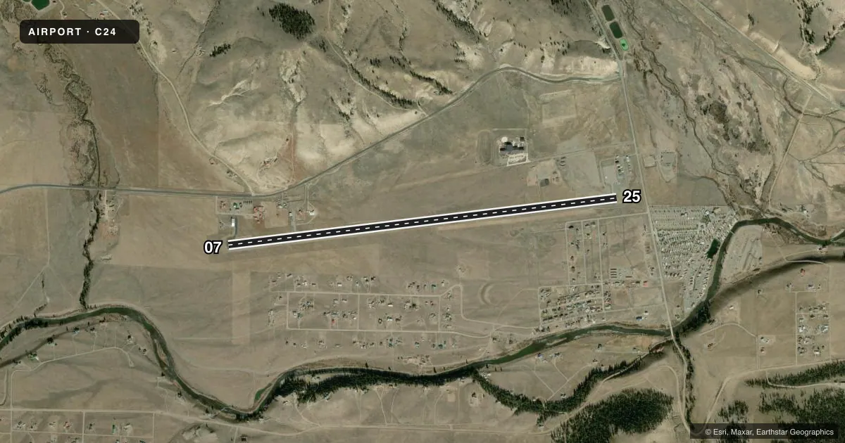
Runways & pattern
Full pagePattern entry · RWY 25
LEFT TRAFFICAirport sketch
Runways drawn to scale from FAA survey coordinates, rendered over satellite imagery. Not for navigation.
Approaches & charts
Services on the field
Fuel grades, oxygen, maintenance, ramp storage and lighting — as declared to the FAA by the airport operator.
Fuel & services
- Fuel
- 100LLA
- Oxygen (bottled)
- Not available
- Oxygen (bulk)
- Not available
- Airframe repair
- Not available
- Power plant repair
- Not available
Ramp & ground
- Transient storage
- Tie-down
- Landing fee
- No fee published
- Customs
- Not available
- Wind indicator
- Yes
- Segmented circle
- No
Fuel & FBOs
Cheapest 100LL and Jet A on the field and nearby. Always confirm with the FBO before taxi.
Airport notes
Surface conditions, obstructions, local procedures, lighting outages and other notes published with each FAA cycle.
General notes
- MT ALL QUADS.
- DEP NE AVOID OVERFLIGHT OF TRAILERS & HOMES; CLIMB TO +200 FT AGL ON RCL BFR TURN.
- GLIDER ACT & WILDLIFE ON & INVOF ARPT.
- FOR CD CTC DENVER ARTCC AT 303-651-4257.
Approach & departure obstructions
- 25LARGE ROCKS 20 - 200 FT FM RWY END.
Other notes
- MANAGER719-658-2600 CO SHERIFF 24 HRS.
VFR map & nearby airports
VFR sectional. Tap any ICAO chip to open that airport.
Key facts · C24
Answer card- ICAO
- C24
- Name
- MINERAL COUNTY MEML
- Location
- CREEDE, COLORADO
- Elevation
- 8,680 ft MSL
- Traffic pattern altitude
- 9,680 ft MSL (1,000 AGL)
- Control tower
- Non-towered (use CTAF)
- Total runways
- 1
- Longest runway
- 07/25 · 6,880 ft
- Published ILS approaches
- 0
- Published frequencies
- 1
- Magnetic variation
- 12°
- Current flight rules
- VFR
- Current wind
- 290° at 4 kt
- Favored runway now
- RWY 25
Mineral County Memorial Airport sits in Creede, Colorado. The field elevation is 8,680 ft MSL. It has one runway, 07/25, which is 6,880 ft long. The airport is non-towered. CTAF is 122.9. No ILS approaches are published.
Pattern altitude is not published. Use the standard 1,000 ft AGL pattern for light piston traffic unless the current Chart Supplement says otherwise. The airport sits in mountain country. Mountains are in all quadrants. Density altitude can be a real factor here because of the elevation. Plan performance with that in mind.
There are no on-field FBOs listed. Check with the airport operator or call the field directly before arrival if you need local services. Published remarks call out a departure to the northeast to avoid trailers and homes. They also say to climb to more than 200 ft AGL on the right centerline before turning. Large rocks are close to the runway end. Glider activity and wildlife are present on and near the airport. The manager can be reached at 719-658-2600. For clearance delivery, contact Denver ARTCC at 303-651-4257.