METAR & TAF 04V
Current METAR
Observed 11:55Z
K04V 271155Z AUTO 31011KT 10SM CLR 13/12 A3042 RMK AO2 PWINO
- Wind
- 310° @ 11 kt
- Visibility
- 10 SM
- Temp / Dew
- 13°C / 12°C
- Altimeter
- 30.42 inHg
- Clouds
- CLR
- Density alt
- 8,874 ft
- Ceiling
- Unlimited
- Rules
- VFR
Airport info & contacts
Manager on record, flight service, ARTCC, attendance schedule and pattern altitude — published by the FAA and refreshed every 28 days.
Location
- From city
- 2 NM NW
- VFR sectional
- DENVER
- ARTCC
- ZDV · DENVER
- NOTAM facility
- 04V (NOTAM-D)
Airport manager
- Name
- WENDY MAEZ
- Phone
- 719-655-2231
- Address
- P.O. BOX 476, SAGUACHE CO 81149
Flight service · Hours
- FSS DEN
- DENVER1-800-WX-BRIEF
- Attendance
- Unattended
Frequencies
Tap any row to copy the frequency to your clipboard.
Runways & pattern
Full pagePattern entry · RWY 29
LEFT TRAFFICRunway end performance
| End | TORA | TODA | ASDA | LDA | VGSI | Approach lights | Obstruction |
|---|---|---|---|---|---|---|---|
| 11 | — | — | — | — | — | — | 15', road, 64' from thr, 0' R of cntrln, slope 4 |
Declared distances in feet. TORA = takeoff run available, TODA = takeoff distance, ASDA = accelerate-stop, LDA = landing distance.
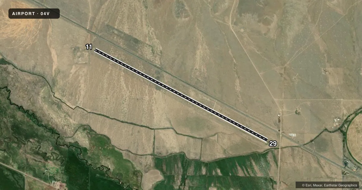
Airport sketch
Runways drawn to scale from FAA survey coordinates, rendered over satellite imagery. Not for navigation.
Approaches & charts
Services on the field
Fuel grades, oxygen, maintenance, ramp storage and lighting — as declared to the FAA by the airport operator.
Fuel & services
- Fuel
- Not available
Ramp & ground
- Transient storage
- Not published
- Landing fee
- No fee published
- Wind indicator
- Yes
- Segmented circle
- Yes
Fuel & FBOs
Cheapest 100LL and Jet A on the field and nearby. Always confirm with the FBO before taxi.
Airport notes
Surface conditions, obstructions, local procedures, lighting outages and other notes published with each FAA cycle.
General notes
- FOR CURRENT ARPT CONDS CTC AMGR 719-655-2231.
- WILDLIFE ON & INVOF ARPT & UNLTD VEHICLE USE ON ARPT.
- FOR CD CTC DENVER ARTCC AT 303-651-4257.
Runway surface & condition
- 11/29PRAIRIE DOG HOLES RWY EDGE NEAR RWY 29 END; +2 FT BUSHES VRBL ALG EDGE.
Approach & departure obstructions
- 29-4 FT TRRN 70 FT L OF CNTRLN AT THLD; -5 FT DITCH 288 FT FM THR BOTH SIDES.
- 11RWY NRS 55X75 FT ASPH PADS.
- 29RWY NRS 55X75 FT ASPH PADS.
Other notes
- PROVDD A 20:1 OBSTRUCTION-FREE APCH SFC ARE MAINTAINED AT BOTH RWY ENDS.
- 11/29SOFT WHEN WET.
VFR map & nearby airports
VFR sectional. Tap any ICAO chip to open that airport.
Key facts · 04V
Answer card- ICAO
- 04V
- Name
- SAGUACHE MUNI
- Location
- SAGUACHE, COLORADO
- Elevation
- 7,850 ft MSL
- Traffic pattern altitude
- 8,850 ft MSL (1,000 AGL)
- Control tower
- Non-towered (use CTAF)
- Total runways
- 1
- Longest runway
- 11/29 · 7,957 ft
- Published ILS approaches
- 0
- Published frequencies
- 1
- Magnetic variation
- 12°
- Current flight rules
- VFR
- Current wind
- 310° at 11 kt
- Favored runway now
- RWY 29
Saguache Muni (04V) sits in Saguache, Colorado at 7,850 ft MSL. It has one runway, 11/29, which is 7,957 ft long. The field is not towered. CTAF is 122.9. No ILS approaches are published here.
Pattern altitude is not published. Use 8,850 ft MSL as the standard 1,000 ft AGL pattern reference for light piston traffic unless the current Chart Supplement or local guidance says otherwise. The runway is gravel-dirt. The published remarks also note asphalt pads at the runway numbers. The surface is soft when wet. Wildlife is on and near the airport. Prairie dog holes are reported near the runway 29 end. There are also terrain and ditch notes near the threshold. That makes a careful low approach and landing rollout important here.
There are no on-field FBOs listed in the facts. Contact the airport manager at 719-655-2231 for current airport conditions. For clearance delivery, contact Denver ARTCC at 303-651-4257. This is a high-elevation airport in mountain country. Performance planning matters. Check density altitude, runway condition and winds before you go. If you need current noise or operating restrictions, verify them in the current FAA Chart Supplement or with the airport operator before departure.