METAR & TAF KAEJ
Current METAR
Observed 12:55Z
KAEJ 271255Z AUTO 29003KT 10SM CLR 14/12 A3042 RMK AO2 T01350117
- Wind
- 290° @ 3 kt
- Visibility
- 10 SM
- Temp / Dew
- 14°C / 12°C
- Altimeter
- 30.42 inHg
- Clouds
- CLR
- Density alt
- 9,118 ft
- Ceiling
- Unlimited
- Rules
- VFR
Airport info & contacts
Manager on record, flight service, ARTCC, attendance schedule and pattern altitude — published by the FAA and refreshed every 28 days.
Location
- From city
- 2 NM S
- VFR sectional
- DENVER
- ARTCC
- ZDV · DENVER
- NOTAM facility
- DEN (NOTAM-D)
Airport manager
- Name
- CHANDRA SWANSON
- Phone
- 719-395-3496
- Address
- 27960 COUNTY ROAD 319, BUENA VISTA CO 81211
Flight service · Hours
- FSS DEN
- DENVER1-800-WX-BRIEF
- Attendance
- 0800-1500
Frequencies
Tap any row to copy the frequency to your clipboard.
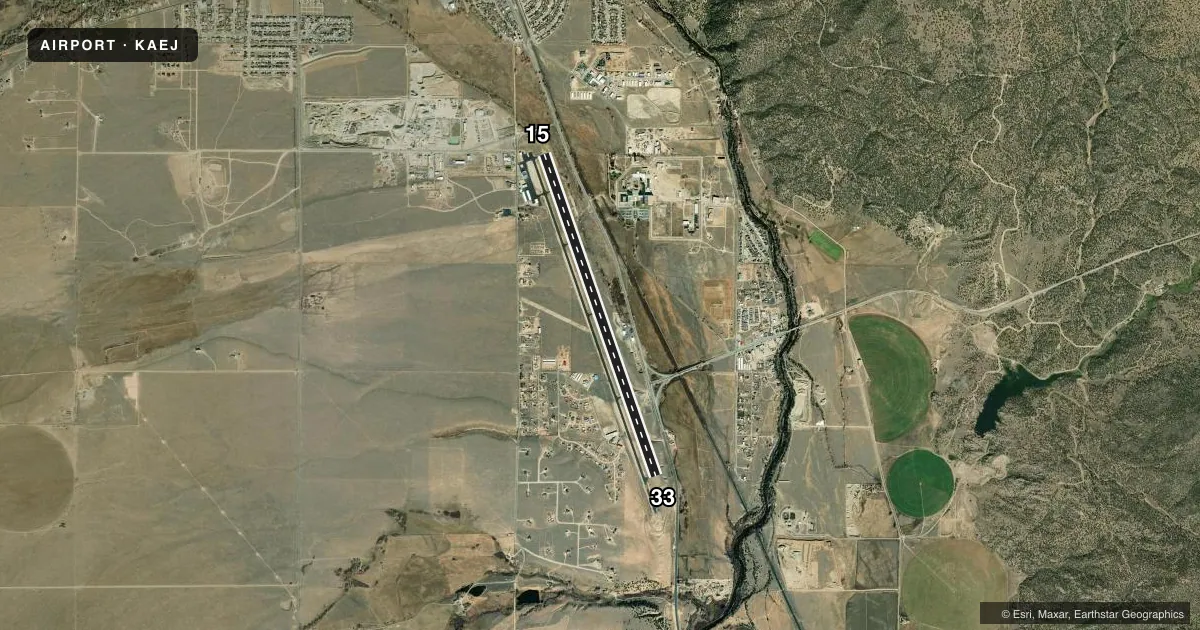
Runways & pattern
Full pagePattern entry · RWY 33
LEFT TRAFFICRunway end performance
| End | TORA | TODA | ASDA | LDA | VGSI | Approach lights | Obstruction |
|---|---|---|---|---|---|---|---|
| 15 | — | — | — | — | PAPI 2-box left(3°) | — | 24', tree, 750' from thr, 162' R of cntrln, slope 22 |
| 33 | — | — | — | — | PAPI 2-box left(3°) | — | — |
Declared distances in feet. TORA = takeoff run available, TODA = takeoff distance, ASDA = accelerate-stop, LDA = landing distance.
Airport sketch
Runways drawn to scale from FAA survey coordinates, rendered over satellite imagery. Not for navigation.
Approaches & charts
Services on the field
Fuel grades, oxygen, maintenance, ramp storage and lighting — as declared to the FAA by the airport operator.
Fuel & services
- Fuel
- 100LLA
- Oxygen (bottled)
- Not available
- Oxygen (bulk)
- Not available
- Airframe repair
- Minor
- Power plant repair
- Minor
- Other services
- INSTR
Ramp & ground
- Transient storage
- Tie-down
- Hangar
- Landing fee
- No fee published
- Customs
- Not available
- Lighting schedule
- SEE RMK
- Beacon schedule
- SS-SR
- Beacon
- White / Green (civil land)(WG)
- Wind indicator
- Lighted
- Segmented circle
- Yes
Fuel & FBOs
Cheapest 100LL and Jet A on the field and nearby. Always confirm with the FBO before taxi.
Airport notes
Surface conditions, obstructions, local procedures, lighting outages and other notes published with each FAA cycle.
General notes
- COLD TEMPERATURE AIRPORT. ALTITUDE CORRECTION REQUIRED AT OR BELOW -21C.
- ALL TWYS MKD WITH BLUE/YELLOW REFLECTORS.
- DEER ON & INVOF ARPT.
- -3 FT DRAINAGE DITCH 170 FT E OF RY 15/33 CNTRLN, FULL LENGTH.
- RY 15 HAS +25 FT TREE 765 FT FM THLD 275 R OF CNTRLN.
- FOR CD CTC DENVER ARTCC AT 303-651-4257.
Lighting notes
- ACTVT MIRL RY 15/33 & PAPI RYS 15 & 33 - CTAF.
Approach & departure obstructions
- 33PAPI UNUSE BYD 9 DEG LEFT OF COURSE.
Other notes
- 1FOR SVC AFTER HRS CALL 719-395-3496.
- MANAGERFLIGHT LINE PHONE 719-966-9098
VFR map & nearby airports
VFR sectional. Tap any ICAO chip to open that airport.
Key facts · KAEJ
Answer card- ICAO
- KAEJ
- Name
- CENTRAL COLORADO RGNL
- Location
- BUENA VISTA, COLORADO
- Elevation
- 7,950.4 ft MSL
- Traffic pattern altitude
- 8,950.4 ft MSL (1,000 AGL)
- Control tower
- Non-towered (use CTAF)
- Total runways
- 1
- Longest runway
- 15/33 · 8,303 ft
- Published ILS approaches
- 0
- Published frequencies
- 2
- Magnetic variation
- 11°
- Current flight rules
- VFR
- Current wind
- 290° at 3 kt
- Favored runway now
- RWY 33
Central Colorado Rgnl Airport is in Buena Vista, Colorado. Field elevation is 7,950.4 ft MSL. The airport has one runway. Runway 15/33 is 8,303 ft long with asphalt pavement. There is no control tower, so use CTAF 122.8 for self-announce traffic. Pattern altitude is not published. Use the standard 1,000 ft AGL pattern unless the current Chart Supplement says otherwise.
There are no published ILS approaches here. The on-field FBO is Central Colorado Regional Airport. It carries AVGAS 100LL, Jet A and Jet A Prist. For after-hours service, call the field at 719-395-3496. The airport sits at high elevation, so performance planning matters. This is also a cold temperature airport. Altitude correction is required at or below minus 21 degrees Celsius.
A few published remarks matter on arrival. Deer are on and near the airport. Runway 15 has a tree 25 ft high about 765 ft from the threshold, 275 degrees right of centerline. The PAPI on runway 33 is unusable beyond 9 degrees left of course. Taxiways use blue and yellow reflectors. Check the current FAA Chart Supplement for any updated operational notes before you go.