METAR & TAF 1V6
Current METAR
Observed 10:35Z
K1V6 271035Z AUTO 30014KT 10SM FEW039 SCT090 SCT110 22/14 A3012 RMK AO1
- Wind
- 300° @ 14 kt
- Visibility
- 10 SM
- Temp / Dew
- 22°C / 14°C
- Altimeter
- 30.12 inHg
- Clouds
- SCT
- Density alt
- 7,341 ft
- Ceiling
- Unlimited
- Rules
- VFR
Airport info & contacts
Manager on record, flight service, ARTCC, attendance schedule and pattern altitude — published by the FAA and refreshed every 28 days.
Location
- From city
- 6 NM E
- VFR sectional
- DENVER
- Pattern altitude
- 1,058 ft AGL · 6,500 ft MSL
- ARTCC
- ZDV · DENVER
- NOTAM facility
- DEN (NOTAM-D)
Airport manager
- Name
- WESLEY BRANDT
- Phone
- 719-784-3816
- Address
- 60298 HIGHWAY 50, PENROSE CO 81240
Flight service · Hours
- FSS DEN
- DENVER1-800-WX-BRIEF
- Attendance
- 0800-1700
Frequencies
Tap any row to copy the frequency to your clipboard.
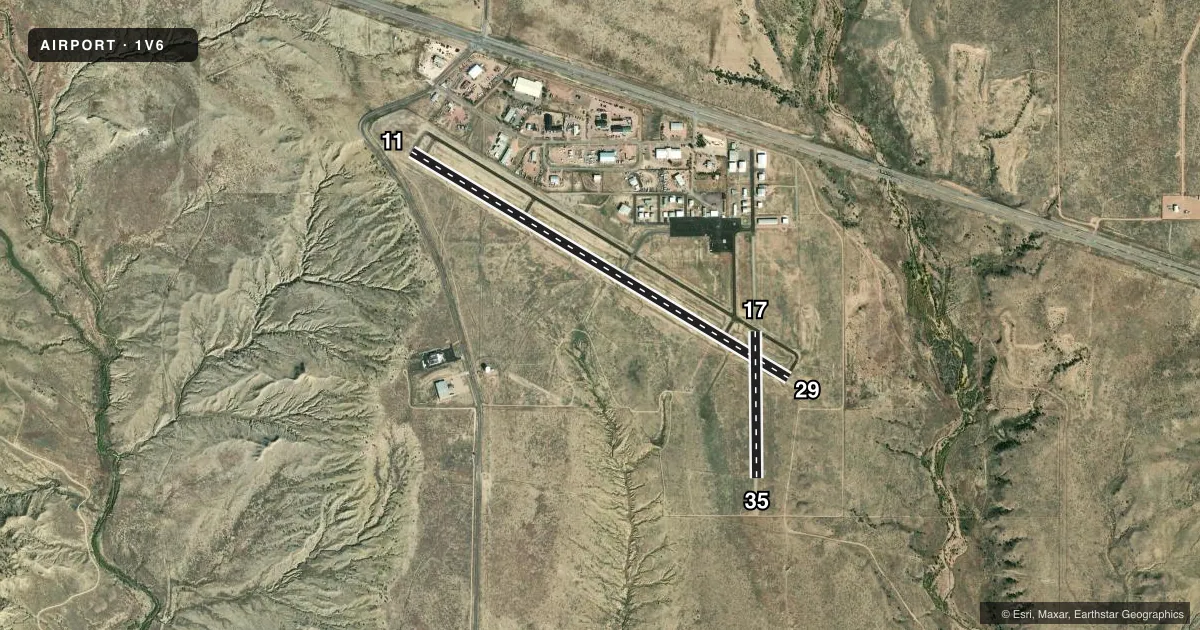
Runways & pattern
Full pagePattern entry · RWY 29
LEFT TRAFFIC| Runway | Heading (°M) | Length | Surface | Traffic |
|---|---|---|---|---|
| 11/29Favored | 113° / 293° | 5,399 ft | ASPH | Standard L |
| 17/35 | 171° / 351° | 1,800 ft | TURF-GRVL | Standard L |
Runway end performance
| End | TORA | TODA | ASDA | LDA | VGSI | Approach lights | Obstruction |
|---|---|---|---|---|---|---|---|
| 11 | — | — | — | — | PAPI 2-box left(3°) | — | — |
| 29 | — | — | — | — | PAPI 2-box left(3°) | — | — |
| 17 | — | — | — | — | — | — | 30', bldg, 1270' from thr, 35' R of cntrln, slope 42 |
Declared distances in feet. TORA = takeoff run available, TODA = takeoff distance, ASDA = accelerate-stop, LDA = landing distance.
Airport sketch
Runways drawn to scale from FAA survey coordinates, rendered over satellite imagery. Not for navigation.
Approaches & charts
Services on the field
Fuel grades, oxygen, maintenance, ramp storage and lighting — as declared to the FAA by the airport operator.
Fuel & services
- Fuel
- 100LLA
- Oxygen (bulk)
- HIGH/LOW
- Airframe repair
- Major
- Power plant repair
- Major
- Other services
- CHTR,INSTR,PAJA,RNTL
Ramp & ground
- Transient storage
- Tie-down
- Hangar
- Landing fee
- No fee published
- Customs
- Not available
- Lighting schedule
- SEE RMK
- Beacon schedule
- SS-SR
- Beacon
- White / Green (civil land)(WG)
- Wind indicator
- Lighted
- Segmented circle
- No
Fuel & FBOs
Cheapest 100LL and Jet A on the field and nearby. Always confirm with the FBO before taxi.
Airport notes
Surface conditions, obstructions, local procedures, lighting outages and other notes published with each FAA cycle.
General notes
- APRON AREAS LGTD.
- PAVED TWYS MKD WITH BLUE & WHITE REFLECTORS.
- GLDR OPS & TOWING ON & INVOF ARPT.
- 2 FT TRRN W OF RWY 17/35 & FIRST 250 FT S OF RWY 11/29.
- CTN: USAF STUDENT TRNG INVOF COLORADO SPRINGS & PUEBLO COLORADO.
- FOR CD CTC DENVER APCH AT 303-342-1916, WHEN APCH CLSD CTC DENVER ARTCC AT 303-651-4257.
Lighting notes
- ACTVT REIL RWY 11 & 29; PAPI RWY 11 & 29; MIRL RWY 11/29 - CTAF.
Runway surface & condition
- 17/35VRBL 35 - 45 FT.
Approach & departure obstructions
- 17+32 FT HNGR 1495 FT FM THR 100 FT R OF EXTNDD CNTRLN.
Other notes
- MANAGERAFT HR - 719-429-3816.
- 17/35PRARIE DOG HOLES THRUT.
- 17/35CROSSES ASPH TWY & RWY.
VFR map & nearby airports
VFR sectional. Tap any ICAO chip to open that airport.
Key facts · 1V6
Answer card- ICAO
- 1V6
- Name
- FREMONT COUNTY
- Location
- CANON CITY, COLORADO
- Elevation
- 5,442.4 ft MSL
- Traffic pattern altitude
- 6,500.4 ft MSL (1,058 AGL)
- Control tower
- Non-towered (use CTAF)
- Total runways
- 2
- Longest runway
- 11/29 · 5,399 ft
- Published ILS approaches
- 0
- Published frequencies
- 4
- Magnetic variation
- 8°
- Current flight rules
- VFR
- Current wind
- 300° at 14 kt
- Favored runway now
- RWY 29
Fremont County Airport sits in Canon City, Colorado. Field elevation is 5,442.4 ft MSL. The airport has two runways. The longest is 11/29 at 5,399 ft. Runway 17/35 is 1,800 ft turf and gravel. There is no control tower. The pattern altitude is 6,500.4 ft MSL, which is 1,058 ft AGL.
No ILS approaches are published here. For current approach and clearance details, use the current FAA Chart Supplement or call the airport operator. The on-field FBO is Fremont County Airport. It carries 100LL and Jet A Prist. Call (719) 784-3816 for current service details. After hours, contact 719-429-3816.
A first-time pilot should pay attention to the field elevation and the nearby terrain. There is 2-foot terrain west of runway 17/35. There is also 2-foot terrain in the first 250 feet south of runway 11/29. Runway 17/35 also has prairie dog holes throughout the surface. Glider operations and towing are active on and near the airport. Runway 11/29 has edge lighting, PAPI and runway end identifier lights. The lights are CTAF controlled. Denver Approach handles clearance delivery at 303-342-1916. Watch for military training traffic in the wider area around Colorado Springs and Pueblo.