METAR & TAF 4V1
Current METAR
Observed 12:35Z
K4V1 271235Z AUTO 24008KT 10SM CLR 23/11 A3018 RMK AO2
- Wind
- 240° @ 8 kt
- Visibility
- 10 SM
- Temp / Dew
- 23°C / 11°C
- Altimeter
- 30.18 inHg
- Clouds
- CLR
- Density alt
- 8,145 ft
- Ceiling
- Unlimited
- Rules
- VFR
Airport info & contacts
Manager on record, flight service, ARTCC, attendance schedule and pattern altitude — published by the FAA and refreshed every 28 days.
Location
- From city
- 5 NM N
- VFR sectional
- DENVER
- ARTCC
- ZDV · DENVER
- NOTAM facility
- DEN (NOTAM-D)
Airport manager
- Name
- DUSTIN HRIBAR
- Phone
- 719-989-0376
- Address
- 401 MAIN ST, WALSENBURG CO 81089
Flight service · Hours
- FSS DEN
- DENVER1-800-WX-BRIEF
- Attendance
- IREG
Frequencies
Tap any row to copy the frequency to your clipboard.
Runways & pattern
Full pagePattern entry · RWY 20
LEFT TRAFFIC| Runway | Heading (°M) | Length | Surface | Traffic |
|---|---|---|---|---|
| 09/27 | 85° / 265° | 4,715 ft | ASPH | Standard L |
| 02/20Favored | 23° / 203° | 2,238 ft | TURF-DIRT | Standard L |
Runway end performance
| End | TORA | TODA | ASDA | LDA | VGSI | Approach lights | Obstruction |
|---|---|---|---|---|---|---|---|
| 09 | 4,502' | 4,502' | 4,502' | 4,502' | PAPI 2-box left(3°) | — | — |
| 27 | 4,712' | 4,712' | 4,712' | 4,712' | PAPI 2-box left(3°) | — | — |
| 02 | 2,012' | 2,012' | 2,012' | 2,012' | — | — | 12', fence, 200' from thr, 0' R of cntrln, slope 16 |
| 20 | 2,012' | 2,012' | 2,012' | 2,012' | — | — | — |
Declared distances in feet. TORA = takeoff run available, TODA = takeoff distance, ASDA = accelerate-stop, LDA = landing distance.
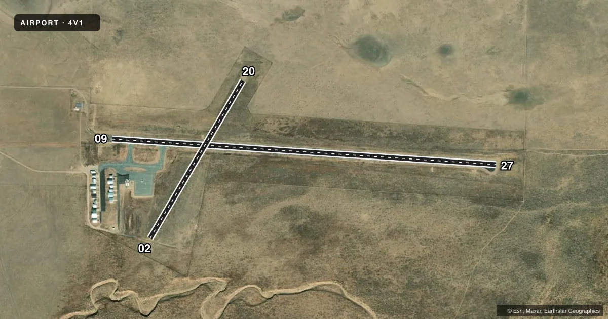
Airport sketch
Runways drawn to scale from FAA survey coordinates, rendered over satellite imagery. Not for navigation.
Approaches & charts
Services on the field
Fuel grades, oxygen, maintenance, ramp storage and lighting — as declared to the FAA by the airport operator.
Fuel & services
- Fuel
- 100LLA
- Oxygen (bottled)
- Not available
- Oxygen (bulk)
- Not available
- Other services
- INSTR,RNTL
Ramp & ground
- Transient storage
- Tie-down
- Landing fee
- No fee published
- Lighting schedule
- SEE RMK
- Wind indicator
- Lighted
- Segmented circle
- No
Fuel & FBOs
Cheapest 100LL and Jet A on the field and nearby. Always confirm with the FBO before taxi.
Airport notes
Surface conditions, obstructions, local procedures, lighting outages and other notes published with each FAA cycle.
General notes
- BE ALERT: INTENSIVE USAF STUDENT TRNG ACT INVOF COLORADO SPRINGS & PUEBLO, CO.
- FOR CD CTC DENVER ARTCC AT 303-651-4257.
Lighting notes
- ACTVT PAPI RWY 09 & 27; MIRL RWY 09/27 - CTAF.
Fuel notes
- 100LL24 HR CREDIT CARD FUEL AVBL.
Runway surface & condition
- 02/20RWY 02/20 CLSD EXCP PPR CTC AMGR PRIOR TO USE 719-742-5323 OR 719-859-5323.
Approach & departure obstructions
- 02RWY 02 5 FT FENCE AT THLD BOTH SIDES OF CNTRLN.
- 20RWY 20 4 FT FENCE 240 FT FM THLD BOTH SIDES OF CNTRLN.
- 09APCH SLOPE 50:1 FM DTHR.
Other notes
- EXISTED PRIOR TO 1959.
- 02/20RWY 02 ROUGH AND NOT WELL MAINTAINED.
- 02/20RWY 02 FIRST 1000 FT HAS RUTS AND BUMPS.
VFR map & nearby airports
VFR sectional. Tap any ICAO chip to open that airport.
Key facts · 4V1
Answer card- ICAO
- 4V1
- Name
- SPANISH PEAKS AIRFIELD
- Location
- WALSENBURG, COLORADO
- Elevation
- 6,054.7 ft MSL
- Traffic pattern altitude
- 7,054.7 ft MSL (1,000 AGL)
- Control tower
- Non-towered (use CTAF)
- Total runways
- 2
- Longest runway
- 09/27 · 4,715 ft
- Published ILS approaches
- 0
- Published frequencies
- 2
- Magnetic variation
- 8°
- Current flight rules
- VFR
- Current wind
- 240° at 8 kt
- Favored runway now
- RWY 20
Spanish Peaks Airfield sits in Walsenburg, Colorado at 6,054.7 ft MSL. It has two runways. The longest is 09/27 at 4,715 ft asphalt. Runway 02/20 is 2,238 ft turf-dirt. This is an untowered field. CTAF and UNICOM are both 122.8. No ILS approaches are published.
Pattern altitude is not published. Use the standard 1,000 ft AGL for light piston traffic unless the current Chart Supplement or the airport operator says otherwise. The field carries a magnetic variation of 8°. Runway 09 has PAPI lighting. Runways 09 and 27 also have medium intensity runway lighting that is controlled by CTAF. That helps for night work, but you still need to verify current lighting status before departure.
Spanish Peaks Airfield has one on-field FBO. Spanish Peaks Airfield carries 100LL and Jet A. Twenty-four hour credit card fuel is available. Runway 02/20 has several cautions in the published remarks. Runway 02 is closed except by prior permission. The first 1,000 feet of runway 02 has ruts and bumps. There is also a fence near the threshold on runway 02 and another fence near runway 20. Expect high-elevation performance planning here. The airport also notes intensive military student training activity in the Colorado Springs and Pueblo area. Check the current Chart Supplement and call the airport operator before using runway 02/20.