METAR & TAF KTAD
Current METAR
Observed 09:54Z
KTAD 270954Z AUTO 25010KT 10SM CLR 22/11 A3014 RMK AO2 SLP096 T02220106
- Wind
- 250° @ 10 kt
- Visibility
- 10 SM
- Temp / Dew
- 22°C / 11°C
- Altimeter
- 30.14 inHg
- Clouds
- CLR
- Density alt
- 7,712 ft
- Ceiling
- Unlimited
- Rules
- VFR
Airport info & contacts
Manager on record, flight service, ARTCC, attendance schedule and pattern altitude — published by the FAA and refreshed every 28 days.
Location
- From city
- 10 NM NE
- VFR sectional
- DENVER
- ARTCC
- ZDV · DENVER
- NOTAM facility
- TAD (NOTAM-D)
Airport manager
- Name
- EVAN OTTO
- Phone
- 719-680-7831
- Address
- 44814 CO RD 38.0, TRINIDAD CO 81082-9607
Flight service · Hours
- FSS DEN
- DENVER1-800-WX-BRIEF
- Attendance
- MON-FRI · 0800-1700
Frequencies
Tap any row to copy the frequency to your clipboard.
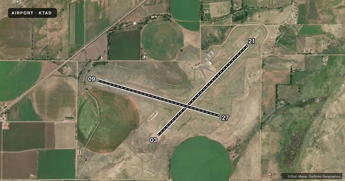
Runways & pattern
Full pagePattern entry · RWY 21
RIGHT TRAFFIC| Runway | Heading (°M) | Length | Surface | Traffic |
|---|---|---|---|---|
| 09/27 | 96° / 276° | 5,500 ft | TURF-GRVL | Standard L |
| 03/21Favored | 35° / 215° | 5,500 ft | ASPH | 21 R |
Runway end performance
| End | TORA | TODA | ASDA | LDA | VGSI | Approach lights | Obstruction |
|---|---|---|---|---|---|---|---|
| 09 | — | — | — | — | — | — | 41', trees, 784' from thr, 151' R of cntrln, slope 19 |
| 03 | — | — | — | — | PAPI 2-box left(3°) | — | — |
| 21 | — | — | — | — | PAPI 2-box left(3°) | — | — |
Declared distances in feet. TORA = takeoff run available, TODA = takeoff distance, ASDA = accelerate-stop, LDA = landing distance.
Airport sketch
Runways drawn to scale from FAA survey coordinates, rendered over satellite imagery. Not for navigation.
Approaches & charts
Services on the field
Fuel grades, oxygen, maintenance, ramp storage and lighting — as declared to the FAA by the airport operator.
Fuel & services
- Fuel
- 100LLA+
Ramp & ground
- Transient storage
- Tie-down
- Hangar
- Landing fee
- Yes
- Customs
- Not available
- Lighting schedule
- SEE RMK
- Beacon schedule
- SS-SR
- Beacon
- White / Green (civil land)(WG)
- Wind indicator
- Lighted
- Segmented circle
- No
Fuel & FBOs
Cheapest 100LL and Jet A on the field and nearby. Always confirm with the FBO before taxi.
Airport notes
Surface conditions, obstructions, local procedures, lighting outages and other notes published with each FAA cycle.
General notes
- TWYS HAVE BLUE/WHITE REFLECTORS AT PAVEMENT EDGE.
- ALERT: USAF STUDENT TRNG INVOF COLORADO SPRINGS & PUEBLO CO.
- FOR CD IF UNA TO CTC ON FSS FREQ, CTC DENVER ARTCC AT 303-651-4257.
Lighting notes
- ACTVT REIL RWY 03 & 21; PAPI RWY 03 & 21; MIRL RWY 03/21 - CTAF. PPR.
Runway surface & condition
- 09/27+3-6 FT BUSHES ON EDGE BOTH SIDES ALG ENTRE LEN; SOFT WHEN WET; PRAIRIE DOG HOLES THRUT.
Approach & departure obstructions
- 09+40 FT TREES 846 FT FM THR 137 FT RIGHT; +4 FT BUSHES & +3 FT POSTS WI 100 FT OF RWY END BOTH SIDES OF CNTRLN.
VFR map & nearby airports
VFR sectional. Tap any ICAO chip to open that airport.
Key facts · KTAD
Answer card- ICAO
- KTAD
- Name
- PERRY STOKES
- Location
- TRINIDAD, COLORADO
- Elevation
- 5,761.6 ft MSL
- Traffic pattern altitude
- 6,761.6 ft MSL (1,000 AGL)
- Control tower
- Non-towered (use CTAF)
- Total runways
- 2
- Longest runway
- 09/27 · 5,500 ft
- Published ILS approaches
- 0
- Published frequencies
- 2
- Magnetic variation
- 10°
- Current flight rules
- VFR
- Current wind
- 250° at 10 kt
- Favored runway now
- RWY 21
Perry Stokes is in Trinidad, Colorado. The field elevation is 5,761.6 ft MSL. It has two runways. The longest is 5,500 ft. There is no control tower. CTAF and UNICOM are both 122.8. No ILS approaches are published.
The pattern altitude is not published. Use the standard 1,000 ft AGL pattern for light piston aircraft unless the current Chart Supplement says otherwise. Pinnacle Jet Center is on the field. It carries 100LL and Jet A. Call (719) 680-7831 before arrival if you need current service details.
Runway 03/21 has runway end identifier lights, PAPI and medium intensity runway lighting. The lighting is controlled on CTAF. Prior permission is required. Published remarks also call out trees near the 09 threshold and small bushes and posts near the runway end. Runway 09/27 has bushes along the edge, soft spots when wet and prairie dog holes through the runway. That makes a careful preflight and a current surface check important. There is also military student training traffic in the Colorado Springs and Pueblo area. Expect a busy scan if you are operating in that region.