METAR & TAF 07V
07V does not publish a METAR.
Showing the nearest reporting station: KTAD (PERRY STOKES) · 35.6 NM away. Conditions at 07V may differ.
METAR · KTAD
Observed 18:54Z
KTAD 251854Z AUTO 00000KT 10SM FEW100 35/07 A3023 RMK AO2 SLP130 T03500072
- Wind
- 000° @ 0 kt
- Visibility
- 10 SM
- Temp / Dew
- 35°C / 7°C
- Altimeter
- 30.23 inHg
- Clouds
- FEW
- Density alt
- 10,885 ft
- Ceiling
- Unlimited
- Rules
- VFR
Airport info & contacts
Manager on record, flight service, ARTCC, attendance schedule and pattern altitude — published by the FAA and refreshed every 28 days.
Location
- From city
- 1 NM N
- VFR sectional
- DENVER
- ARTCC
- ZDV · DENVER
- NOTAM facility
- DEN (NOTAM-D)
Airport manager
- Name
- OPEN
- Phone
- (719) 742-3631
- Address
- TOWN HALL BOX 174, LA VETA CO 81055
Flight service · Hours
- FSS DEN
- DENVER1-800-WX-BRIEF
- Attendance
- UNATTENDED
Frequencies
Tap any row to copy the frequency to your clipboard.
Runways & pattern
Full pagePattern entry · RWY 06
LEFT TRAFFICRunway end performance
| End | TORA | TODA | ASDA | LDA | VGSI | Approach lights | Obstruction |
|---|---|---|---|---|---|---|---|
| 24 | — | — | — | — | — | — | 15', road, 399' from thr, 25' R of cntrln, slope 13 |
Declared distances in feet. TORA = takeoff run available, TODA = takeoff distance, ASDA = accelerate-stop, LDA = landing distance.
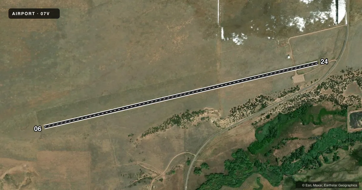
Airport sketch
Runways drawn to scale from FAA survey coordinates, rendered over satellite imagery. Not for navigation.
Approaches & charts
Services on the field
Fuel grades, oxygen, maintenance, ramp storage and lighting — as declared to the FAA by the airport operator.
Fuel & services
- Fuel
- Not available
Ramp & ground
- Transient storage
- Not published
- Landing fee
- No fee published
- Lighting schedule
- SEE RMK
- Beacon schedule
- SS-SR
- Beacon
- White / Green (civil land)(WG)
- Wind indicator
- Yes
- Segmented circle
- No
Fuel & FBOs
Cheapest 100LL and Jet A on the field and nearby. Always confirm with the FBO before taxi.
Airport notes
Surface conditions, obstructions, local procedures, lighting outages and other notes published with each FAA cycle.
General notes
- WILDLIFE ON & INVOF RWY.
- USAF STUDENT TRNG INVOF OF COLORADO SPRINGS & PUEBLO COLORADO.
- FOR CD CTC DENVER ARTCC AT 303-651-4257.
- RWY 24 HAS METAL SIGN POST WI 5 FT OF RWY EDGE AT NORTH TWY APRXLY 500 FT FM APCH END.
- RWY 24 HAS LRG HOLE MKD WITH ORANGE SAFETY CONE APRXLY 500 FT FM APCH END.
Lighting notes
- ACTVT MIRL RWY 06/24 - 122.7.
Runway surface & condition
- 06/24NON STD: RWY 6 FIRST 96 FT UNLGTD; RWY 24 FIRST 92 FT UNLGTD.
Approach & departure obstructions
- 06+7 FT FENCE 100 FT FM & PARL TO THR.
- 24+10 FT ROAD 85 FT L OF CNTRLN AT THR.
- 06MARKING FADED.
- 24MARKING FADED.
- 06+7 FT FENCE 350 FT BOTH SIDES; APCH RATIO 21:1 BASED ON DTHR.
- 24+15 FT ROAD 540 FT FM THR 105 FT L; APCH RATIO 22:1 BASED ON DTHR.
Other notes
- THIS AIRPORT HAS BEEN SURVEYED BY THE NATIONAL GEODETIC SURVEY.
- 06/24RWY & RAMP SFC CRACKING.
VFR map & nearby airports
VFR sectional. Tap any ICAO chip to open that airport.
Key facts · 07V
Answer card- ICAO
- 07V
- Name
- CUCHARA VALLEY AT LA VETA
- Location
- LA VETA, COLORADO
- Elevation
- 7,152.5 ft MSL
- Traffic pattern altitude
- 8,152.5 ft MSL (1,000 AGL)
- Control tower
- Non-towered (use CTAF)
- Total runways
- 1
- Longest runway
- 06/24 · 5,798 ft
- Published ILS approaches
- 0
- Published frequencies
- 2
- Magnetic variation
- 11°
- Current flight rules
- VFR
- Current wind
- 000° at 0 kt
- Favored runway now
- –
Cuchara Valley at La Veta is in La Veta, Colorado. The field elevation is 7,152.5 ft MSL. It has one runway. Runway 06/24 is 5,798 ft long with an asphalt surface. There is no control tower. CTAF and UNICOM are both 122.8. No ILS approaches are published here.
Pattern altitude is not published. Use the standard 1,000 ft AGL for light piston operations unless local guidance says otherwise. That puts the pattern at 8,152.5 ft MSL. The airport is high elevation, so expect performance to be different from low-country fields. Density altitude can climb fast on warm days. Plan your takeoff and landing numbers carefully.
Published remarks matter here. Runway and ramp surfaces have cracking. Runway 24 has faded markings. There is also a large hole on runway 24 marked with an orange safety cone about 500 ft from the approach end. Runway 24 has a metal sign post near the north taxiway about 500 ft from the approach end. Runway 06 has a fence near the approach path. Runway 6 and runway 24 also have non-standard lighting at the threshold end. Clearance delivery is handled through Denver ARTCC. No on-field FBOs are listed, so verify fuel and services with the airport operator or the FBO directly by phone before you go.