METAR & TAF KMVI
KMVI does not publish a METAR.
Showing the nearest reporting station: KALS (SAN LUIS VALLEY RGNL/BERGMAN FLD) · 10.2 NM away. Conditions at KMVI may differ.
METAR · KALS
Observed 11:52Z
KALS 271152Z AUTO 00000KT 10SM CLR 14/12 A3035 RMK AO2 SLP165 T01440122 10189 20122 51002 $
- Wind
- 000° @ 0 kt
- Visibility
- 10 SM
- Temp / Dew
- 14°C / 12°C
- Altimeter
- 30.35 inHg
- Clouds
- CLR
- Density alt
- 8,785 ft
- Ceiling
- Unlimited
- Rules
- VFR
Airport info & contacts
Manager on record, flight service, ARTCC, attendance schedule and pattern altitude — published by the FAA and refreshed every 28 days.
Location
- From city
- 5 NM SE
- VFR sectional
- DENVER
- ARTCC
- ZDV · DENVER
- NOTAM facility
- DEN (NOTAM-D)
Airport manager
- Name
- JED ELLITHORP
- Phone
- 719-852-3241
- Address
- 5670 E. HWY 160, MONTE VISTA CO 81144
Flight service · Hours
- FSS DEN
- DENVER1-800-WX-BRIEF
- Attendance
- MON-FRI · 0800-1700
- SAT-SUN · ON-CALL
Frequencies
Tap any row to copy the frequency to your clipboard.
Runways & pattern
Full pagePattern entry · RWY 02
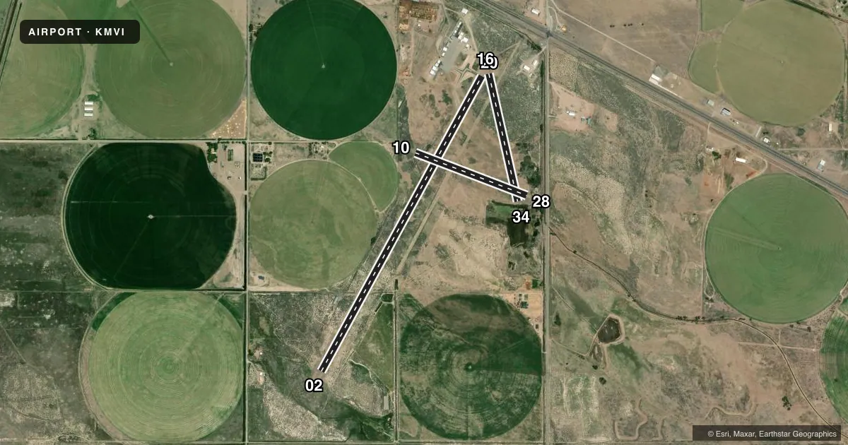
LEFT TRAFFIC| Runway | Heading (°M) | Length | Surface | Traffic |
|---|---|---|---|---|
| 02/20 | 21° / 201° | 5,902 ft | ASPH | Standard L |
| 16/34 | 159° / 339° | 2,300 ft | DIRT | Standard L |
| 10/28 | 103° / 283° | 2,100 ft | DIRT | Standard L |
Runway end performance
| End | TORA | TODA | ASDA | LDA | VGSI | Approach lights | Obstruction |
|---|---|---|---|---|---|---|---|
| 02 | — | — | — | — | PAPI 2-box left(3°) | — | — |
| 20 | — | — | — | — | PAPI 2-box left(3°) | — | 29', pline, 1085' from thr, 333' R of cntrln, slope 30 |
| 34 | — | — | — | — | — | — | 8', fence, 218' from thr, slope 27 |
| 10 | — | — | — | — | — | — | 4', fence, 69' from thr, 14' R of cntrln, slope 17 |
| 28 | — | — | — | — | — | — | 43', trees, 107' from thr, 53' R of cntrln, slope 2 |
Declared distances in feet. TORA = takeoff run available, TODA = takeoff distance, ASDA = accelerate-stop, LDA = landing distance.
Airport sketch
Runways drawn to scale from FAA survey coordinates, rendered over satellite imagery. Not for navigation.
Approaches & charts
Services on the field
Fuel grades, oxygen, maintenance, ramp storage and lighting — as declared to the FAA by the airport operator.
Fuel & services
- Fuel
- 100LL
- Oxygen (bottled)
- Not available
- Oxygen (bulk)
- Not available
- Airframe repair
- Minor
- Power plant repair
- Minor
- Other services
- AGRI
Ramp & ground
- Transient storage
- Tie-down
- Hangar
- Landing fee
- No fee published
- Customs
- Not available
- Lighting schedule
- SEE RMK
- Beacon schedule
- SS-SR
- Beacon
- White / Green (civil land)(WG)
- Wind indicator
- Lighted
- Segmented circle
- Yes
Fuel & FBOs
Cheapest 100LL and Jet A on the field and nearby. Always confirm with the FBO before taxi.
Airport notes
Surface conditions, obstructions, local procedures, lighting outages and other notes published with each FAA cycle.
General notes
- VEHICLES ON & INVOF ARPT.
- FOR CD CTC DENVER ARTCC AT 303-651-4257.
Lighting notes
- ACTVT PAPI RWY 02 & 20; MIRL RWY 02/20 - CTAF.
Runway surface & condition
- 02/20SOFT SHOULDERS.
- 10/28+2 FT DIRT WINDROW ALG N EDGE; VEGETATION THRUT RWY.
- 16/34+2 FT DIRT WINDROWS & 3+ FT VEGETATION ALG EDGES.
- 02/20430 FT DIRT SWY ON N END.
Approach & departure obstructions
- 024 FT FENCE 280 FT FM RWY END 4 FT BLW RWY END ELEV.
- 16+20 FT ANT 700 FT FM THR 215 FT R OF CNTRLN.
- 20+23 FT RAILROAD 1110 FT FM THR L & R.
- 28+30 FT PWR LINE 534 FT FM THR; +40 FT TREES 345 FT FM THR 230 R OF CNTRLN.
- 10HAYSTACK
Other notes
- NO RECORD-ARPT HAS HAD FAAP.
- 1SVC AFT HR - AMGR.
- 10/28EXTREME CROSSWIND USE ONLY.
- 10/28SOFT WHEN WET.
- 16/34SANDY & SOFT.
VFR map & nearby airports
VFR sectional. Tap any ICAO chip to open that airport.
Key facts · KMVI
Answer card- ICAO
- KMVI
- Name
- MONTE VISTA MUNI
- Location
- MONTE VISTA, COLORADO
- Elevation
- 7,611.2 ft MSL
- Traffic pattern altitude
- 8,611.2 ft MSL (1,000 AGL)
- Control tower
- Non-towered (use CTAF)
- Total runways
- 3
- Longest runway
- 02/20 · 5,902 ft
- Published ILS approaches
- 0
- Published frequencies
- 2
- Magnetic variation
- 8°
- Current flight rules
- VFR
- Current wind
- 000° at 0 kt
- Favored runway now
- –
Monte Vista Muni sits in Monte Vista, Colorado. The field elevation is 7,611.2 ft MSL. It has three runways. The longest is runway 02/20 at 5,902 ft asphalt. This is a non-towered field. CTAF and UNICOM are both 122.8. No ILS approaches are published.
The pattern altitude is not published. Use the standard 1,000 ft AGL for light piston aircraft unless the current Chart Supplement says otherwise. Alpine Aviation is on the field. It carries 100LL. Call (719) 852-3241 for current service details. Published remarks also note medium intensity lights and PAPI on runways 02 and 20. Those lights operate on CTAF. After-hours service is handled by the airport manager.
This is a high-elevation airport, so performance planning matters. Expect thinner air and longer takeoff rolls than you would see at lower fields. The published remarks also call out soft shoulders on runway 02/20. Runway 10/28 has a dirt windrow and vegetation through the runway. Runway 16/34 has dirt windrows and heavier vegetation along the edges. There are also several nearby obstructions. Check the current FAA Chart Supplement before you go. That is the best source for any field condition changes, lighting notes, or operational restrictions.