METAR & TAF KRCV
Current METAR
Observed 11:15Z
KRCV 271115Z AUTO 27007KT 10SM CLR 15/12 A3039 RMK AO2 T01500120
- Wind
- 270° @ 7 kt
- Visibility
- 10 SM
- Temp / Dew
- 15°C / 12°C
- Altimeter
- 30.39 inHg
- Clouds
- CLR
- Density alt
- 9,282 ft
- Ceiling
- Unlimited
- Rules
- VFR
Airport info & contacts
Manager on record, flight service, ARTCC, attendance schedule and pattern altitude — published by the FAA and refreshed every 28 days.
Location
- From city
- 3 NM N
- VFR sectional
- DENVER
- ARTCC
- ZDV · DENVER
- NOTAM facility
- DEN (NOTAM-D)
Airport manager
- Name
- BRIAN BURRELL
- Phone
- 719-221-6677
- Address
- 1 BRAVO TAXIWAY, DEL NORTE CO 81132
Flight service · Hours
- FSS DEN
- DENVER1-800-WX-BRIEF
- Attendance
- Unattended
Frequencies
Tap any row to copy the frequency to your clipboard.
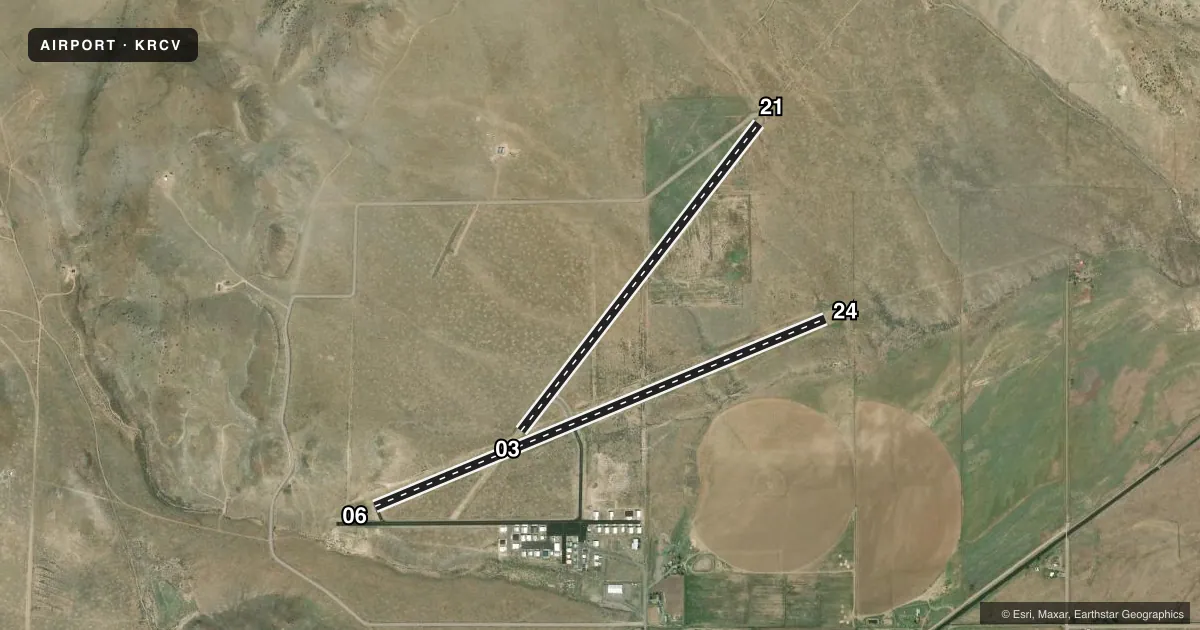
Runways & pattern
Full pagePattern entry · RWY 24
LEFT TRAFFIC| Runway | Heading (°M) | Length | Surface | Traffic |
|---|---|---|---|---|
| 06/24Favored | 59° / 239° | 6,051 ft | ASPH | 06 R |
| 03/21 | 30° / 210° | 4,812 ft | TURF | Standard L |
Runway end performance
| End | TORA | TODA | ASDA | LDA | VGSI | Approach lights | Obstruction |
|---|---|---|---|---|---|---|---|
| 06 | — | — | — | — | PAPI 2-box left(4°) | — | — |
| 24 | — | — | — | — | PAPI 2-box left(3°) | — | — |
| 21 | — | — | — | — | — | — | 19', road, 122' from thr, 57' R of cntrln, slope 6 |
Declared distances in feet. TORA = takeoff run available, TODA = takeoff distance, ASDA = accelerate-stop, LDA = landing distance.
Airport sketch
Runways drawn to scale from FAA survey coordinates, rendered over satellite imagery. Not for navigation.
Approaches & charts
Services on the field
Fuel grades, oxygen, maintenance, ramp storage and lighting — as declared to the FAA by the airport operator.
Fuel & services
- Fuel
- 100LLA+
- Other services
- AMB
Ramp & ground
- Transient storage
- Tie-down
- Landing fee
- No fee published
- Customs
- Not available
- Lighting schedule
- SEE RMK
- Beacon schedule
- SS-SR
- Beacon
- White / Green (civil land)(WG)
- Wind indicator
- Yes
- Segmented circle
- Yes
Fuel & FBOs
Cheapest 100LL and Jet A on the field and nearby. Always confirm with the FBO before taxi.
Airport notes
Surface conditions, obstructions, local procedures, lighting outages and other notes published with each FAA cycle.
General notes
- WILDLIFE ON & INVOF ARPT.
- UNL VEHICLE ACES ON ARPT.
- MTUS TRRN ALL QUADS.
- FOR CD CTC DENVER ARTCC AT 303-651-4257.
Lighting notes
- ACTVT REIL RWY 06 & 24, PAPI RWY 06 & 24, MIRL RWY 06/24 - CTAF. REIL RWY 06 & 24 ONLY OPR AT NGT.
Fuel notes
- A+FUEL AVBLTY: 100LL 24 HRS WITH CC; JET A+ BY APNTMT, CTC AMGR 719-221-6677.
Approach & departure obstructions
- 21+8 FT SIGN 20 FT FM THR 10 FT R OF CNTRLN.
- 06UNUSBL BYD 5 DEG RIGHT OF CRS.
Other notes
- ARPT EXISTED PRIOR TO 1959.
- 03/21NMRS HOLES FIRST 500 FT RWY 03; ROUGH SFC THRUT.
VFR map & nearby airports
VFR sectional. Tap any ICAO chip to open that airport.
Key facts · KRCV
Answer card- ICAO
- KRCV
- Name
- ASTRONAUT KENT ROMINGER
- Location
- DEL NORTE, COLORADO
- Elevation
- 7,955.4 ft MSL
- Traffic pattern altitude
- 8,955.4 ft MSL (1,000 AGL)
- Control tower
- Non-towered (use CTAF)
- Total runways
- 2
- Longest runway
- 06/24 · 6,051 ft
- Published ILS approaches
- 0
- Published frequencies
- 1
- Magnetic variation
- 8°
- Current flight rules
- VFR
- Current wind
- 270° at 7 kt
- Favored runway now
- RWY 24
Astronaut Kent Rominger Airport is in Del Norte, Colorado. The field elevation is 7,955.4 ft MSL. It has two runways. The longest is runway 06/24 at 6,051 ft. There is no control tower, so use CTAF 122.9 and keep your scan tight in the pattern.
No ILS approaches are published here. Pattern altitude is not published. Use the standard 1,000 ft AGL for light piston operations unless the current Chart Supplement says otherwise. Mountainous terrain is present in all quadrants, so plan your climb and descent with that in mind. Runway 06 has a published note that it is unusable beyond 5 degrees right of course. Runway 03/21 is turf. The first 500 ft of runway 03 have numerous holes. The surface is rough throughout.
The airport has 24-hour 100LL with credit card. Jet A is available by appointment. Contact the airport manager at 719-221-6677 for fuel or field questions. There are no on-field FBOs listed in the facts. REIL and PAPI are published for runways 06 and 24. The MIRL on 06/24 is controlled by CTAF. REIL on 06 and 24 operate only at night. Wildlife is also reported on and near the airport, so keep an eye out on taxi and rollout.