METAR & TAF C08
Current METAR
Observed 12:15Z
KC08 271215Z AUTO 16003KT 10SM CLR 12/10 A3041 RMK AO2
- Wind
- 160° @ 3 kt
- Visibility
- 10 SM
- Temp / Dew
- 12°C / 10°C
- Altimeter
- 30.41 inHg
- Clouds
- CLR
- Density alt
- 9,312 ft
- Ceiling
- Unlimited
- Rules
- VFR
Airport info & contacts
Manager on record, flight service, ARTCC, attendance schedule and pattern altitude — published by the FAA and refreshed every 28 days.
Location
- From city
- 9 NM SE
- VFR sectional
- DENVER
- ARTCC
- ZDV · DENVER
- NOTAM facility
- DEN (NOTAM-D)
Airport manager
- Name
- ROBERT JOLLEY
- Phone
- 719-783-2286
- Address
- P.O. BOX 150, WESTCLIFFE CO 81252
Flight service · Hours
- FSS DEN
- DENVER1-800-WX-BRIEF
- Attendance
- Unattended
Frequencies
Tap any row to copy the frequency to your clipboard.
Runways & pattern
Full pagePattern entry · RWY 13
RIGHT TRAFFICRunway end performance
| End | TORA | TODA | ASDA | LDA | VGSI | Approach lights | Obstruction |
|---|---|---|---|---|---|---|---|
| 31 | — | — | — | — | — | — | 10', gnd, 201' from thr, 8' R of cntrln, slope 0 |
Declared distances in feet. TORA = takeoff run available, TODA = takeoff distance, ASDA = accelerate-stop, LDA = landing distance.
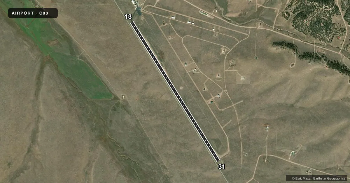
Airport sketch
Runways drawn to scale from FAA survey coordinates, rendered over satellite imagery. Not for navigation.
Approaches & charts
Services on the field
Fuel grades, oxygen, maintenance, ramp storage and lighting — as declared to the FAA by the airport operator.
Fuel & services
- Fuel
- 100LL
- Oxygen (bottled)
- Not available
- Oxygen (bulk)
- Not available
- Airframe repair
- Not available
- Power plant repair
- Not available
Ramp & ground
- Transient storage
- Tie-down
- Landing fee
- No fee published
- Wind indicator
- Yes
- Segmented circle
- Yes
Fuel & FBOs
Cheapest 100LL and Jet A on the field and nearby. Always confirm with the FBO before taxi.
Airport notes
Surface conditions, obstructions, local procedures, lighting outages and other notes published with each FAA cycle.
General notes
- DEER & ELK INVOF RWY.
- CTN: USAF STUDENT TRNG INVOF COLORADO SPRINGS & PUEBLO ARPT.
- FOR CD CTC DENVER ARTCC AT 303-651-4257.
Fuel notes
- 100LLH24 SELF SERVE.
Runway surface & condition
- 13/31+15 FT HWY 120 FT W, PARL TO RCL FULL LEN, +4 FT FENCE 100 FT W, PARL TO RCL FULL LEN.
Approach & departure obstructions
- 31+12 FT TRRN 120 FT FM THR.
- 13CTLG OBSTN EXCEEDS 45 DEG SLP.
Other notes
- 13/31-5 TO +12 FT TRRN FULL LENGTH OF RWY IN PRIM SFC.
VFR map & nearby airports
VFR sectional. Tap any ICAO chip to open that airport.
Key facts · C08
Answer card- ICAO
- C08
- Name
- SILVER WEST
- Location
- WESTCLIFFE, COLORADO
- Elevation
- 8,290 ft MSL
- Traffic pattern altitude
- 9,290 ft MSL (1,000 AGL)
- Control tower
- Non-towered (use CTAF)
- Total runways
- 1
- Longest runway
- 13/31 · 6,954 ft
- Published ILS approaches
- 0
- Published frequencies
- 1
- Magnetic variation
- 11°
- Current flight rules
- VFR
- Current wind
- 160° at 3 kt
- Favored runway now
- RWY 13
Silver West Airport sits near Westcliffe, Colorado. The field elevation is 8,290 ft MSL. It has one runway, 13/31, which is 6,954 ft long and asphalt. There is no control tower. CTAF is 122.9. No ILS approaches are published.
The pattern altitude is not published. Use the standard 1,000 ft AGL for light piston operations unless the current Chart Supplement says otherwise. On the field, Silver West Airport carries AVGAS 100LL and Jet A. 100LL is available 24 hours by self-service. The airport is high enough that density altitude will matter on warm days. Plan performance carefully. Terrain and obstructions are part of the picture here. The runway has a highway and fence west of the centerline for much of its length. There is also terrain near the threshold of runway 31, plus a published obstruction near runway 13.
Expect wildlife too. Deer and elk are reported in the area. For clearance delivery, contact Denver ARTCC. If you are new to the field, brief the runway environment before arrival and give yourself margin on climb and landing performance.